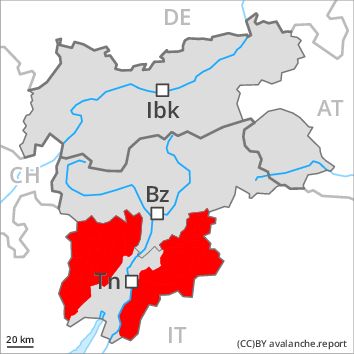
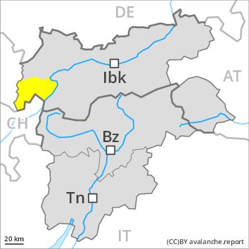
Regions
Prealps, Cembra Valley, Bondone and Stivo, Ledro Valley, Paganella
Danger level
Danger Level 4 - High above the treeline
Danger Level 3 - Considerable above the treeline
Avalanche Problem
Wet snow above the treeline, N-NE-E-SE-S-SW-W-NW
Gliding snow above 2200m

As a consequence of fresh snow and stormy weather a critical avalanche situation will be encountered in some regions. As the snowfall level rises individual medium-sized and, in isolated cases, large moist loose snow avalanches are possible below approximately 2200 m.
Natural avalanches must be expected. On steep grassy slopes numerous medium-sized and, in many cases, large gliding avalanches are to be expected below approximately 2200 m. The prevalence of avalanche prone locations and likelihood of triggering will increase with altitude. As the precipitation becomes more intense the prevalence and size of the avalanche prone locations will increase as the day progresses, in particular in the east. The danger of wet and gliding avalanches will increase during the day. During the morning as well, individual, then as the precipitation becomes heavier more wet avalanches are to be expected.
Snowpack
dp 3: rain
dp 2: gliding snow
Over a wide area 40 to 80 cm of snow, and even more in some localities, has fallen thus far, especially in the northeast.
The snowpack will be generally prone to triggering. Over a wide area fresh snow and wind slabs are lying on soft layers, especially above the tree line. The old snowpack will be unstable in high Alpine regions. Dry avalanches can be released in near-ground layers.
The snowpack will be moist at low and intermediate altitudes.
Tendency
A critical avalanche situation will persist. Considerable, level 3.
Regions
Sexten Dolomites, Schnals Ridge, Southern Stubai Alps, Southern Zillertal Alps and High Tauern, Saldurn-Mastaun Ridge, Texel Mountains, Sarntal Alps, Western Pfunderer Mountains, Eastern Pfunderer Mountains, Durreck Range, Weißkugel Range, Western Rieserferner Mountains, Gurgler Range, Western Deferegger Alps, Central Stubai Alps, Ortler Range, Northern Zillertal Alps, Ulten Valley, Venediger Range, Eastern Nonsberger Alps, Eastern Rieserferner Mountains, Northern Dolomites of Fiemme, Glockner Range, Gröden Dolomites, Eastern Deferegger Alps, Prags Dolomites, Schober Mountains, Lienzer Dolomites
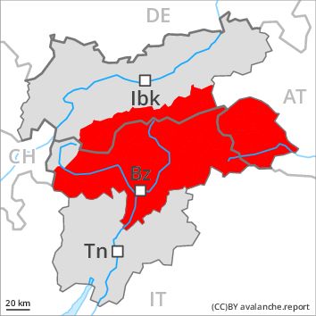
Danger level
Danger Level 4 - High
Avalanche Problem
Gliding snow above 2500m, N-NE-E-SE-S-SW-W-NW
Wind-drifted snow above 2000m, N-NE-E-SE-S-SW-W-NW
Numerous large and, in many cases, very large natural avalanches are to be expected as the precipitation becomes more intense. A critical avalanche situation will prevail.
As the precipitation becomes more intense numerous natural avalanches are to be expected, even very large ones. Gliding avalanches and dry slab avalanches are the main danger. On steep grassy slopes numerous medium-sized and large gliding avalanches are to be expected below approximately 2500 m. In the regions where a lot of rain falls the danger will increase more quickly.
As a consequence of warming, the likelihood of dry slab avalanches being released will increase appreciably. Numerous large and, in many cases, very large avalanches are to be expected, this applies in particular from early morning. The prevalence of avalanche prone locations and likelihood of triggering will increase with altitude.
Additionally in some places dry avalanches can also be released in near-ground layers and reach very large size as the day progresses. This applies in all aspects in high Alpine regions.
Outside marked and open pistes a critical avalanche situation will prevail.
Snowpack
dp 2: gliding snow
dp 6: cold, loose snow and wind
Over a wide area 50 to 80 cm of snow, and up to 120 cm in some localities, fell. Over a wide area 50 to 80 cm of snow, and even more in some localities, will fall above approximately 1500 m, especially in the east. The wind will be strong to storm force. As a consequence of fresh snow and a storm force southerly wind, extensive wind slabs will form in all aspects.
The snowpack will be generally prone to triggering. Over a wide area fresh snow and wind slabs are lying on soft layers, especially above approximately 2000 m. The old snowpack will be unstable in high Alpine regions. Dry avalanches can be released in near-ground layers.
The snowpack will become wet all the way through at low and intermediate altitudes.
Tendency
Gradual decrease in avalanche danger.
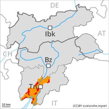
Regions
Latemar, Southern Adamello, Primiero - Pale di S. Martino, Adamello - Presanella, Northern Brenta - Peller, Vallarsa, Western Nonsberg Alps, Folgaria - Laverone, Southern Brenta, Fassa Valley, Sole, Pejo and Rabbi, Southern Lagorai, Northern Lagorai, Maddalene, Marzola - Valsugana, Pine' - Mocheni Valley
Danger level
Danger Level 4 - High
Avalanche Problem
Gliding snow above 2500m, N-NE-E-SE-S-SW-W-NW
Wind-drifted snow above 2000m, N-NE-E-SE-S-SW-W-NW
Numerous large and, in many cases, very large natural avalanches are to be expected as the precipitation becomes more intense. A critical avalanche situation will prevail.
As the precipitation becomes more intense numerous natural avalanches are to be expected, even very large ones. Gliding avalanches and dry slab avalanches are the main danger. On steep grassy slopes numerous medium-sized and large gliding avalanches are to be expected below approximately 2500 m. In the regions where a lot of rain falls the danger will increase more quickly.
As a consequence of warming, the likelihood of dry slab avalanches being released will increase appreciably. Numerous large and, in many cases, very large avalanches are to be expected, this applies in particular from early morning. The prevalence of avalanche prone locations and likelihood of triggering will increase with altitude.
Additionally in some places dry avalanches can also be released in near-ground layers and reach very large size as the day progresses. This applies in all aspects in high Alpine regions.
Outside marked and open pistes a critical avalanche situation will prevail.
Snowpack
dp 2: gliding snow
dp 6: cold, loose snow and wind
Over a wide area 50 to 80 cm of snow, and up to 120 cm in some localities, fell. Over a wide area 50 to 80 cm of snow, and even more in some localities, will fall above approximately 1500 m, especially in the east. The wind will be strong to storm force. As a consequence of fresh snow and a storm force southerly wind, extensive wind slabs will form in all aspects.
The snowpack will be generally prone to triggering. Over a wide area fresh snow and wind slabs are lying on soft layers, especially above approximately 2000 m. The old snowpack will be unstable in high Alpine regions. Dry avalanches can be released in near-ground layers.
The snowpack will become wet all the way through at low and intermediate altitudes.
Tendency
Gradual decrease in avalanche danger.
Regions
Western Tuxer Alps, Karwendel Mountains, Eastern Tuxer Alps, Western Kitzbühel Alps, Glockturm Range, Val Müstair Alps, Langtaufers, Northern Oetz and Stubai Alps
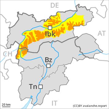
Danger level
Danger Level 3 - Considerable above 2000m
Danger Level 2 - Moderate above 2000m
Avalanche Problem
Wind-drifted snow above 2000m, N-NE-E-SE-S-SW-W-NW
Gliding snow above 2500m, N-NE-E-SE-S-SW-W-NW
Fresh wind slabs above approximately 2000 m. Gliding avalanches and snow slides below approximately 2500 m.
The fresh wind slabs represent the main danger. These are to be evaluated with care and prudence in all aspects above approximately 2000 m. At elevated altitudes the prevalence and size of the avalanche prone locations will increase on Sunday. As a consequence of warming, the likelihood of slab avalanches being released will increase.
In addition a certain danger of gliding avalanches and snow slides exists, in the regions exposed to a lot of fresh snow especially, in the regions exposed to rain this also applies.
Snowpack
dp 6: cold, loose snow and wind
dp 2: gliding snow
As a consequence of a strong to storm force southerly wind, wind slabs formed since Thursday at elevated altitudes. From the second half of the night the previously small wind slabs will increase in size additionally. In some places wind slabs are lying on soft layers, especially above approximately 2000 m. The snowpack will become wet all the way through at low and intermediate altitudes.
Tendency
Gradual decrease in avalanche danger.
Regions
Western Verwall Mountains, Eastern Verwall Mountains, Silvretta, Samnaun Mountains
Danger level
Danger Level 2 - Moderate above 2000m
Danger Level 2 - Moderate above 2000m
Avalanche Problem
Wind-drifted snow above 2000m, N-NE-E-W-NW
Gliding snow above 2500m, N-NE-E-SE-S-SW-W-NW
Fresh wind slabs above approximately 2000 m. Gliding avalanches and snow slides below approximately 2500 m.
The fresh wind slabs represent the main danger. These are to be evaluated with care and prudence in particular on west to north to east facing aspects above approximately 2000 m. At elevated altitudes the prevalence and size of the avalanche prone locations will increase on Sunday. As a consequence of warming, the likelihood of slab avalanches being released will increase.
In addition a certain danger of gliding avalanches and snow slides exists, in the regions exposed to heavier precipitation especially, in the regions exposed to rain this also applies.
Snowpack
dp 6: cold, loose snow and wind
dp 2: gliding snow
As a consequence of a strong to storm force southerly wind, wind slabs formed since Thursday at elevated altitudes. From the second half of the night the previously small wind slabs will increase in size additionally. In some places wind slabs are lying on soft layers, especially above approximately 2000 m. The snowpack will become wet all the way through at low and intermediate altitudes.
Tendency
Gradual decrease in avalanche danger.
Regions
Brandenberg Alps, Wilder Kaiser Mountains - Waidring Alps, Eastern Kitzbühel Alps, Western Lechtal Alps, Central Lechtal Alps, Grieskogel Mountains, Allgäu Alps, Eastern Lechtal Alps - Ammergau Alps, Mieming Mountains
Danger level
Danger Level 2 - Moderate above 2000m
Danger Level 1 - Low above 2000m
Avalanche Problem
Wind-drifted snow above 2000m, N-NE-NW
Gliding snow above 2500m, N-NE-E-SE-S-SW-W-NW
Fresh wind slabs above the tree line. Gliding avalanches and snow slides below approximately 2500 m.
The fresh wind slabs represent the main danger. These can be released in particular on northwest to north to northeast facing aspects above approximately 2000 m. They are mostly small.
Slides can occur on steep grassy slopes, in the regions exposed to heavier precipitation especially.
Snowpack
dp 6: cold, loose snow and wind
dp 2: gliding snow
As a consequence of a strong to storm force southerly wind, mostly small wind slabs formed since Thursday above the tree line. From the second half of the night the wind slabs will increase in size moderately. In some places wind slabs are lying on soft layers, in particular above approximately 2000 m. The snowpack will become wet all the way through at low and intermediate altitudes.
Tendency
Gradual decrease in avalanche danger.