Regions
Sexten Dolomites, Eastern Pfunderer Mountains, Durreck Range, Western Rieserferner Mountains, Gurgler Range, Western Deferegger Alps, Central Stubai Alps, Ortler Range, Schnals Ridge, Northern Zillertal Alps, Southern Stubai Alps, Ulten Valley, Venediger Range, Southern Zillertal Alps and High Tauern, Eastern Rieserferner Mountains, Saldurn-Mastaun Ridge, Glockner Range, Texel Mountains, Gröden Dolomites, Eastern Deferegger Alps, Prags Dolomites, Schober Mountains, Western Pfunderer Mountains, Lienzer Dolomites
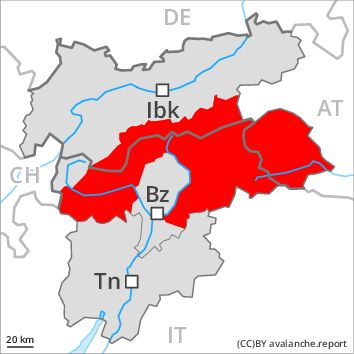
Danger level
Danger Level 4 - High
Avalanche Problem
Gliding snow above 2500m, N-NE-E-SE-S-SW-W-NW
Wind-drifted snow above 2200m, N-NE-E-SE-S-SW-W-NW

Gliding snow represents the main danger. Fresh wind slabs require caution, in particular above approximately 2200 m.
Numerous natural avalanches have been released as a consequence of fresh snow and stormy weather.
On steep grassy slopes more gliding avalanches are possible, even quite large ones, in the regions exposed to heavier precipitation especially, in particular in the east.
In addition the extensive wind slabs of the last few days above approximately 2200 m are prone to triggering. These can be released, even by a single winter sport participant and reach large size in isolated cases. The prevalence of avalanche prone locations and likelihood of triggering will increase with altitude. As a consequence of the sometimes strong southerly wind more natural avalanches are possible, even very large ones in isolated cases, in particular in shady places that are protected from the wind at high altitudes and in high Alpine regions.
Snow sport activities outside marked and open pistes call for extensive experience in the assessment of avalanche danger.
Snowpack
dp 2: gliding snow
dp 6: cold, loose snow and wind
Over a wide area 50 to 80 cm of snow, and up to 120 cm in some localities, fell. The wind was strong to storm force. In some places wind slabs are lying on soft layers, especially at elevated altitudes. The fresh wind slabs are in many cases thick and can in some cases be released easily especially at their margins. The snowpack will be wet all the way through at low and intermediate altitudes.
Tendency
The avalanche danger will persist.
Regions
Western Tuxer Alps, Karwendel Mountains, Eastern Tuxer Alps, Western Kitzbühel Alps, Eastern Kitzbühel Alps, Western Verwall Mountains, Eastern Verwall Mountains, Silvretta, Samnaun Mountains, Northern Oetz and Stubai Alps
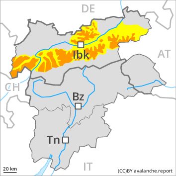
Danger level
Danger Level 3 - Considerable above 2200m
Danger Level 2 - Moderate above 2200m
Avalanche Problem
Wind-drifted snow above 2200m, N-NE-E-W-NW
Gliding snow above 2500m, N-NE-E-SE-S-SW-W-NW
Fresh wind slabs above approximately 2200 m. Gliding avalanches and moist snow slides.
The fresh wind slabs represent the main danger. These are sometimes thick and in some cases prone to triggering. They can be released in particular on west to north to east facing aspects above approximately 2200 m, especially at transitions from a shallow to a deep snowpack, when entering gullies and bowls for example.
On steep grassy slopes more gliding avalanches and snow slides are possible. In steep rocky terrain small wet loose snow avalanches are possible, in the regions exposed to heavier precipitation especially.
Snowpack
dp 6: cold, loose snow and wind
dp 2: gliding snow
As a consequence of a strong to storm force southerly wind, wind slabs formed in the last few days above the tree line. In some places wind slabs are lying on soft layers, in particular above approximately 2200 m. The snowpack will be wet all the way through at low and intermediate altitudes.
Tendency
Gradual decrease in avalanche danger.
Regions
Wilder Kaiser Mountains - Waidring Alps
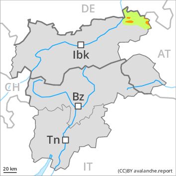
Danger level
Danger Level 3 - Considerable above 2200m
Danger Level 1 - Low above 2200m
Avalanche Problem
Wind-drifted snow above 2200m, N-NE-E-W-NW
Wet snow above 2200m, N-NE-E-SE-S-SW-W-NW
Fresh wind slabs above approximately 2200 m. Snow slides in particular on steep grassy slopes.
The fresh wind slabs represent the main danger. These can be released in particular on west to north to east facing aspects above approximately 2200 m. They are in some cases thick and in some cases prone to triggering.
Slides can occur on steep grassy slopes. In steep rocky terrain small wet loose snow avalanches are possible.
Snowpack
dp 6: cold, loose snow and wind
dp 2: gliding snow
As a consequence of a strong to storm force southerly wind, sometimes avalanche prone wind slabs formed in the last few days. In some places wind slabs are lying on soft layers, in particular above approximately 2200 m. The snowpack will be wet all the way through at low and intermediate altitudes.
Tendency
Further decrease in avalanche danger.
Regions
Sarntal Alps, Glockturm Range, Weißkugel Range, Val Müstair Alps, Langtaufers, Eastern Nonsberger Alps, Northern Dolomites of Fiemme
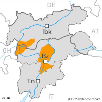
Danger level
Danger Level 3 - Considerable
Avalanche Problem
Wind-drifted snow above 2200m, N-NE-E-W-NW
Gliding snow above 2500m, N-NE-E-SE-S-SW-W-NW
Fresh wind slabs above approximately 2200 m. Gliding avalanches and moist snow slides.
The fresh wind slabs represent the main danger. These are sometimes thick and in some cases prone to triggering. They can be released in particular on west to north to east facing aspects above approximately 2200 m, especially at transitions from a shallow to a deep snowpack, when entering gullies and bowls for example.
On steep grassy slopes more gliding avalanches and snow slides are possible. In steep rocky terrain small wet loose snow avalanches are possible, in the regions exposed to heavier precipitation especially.
Snowpack
dp 6: cold, loose snow and wind
dp 2: gliding snow
As a consequence of a strong to storm force southerly wind, wind slabs formed in the last few days. In some places wind slabs are lying on soft layers, in particular above approximately 2200 m. The snowpack will be wet all the way through at low and intermediate altitudes.
Tendency
Gradual decrease in avalanche danger.
Regions
Brandenberg Alps, Western Lechtal Alps, Central Lechtal Alps, Grieskogel Mountains, Allgäu Alps, Eastern Lechtal Alps - Ammergau Alps, Mieming Mountains

Danger level
Danger Level 2 - Moderate above 2200m
Danger Level 1 - Low above 2200m
Avalanche Problem
Wind-drifted snow above 2200m, N-NE-NW
Wet snow above 2200m, N-NE-E-SE-S-SW-W-NW
Fresh wind slabs above approximately 2200 m. Snow slides in particular on steep grassy slopes.
The fresh wind slabs represent the main danger. These can be released in particular on northwest to north to northeast facing aspects above approximately 2200 m. They are mostly small.
Slides can occur on steep grassy slopes. In steep rocky terrain small wet loose snow avalanches are possible, in the regions exposed to heavier precipitation especially.
Snowpack
dp 6: cold, loose snow and wind
dp 2: gliding snow
As a consequence of a strong to storm force southerly wind, rather small wind slabs formed in the last few days at elevated altitudes. In some places wind slabs are lying on soft layers, in particular above approximately 2200 m. The snowpack will be wet all the way through at low and intermediate altitudes.
Tendency
Further decrease in avalanche danger.