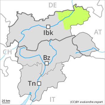
Regions
Western Lechtal Alps, Glockturm Range, Weißkugel Range, Western Verwall Mountains, Gurgler Range, Central Stubai Alps, Eastern Verwall Mountains, Allgäu Alps, Silvretta, Samnaun Mountains, Northern Oetz and Stubai Alps
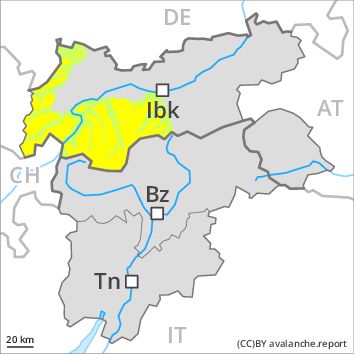
Danger level
Danger Level 2 - Moderate above 2400m
Danger Level 1 - Low above 2400m
Avalanche Problem
Wind-drifted snow above 2400m, N-NE-E-SE-S-SW-W-NW

Wind slabs above approximately 2400 m.
The fresh and older wind slabs are to be evaluated with care and prudence in all aspects at high altitudes and in high Alpine regions, in particular adjacent to ridgelines. Avalanches can be released, even by a single winter sport participant and reach medium size. The avalanche prone locations are clearly recognisable to the trained eye.
Apart from the danger of being buried, restraint should be exercised as well in view of the danger of avalanches sweeping people along and giving rise to falls.
Snowpack
dp 6: cold, loose snow and wind
In some regions up to 5 cm of snow. fell above approximately 1500 m. The sometimes storm force wind has transported the fresh and old snow. In some cases wind slabs are lying on soft layers. This applies in particular adjacent to ridgelines in all aspects especially above approximately 2400 m. The number and size of avalanche prone locations will increase with altitude.
Tendency
Increase in avalanche danger as a consequence of the fresh snow.
Regions
Sexten Dolomites, Val Müstair Alps, Langtaufers, Schnals Ridge, Southern Stubai Alps, Southern Zillertal Alps and High Tauern, Saldurn-Mastaun Ridge, Texel Mountains, Sarntal Alps, Western Pfunderer Mountains, Eastern Pfunderer Mountains, Durreck Range, Western Rieserferner Mountains, Western Deferegger Alps, Ortler Range, Northern Zillertal Alps, Ulten Valley, Venediger Range, Eastern Nonsberger Alps, Eastern Rieserferner Mountains, Northern Dolomites of Fiemme, Glockner Range, Gröden Dolomites, Eastern Deferegger Alps, Prags Dolomites, Schober Mountains, Lienzer Dolomites
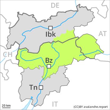
Danger level
Danger Level 1 - Low
Avalanche Problem
Wind-drifted snow above the treeline, N-NE-E-SE-S-NW
Fresh wind slabs are to be evaluated critically.
The fresh wind slabs must be evaluated with care and prudence in particular on northwest to north to south facing aspects, in particular adjacent to ridgelines. Skiers can release avalanches in some places. Avalanches are rather small. As a consequence of solar radiation individual small moist loose snow slides are possible. This applies especially on extremely steep sunny slopes. Apart from the danger of being buried, restraint should be exercised as well in view of the danger of avalanches sweeping people along and giving rise to falls. In addition a latent danger of gliding avalanches exists, in particular in case of releases originating from south facing starting zones below approximately 2600 m that have retained the snow thus far.
Snowpack
dp 6: cold, loose snow and wind
The fresh wind slabs remain in some cases prone to triggering. This applies at high altitudes and in high Alpine regions. The old snowpack will be moist on southeast, south and southwest facing slopes, in particular on steep sunny slopes below approximately 2600 m. The old snowpack will be generally well bonded.
Tendency
Slight warming above approximately 2000 m. The wind will be moderate. The avalanche danger will persist.
Regions
Prealps, Cembra Valley, Bondone and Stivo, Vallarsa, Western Nonsberg Alps, Folgaria - Laverone, Ledro Valley, Marzola - Valsugana, Pine' - Mocheni Valley
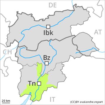
Danger level
Danger Level 1 - Low
Avalanche Problem
Gliding snow above 2200m above 1800m, SE-S-SW-W
In these regions the snowpack is well bonded. Ground avalanches are still possible in the second half of the day, especially on steep grassy slopes.
As a consequence of warming during the day and solar radiation individual gliding avalanches are possible, but they will be mostly small. The small wind slabs can be released, especially by large additional loads, in all aspects at elevated altitudes. Such avalanche prone locations are rare and are easy to recognise. Even in moderately steep terrain there is a danger of falling on the hard snow surface, after a clear night in particular.
Snowpack
dp 2: gliding snow
The snowpack will be in most cases stable. Over a wide area relatively hard layers of snow are lying on a moist old snowpack. At low and intermediate altitudes hardly any snow is lying.
Tendency
Low, level 1. Temporary increase in danger of gliding avalanches as a consequence of warming during the day and solar radiation.
Regions
Western Tuxer Alps, Karwendel Mountains, Eastern Tuxer Alps, Central Lechtal Alps, Grieskogel Mountains, Eastern Lechtal Alps - Ammergau Alps, Mieming Mountains

Danger level
Danger Level 1 - Low
Avalanche Problem
Wind-drifted snow above 2400m, N-NE-E-NW
A mostly favourable avalanche situation will be encountered over a wide area. Fresh wind slabs require caution.
The fresh wind slabs are in some cases prone to triggering in particular on northwest to north to east facing aspects above approximately 2400 m, in particular adjacent to ridgelines. They are clearly recognisable to the trained eye. Skiers can release avalanches in some places. These are rather small. Apart from the danger of being buried, restraint should be exercised as well in view of the danger of avalanches sweeping people along and giving rise to falls.
Snowpack
dp 6: cold, loose snow and wind
The old snowpack will be generally well bonded. As a consequence of a strong to storm force westerly wind, wind slabs formed in the last few days in particular adjacent to ridgelines. These are small but prone to triggering.
Tendency
Increase in avalanche danger as a consequence of the snowfall.
Regions
Southern Adamello, Primiero - Pale di S. Martino, Adamello - Presanella, Northern Brenta - Peller, Southern Brenta, Fassa Valley, Sole, Pejo and Rabbi, Southern Lagorai, Northern Lagorai, Latemar, Maddalene, Paganella
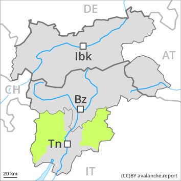
Danger level
Danger Level 1 - Low
Avalanche Problem
Wind-drifted snow above the treeline, N-NE-E-SE-S-SW-W-NW
Gliding snow above 2300m above 1600m, SE-S-SW-W
Caution is to be exercised in areas with glide cracks. Ground avalanches are still possible in particular in the second half of the day in isolated cases.
As a consequence of warming during the day and solar radiation individual gliding avalanches are possible, but they can reach medium size, especially at the base of rock walls and on steep grassy slopes below approximately 2400 m. Areas with glide cracks are to be avoided as far as possible. The mostly small wind slabs have bonded well with the old snowpack in all aspects. They are easy to recognise and can be released by large loads in particular, especially adjacent to ridgelines and in pass areas,, in isolated cases also in gullies and bowls, and behind abrupt changes in the terrain.
Snowpack
dp 2: gliding snow
dp 6: cold, loose snow and wind
The snowpack will be generally stable. The wind has transported only a little snow. The wind slabs are to be found in particular in the vicinity of peaks. These have bonded quite well with the old snowpack in all aspects. Over a wide area relatively hard layers of snow are lying on a moist old snowpack, in particular below the tree line as well as on sunny slopes at intermediate and high altitudes.
Tendency
Low, level 1. Temporary increase in danger of gliding avalanches as a consequence of warming during the day and solar radiation.
Regions
Brandenberg Alps, Western Kitzbühel Alps, Wilder Kaiser Mountains - Waidring Alps, Eastern Kitzbühel Alps
Danger level
Danger Level 1 - Low
Avalanche Problem
Favourable situation
The conditions are favourable.
Only a little snow is lying. On very steep shady slopes the avalanche prone locations are to be found adjacent to ridgelines and in gullies and bowls. They are rare and are easy to recognise. Avalanches can still in isolated cases be released, mostly by large loads.
A latent danger of gliding avalanches exists. This applies in particular in case of releases originating from south facing starting zones below approximately 2600 m that have retained the snow thus far.
Snowpack
No distinct weak layers exist in the snowpack in all altitude zones. The snowpack will be stable over a wide area. At low and intermediate altitudes hardly any snow is lying.
Tendency
Slight increase in avalanche danger as a consequence of the snowfall.