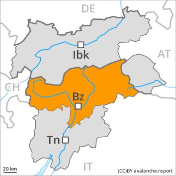
Regions
Sexten Dolomites, Eastern Pfunderer Mountains, Durreck Range, Val Müstair Alps, Western Rieserferner Mountains, Langtaufers, Western Deferegger Alps, Schnals Ridge, Ortler Range, Southern Stubai Alps, Ulten Valley, Southern Zillertal Alps and High Tauern, Eastern Nonsberger Alps, Saldurn-Mastaun Ridge, Northern Dolomites of Fiemme, Texel Mountains, Gröden Dolomites, Sarntal Alps, Prags Dolomites, Western Pfunderer Mountains

Danger level
Avalanche Problem
Gliding snow above 2400m, N-NE-E-SE-S-SW-W-NW
New snow, N-NE-E-SE-S-SW-W-NW

The snow sport conditions outside marked and open pistes are dangerous.
As the precipitation becomes more intense dry and wet avalanches are possible during the night, in particular medium-sized ones, in the regions exposed to heavier precipitation in particular on wind-loaded slopes and. Especially below approximately 2400 m small and medium-sized gliding avalanches are to be expected. From high-altitude starting zones in the regions exposed to precipitation the avalanches can in isolated cases reach fairly large size and in some places endanger transportation routes that are exposed. Single winter sport participants can release avalanches very easily. Ski touring and other off-piste activities, including snowshoe hiking, call for extensive experience in the assessment of avalanche danger and careful route selection.
Snowpack
As a consequence of fresh snow and a strong to storm force southwesterly wind, extensive wind slabs formed in the last few days also in areas not adjacent to ridgelines. 20 to 40 cm of snow, and up to 50 cm in some localities, will fall in the next few hours above approximately 1700 m. By the middle of the day the wind slabs will increase in size additionally. Faceted weak layers exist in the old snowpack in particular adjacent to ridgelines. The old snowpack will be moist below approximately 2200 m.
Tendency
Once the snowfall has ended, the natural avalanche activity will appreciably decrease. There is a danger of gliding avalanches, especially in the regions with a lot of snow in particular below approximately 2200 m.