Regions
Sexten Dolomites, Val Müstair Alps, Langtaufers, Schnals Ridge, Southern Stubai Alps, Southern Zillertal Alps and High Tauern, Saldurn-Mastaun Ridge, Texel Mountains, Sarntal Alps, Western Pfunderer Mountains, Eastern Pfunderer Mountains, Durreck Range, Western Rieserferner Mountains, Western Deferegger Alps, Ortler Range, Ulten Valley, Eastern Nonsberger Alps, Eastern Rieserferner Mountains, Northern Dolomites of Fiemme, Glockner Range, Gröden Dolomites, Eastern Deferegger Alps, Prags Dolomites, Schober Mountains, Lienzer Dolomites
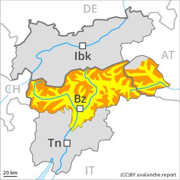
Danger level
Avalanche Problem
Wind-drifted snow above the treeline, N-NE-E-SE-S-SW-W-NW
Gliding snow above 2400m, N-NE-E-SE-S-SW-W-NW
![]()
The wind slabs represent the main danger.
The current avalanche situation calls for experience in the assessment of avalanche danger and careful route selection. Great caution and restraint are advisable. The more recent wind slabs are extensive and can be released easily. A few natural avalanches are to be expected, in particular on wind-loaded slopes. Especially below approximately 2400 m small and medium-sized gliding avalanches are possible.
Snowpack
dp 6: cold, loose snow and wind
dp 2: gliding snow
Some snow will fall in particular in the north and in the west. 10 to 20 cm of snow, and even more in some localities, will fall. As a consequence of the strong to storm force northwesterly wind the prevalence and size of the avalanche prone locations will increase on Tuesday. The wind slabs are to be found in particular adjacent to ridgelines and in gullies and bowls in all aspects as well as at high altitudes and in the high Alpine regions. The wind slabs have bonded poorly with the old snowpack. Faceted weak layers exist in the old snowpack in particular adjacent to ridgelines. The old snowpack will be moist below approximately 2200 m.
Tendency
Further increase in avalanche danger as a consequence of fresh snow and strong wind. This applies in particular in the regions exposed to heavier precipitation in the regions neighbouring those that are subject to danger level 4 (high). The northwesterly wind will transport the fresh and old snow. Wind slabs represent the main danger. There is a danger of gliding avalanches, in particular in the regions with a lot of snow in particular below approximately 2200 m.