Regions
Weißkugel Range, Western Verwall Mountains, Gurgler Range, Central Stubai Alps, Eastern Verwall Mountains, Allgäu Alps, Silvretta, Samnaun Mountains, Eastern Lechtal Alps - Ammergau Alps, Northern Oetz and Stubai Alps, Mieming Mountains, Karwendel Mountains, Western Lechtal Alps, Central Lechtal Alps, Glockturm Range, Grieskogel Mountains
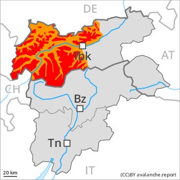
Danger level
Danger Level 4 - High above the treeline
Danger Level 3 - Considerable above the treeline
Avalanche Problem
New snow above the treeline, N-NE-E-SE-S-SW-W-NW

Above the tree line a very critical avalanche situation will be encountered over a wide area.
The backcountry and freeriding conditions are very critical. The fresh snow and wind slabs are very prone to triggering, in particular in shady places that are protected from the wind above the tree line as well as in areas close to the tree line. Avalanches can in many places be released very easily and reach dangerously large size. Natural avalanches are possible. The danger exists primarily in alpine snow sports terrain. Avalanches capable of reaching valley bottoms and endangering exposed transportation routes are unlikely to occur.
Snowpack
dp 5: snowfall after a long period of cold
dp 6: cold, loose snow and wind
Over a wide area 20 to 40 cm of snow. will fall in the next few hours. In particular in the Allgäu Alps, in the Western Lechtal Alps and in the Verwall Mountains 50 to 70 cm of snow. will fall. The wind will be strong to storm force over a wide area.
Faceted weak layers exist in the snowpack in particular on shady slopes. Over a wide area fresh snow and wind slabs are lying on a weakly bonded old snowpack. This applies especially in places that are protected from the wind in areas close to the tree line as well as on wind-protected west, north and east facing slopes above the tree line. In some places fresh snow is lying on surface hoar, in particular in places that are protected from the wind in areas close to the tree line.
Tendency
Outside marked and open pistes a critical avalanche situation will prevail.
Regions
Eastern Pfunderer Mountains, Durreck Range, Val Müstair Alps, Western Rieserferner Mountains, Langtaufers, Schnals Ridge, Ortler Range, Northern Zillertal Alps, Southern Stubai Alps, Venediger Range, Southern Zillertal Alps and High Tauern, Eastern Rieserferner Mountains, Saldurn-Mastaun Ridge, Western Tuxer Alps, Glockner Range, Texel Mountains, Eastern Tuxer Alps, Brandenberg Alps, Western Kitzbühel Alps, Wilder Kaiser Mountains - Waidring Alps, Western Pfunderer Mountains, Eastern Kitzbühel Alps
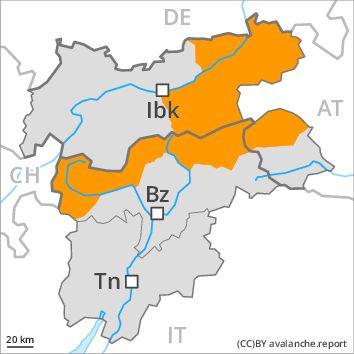
Danger level
Danger Level 3 - Considerable
Avalanche Problem
New snow, N-NE-E-SE-S-SW-W-NW
Fresh snow and wind slabs in all aspects.
The backcountry and freeriding conditions are critical. In the regions neighbouring those that are subject to danger level 4 (high) a very critical avalanche situation will be encountered in some localities.
As a consequence of fresh snow and a strong to storm force northwesterly wind, extensive wind slabs will form in particular in the regions exposed to heavier precipitation. The fresh snow will be deposited on soft layers in all aspects above the tree line. Fresh snow and wind slabs can in many places be released very easily and reach medium size. Natural avalanches are possible. In isolated cases avalanches can also be released in the old snowpack and reach quite a large size in particular on very steep shady slopes.
Snowpack
dp 5: snowfall after a long period of cold
dp 6: cold, loose snow and wind
The snowpack will be subject to considerable local variations. In some places relatively hard layers of snow are lying on old snow containing large grains, in particular adjacent to ridgelines as well as on wind-loaded slopes.
20 to 40 cm of snow. will fall in the next few hours. The sometimes storm force wind will transport the fresh and old snow. The fresh snow and wind slabs will be deposited on the unfavourable surface of an old snowpack in particular on shady slopes above the tree line. In some places fresh snow is lying on surface hoar. Caution is to be exercised in particular in places that are protected from the wind and in areas close to the tree line.
Tendency
Thursday: Hardly any decrease in avalanche danger.
Regions
Sexten Dolomites, Western Deferegger Alps, Ulten Valley, Gröden Dolomites, Southern Adamello, Eastern Deferegger Alps, Prags Dolomites, Sarntal Alps, Adamello - Presanella, Schober Mountains, Lienzer Dolomites, Sole, Pejo and Rabbi, Maddalene
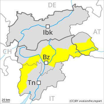
Danger level
Danger Level 2 - Moderate
Avalanche Problem
Wind-drifted snow, N-NE-E-SE-S-SW-W-NW
Fresh wind slabs require caution.
As a consequence of fresh snow and strong wind the wind slabs will increase in size until the early morning. The prevalence of avalanche prone locations and likelihood of triggering will increase. The fresh wind slabs can be released by a single winter sport participant in some cases in particular on steep shady slopes. From origins in starting zones at higher altitudes dry slab avalanches are possible, but they will be mostly small. They can be released in the weakly bonded old snow in particular in areas where the snow cover is rather shallow.
Snowpack
dp 5: snowfall after a long period of cold
dp 6: cold, loose snow and wind
Over a wide area 5 to 15 cm of snow. will fall in the next few hours in all altitude zones. The strong wind will transport the fresh snow. Especially above the tree line sometimes easily released wind slabs will form. The fresh snow and wind slabs will be deposited on a weakly bonded old snowpack in particular on shady slopes. Faceted weak layers exist in the old snowpack especially here.
Tendency
Hardly any decrease in avalanche danger. The wind will be strong over a wide area.
Regions
Primiero - Pale di S. Martino, Northern Brenta - Peller, Western Nonsberg Alps, Southern Brenta, Fassa Valley, Northern Lagorai, Latemar, Eastern Nonsberger Alps, Northern Dolomites of Fiemme
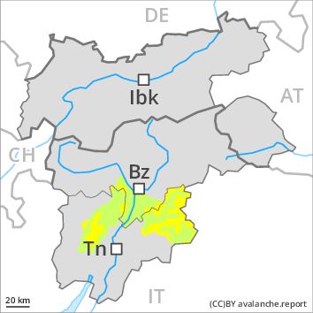
Danger level
Danger Level 2 - Moderate above the treeline
Danger Level 1 - Low above the treeline
Avalanche Problem
Wind-drifted snow above the treeline, N-NE-E-SE-S-NW
Fresh wind slabs are to be evaluated with care and prudence.
As a consequence of fresh snow and strong wind the wind slabs will increase in size additionally. Mostly avalanches are only small but in many cases easily released. At high altitudes and in high Alpine regions avalanche prone locations are a little more prevalent. Adjacent to ridgelines avalanches can be triggered in deep layers of the snowpack and reach medium size in some cases. Restraint should be exercised because avalanches can sweep people along and give rise to falls. In steep terrain there is a danger of falling on the hard snow surface.
Snowpack
dp 6: cold, loose snow and wind
Over a wide area 5 to 10 cm of snow. has fallen since yesterday above approximately 1000 m. The strong wind will transport the fresh snow significantly. Especially above the tree line sometimes easily released wind slabs will form. The fresh snow and wind slabs will be deposited on a weakly bonded old snowpack in particular on shady slopes. Faceted weak layers exist in the old snowpack especially here.
Tendency
The wind will be strong over a wide area. Wind slabs require caution.
Regions
Prealps, Cembra Valley, Bondone and Stivo, Vallarsa, Folgaria - Laverone, Southern Lagorai, Ledro Valley, Paganella, Marzola - Valsugana, Pine' - Mocheni Valley

Danger level
Danger Level 1 - Low
Avalanche Problem
Wind-drifted snow above the treeline, N-NE-E-SE-S-NW
Fresh wind slabs are to be evaluated with care and prudence.
As a consequence of fresh snow and strong wind the wind slabs will increase in size additionally. Mostly avalanches are only small but in many cases easily released. At high altitudes and in high Alpine regions avalanche prone locations are a little more prevalent. Adjacent to ridgelines avalanches can be triggered in deep layers of the snowpack and reach medium size in some cases. Restraint should be exercised because avalanches can sweep people along and give rise to falls. In steep terrain there is a danger of falling on the hard snow surface.
Snowpack
dp 6: cold, loose snow and wind
Over a wide area 2 to 5 cm of snow. has fallen since yesterday above approximately 1000 m. The strong wind will transport only a little snow. In particular adjacent to ridgelines and in pass areas mostly small wind slabs will form. The fresh snow and wind slabs will be deposited on a weakly bonded old snowpack in particular on shady slopes. Faceted weak layers exist in the old snowpack especially here.
Tendency
The wind will be strong over a wide area. Wind slabs require caution. The conditions are mostly favourable for snow sport activities outside marked and open pistes.