Regions
Eastern Pfunderer Mountains, Durreck Range, Weißkugel Range, Western Rieserferner Mountains, Val Müstair Alps, Gurgler Range, Langtaufers, Central Stubai Alps, Ortler Range, Schnals Ridge, Northern Zillertal Alps, Southern Stubai Alps, Venediger Range, Southern Zillertal Alps and High Tauern, Northern Oetz and Stubai Alps, Eastern Rieserferner Mountains, Saldurn-Mastaun Ridge, Western Tuxer Alps, Glockner Range, Texel Mountains, Eastern Tuxer Alps, Western Pfunderer Mountains, Glockturm Range, Grieskogel Mountains
Danger level
Avalanche Problem
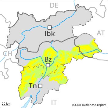
New snow, N-NE-E-SE-S-SW-W-NW
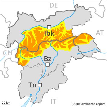
Wind-drifted snow, N-NE-E-W-NW
![]()
Fresh snow and wind slabs in all aspects.
The backcountry and freeriding conditions remain to some extent unfavourable. As a consequence of fresh snow and a strong to storm force northwesterly wind, extensive wind slabs formed in particular in the regions exposed to heavier precipitation. It is lying on soft layers in particular on west to north to east facing aspects above the tree line. Fresh snow and wind slabs can in some places be released, even by a single winter sport participant and reach medium size. These avalanche prone locations are covered with fresh snow and are therefore barely recognisable, even to the trained eye.
Whumpfing sounds and the formation of shooting cracks when stepping on the snowpack can indicate the danger. In highly frequented off-piste terrain and below the tree line the situation is a little more favourable.
Significant warming to high altitudes: As a consequence of warming, the likelihood of loose snow avalanches being released will increase significantly on very steep sunny slopes. In addition as the day progresses an increasing number of mostly small natural dry avalanches are possible. A latent danger of gliding avalanches exists, in particular on steep grassy slopes below approximately 2200 m.
Snowpack
dp 5: snowfall after a long period of cold
dp 6: cold, loose snow and wind
The snowpack will be subject to considerable local variations above the tree line, in particular adjacent to ridgelines. The fresh snow and wind slabs are lying on soft layers, especially on wind-protected shady slopes above the tree line as well as in areas close to the tree line. In some places relatively hard layers of snow are lying on old snow containing large grains.
Tendency
Outside marked and open pistes a sometimes unfavourable avalanche situation will prevail.