Regions
Sexten Dolomites, Latemar, Western Deferegger Alps, Ulten Valley, Eastern Nonsberger Alps, Eastern Rieserferner Mountains, Northern Dolomites of Fiemme, Glockner Range, Gröden Dolomites, Southern Adamello, Eastern Deferegger Alps, Prags Dolomites, Sarntal Alps, Adamello - Presanella, Schober Mountains, Northern Brenta - Peller, Lienzer Dolomites, Western Nonsberg Alps, Southern Brenta, Fassa Valley, Sole, Pejo and Rabbi, Maddalene
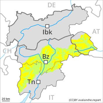
Danger level
Danger Level 2 - Moderate above the treeline
Danger Level 1 - Low above the treeline
Avalanche Problem
Wind-drifted snow above the treeline, N-NE-E-SE-NW
Wet snow above 2600m, SE-S-SW-W

The danger of dry and wet avalanches will increase a little during the day.
The more recent wind slabs can still be released in particular on steep shady slopes above the tree line. As a consequence of warming during the day small and, in isolated cases, medium-sized moist and wet avalanches are possible. They can be released in the weakly bonded old snow in particular in areas where the snow cover is rather shallow. In particular transitions from a shallow to a deep snowpack where weaknesses exist in the old snowpack are precarious.
Snowpack
The strong wind will transport the loosely bonded old snow. In particular above the tree line mostly small wind slabs will form. Large-grained weak layers exist in the snowpack especially on steep, rather lightly snow-covered shady slopes. At high altitudes and in high Alpine regions the avalanche prone locations are more prevalent.
Tendency
The wind will be strong to storm force over a wide area.
Regions
Primiero - Pale di S. Martino, Prealps, Cembra Valley, Bondone and Stivo, Vallarsa, Folgaria - Laverone, Southern Lagorai, Ledro Valley, Northern Lagorai, Paganella, Marzola - Valsugana, Pine' - Mocheni Valley
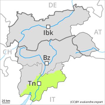
Danger level
Danger Level 1 - Low
Avalanche Problem
Wet snow above 2000m, SE-S-SW-W
Wind-drifted snow above the treeline, N-NE-E-SE-S-NW
The danger of dry and wet avalanches will increase a little during the day.
Fresh and somewhat older wind slabs are mostly rather small and can be released by large loads in particular. At high altitudes and in high Alpine regions avalanche prone locations are a little more prevalent. A clear night will be followed in the early morning by quite favourable conditions generally, but the danger of wet and gliding avalanches will increase later. Moist avalanches can be released in near-ground layers in particular in areas where the snow cover is rather shallow. In steep terrain there is a danger of falling on the hard crust.
Snowpack
The snowpack will be in most cases well bonded. Adjacent to ridgelines and in gullies and bowls mostly small wind slabs formed. The strong wind will transport only a little snow. Faceted weak layers exist in the old snowpack in particular on rather lightly snow-covered shady slopes. At high altitudes and in high Alpine regions the avalanche prone locations are more prevalent.
Tendency
The wind will be moderate to strong at times over a wide area.