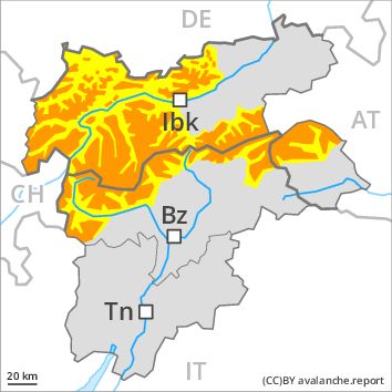
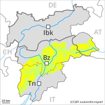
Regions
Val Müstair Alps, Western Verwall Mountains, Langtaufers, Eastern Verwall Mountains, Schnals Ridge, Silvretta, Southern Stubai Alps, Samnaun Mountains, Southern Zillertal Alps and High Tauern, Northern Oetz and Stubai Alps, Saldurn-Mastaun Ridge, Texel Mountains, Glockturm Range, Durreck Range, Weißkugel Range, Western Rieserferner Mountains, Gurgler Range, Central Stubai Alps, Ortler Range, Northern Zillertal Alps, Allgäu Alps, Venediger Range, Eastern Lechtal Alps - Ammergau Alps, Mieming Mountains, Eastern Rieserferner Mountains, Karwendel Mountains, Glockner Range, Western Lechtal Alps, Central Lechtal Alps, Grieskogel Mountains

Danger level
Avalanche Problem
Wind-drifted snow above the treeline, N-NE-E-SE-S-SW-W-NW
Wet snow above the treeline, N-NE-E-SE-S-SW-W-NW

Increase in danger of dry avalanches as a consequence of fresh snow and stormy weather.
As a consequence of the snowfall, the likelihood of dry avalanches being released will increase appreciably especially above the tree line. Especially in places where the wind is storm force the avalanche danger is greater. The number and size of avalanche prone locations will increase as the day progresses. The avalanche prone locations are to be found in particular on wind-loaded slopes of all aspects. They will increase with altitude. The brittle wind slabs will be covered with fresh snow in some cases and therefore difficult to recognise.
In addition as the day progresses still more individual wet and gliding avalanches are possible. This applies in particular in starting zones below the tree line that have retained the snow thus far.
Snowpack
dp 6: cold, loose snow and wind
dp 2: gliding snow
Over a wide area persistent snowfall to low altitudes. 30 to 50 cm of snow. will fall. The northwesterly wind will transport the fresh snow significantly. As a consequence of fresh snow and a storm force to violent wind from northwesterly directions, brittle wind slabs will form in all aspects. These will be deposited on soft layers.
Tendency
The avalanche danger will persist.
