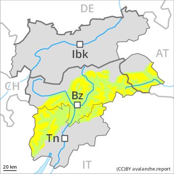
Regions
Val Müstair Alps, Western Verwall Mountains, Langtaufers, Eastern Verwall Mountains, Schnals Ridge, Silvretta, Southern Stubai Alps, Samnaun Mountains, Southern Zillertal Alps and High Tauern, Northern Oetz and Stubai Alps, Saldurn-Mastaun Ridge, Western Tuxer Alps, Texel Mountains, Eastern Tuxer Alps, Western Kitzbühel Alps, Eastern Kitzbühel Alps, Glockturm Range, Durreck Range, Weißkugel Range, Western Rieserferner Mountains, Gurgler Range, Central Stubai Alps, Ortler Range, Northern Zillertal Alps, Allgäu Alps, Venediger Range, Eastern Lechtal Alps - Ammergau Alps, Mieming Mountains, Eastern Rieserferner Mountains, Karwendel Mountains, Glockner Range, Brandenberg Alps, Wilder Kaiser Mountains - Waidring Alps, Western Lechtal Alps, Central Lechtal Alps, Grieskogel Mountains
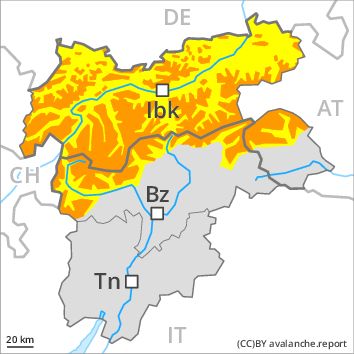
Danger level
Avalanche Problem
Wind-drifted snow above the treeline, N-NE-E-SE-S-SW-W-NW
![]()
The backcountry and freeriding conditions remain to some extent critical. Wind slabs represent the main danger.
As a consequence of fresh snow and a storm force to violent wind, extensive wind slabs formed in the last three days especially in gullies and bowls and behind abrupt changes in the terrain. Even single winter sport participants can release avalanches in many places, including dangerously large ones.
As a consequence of solar radiation individual natural loose snow slides are possible. This applies in particular on extremely steep sunny slopes.
Snowpack
dp 6: cold, loose snow and wind
dp 9: graupel blanketed with snow
The snowpack will be subject to considerable local variations. Since Tuesday extensive wind slabs formed in particular above the tree line. In some cases the various wind slabs have bonded still only poorly together. The old snowpack will be wet all the way through below approximately 2300 m.
Tendency
Gradual decrease in avalanche danger.