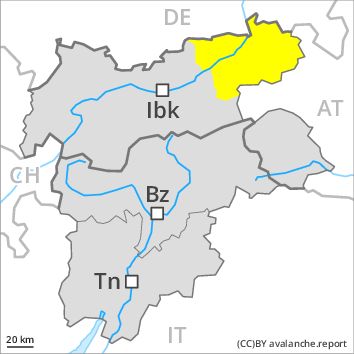
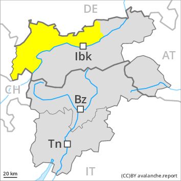
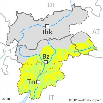
Regions
Brandenberg Alps, Western Kitzbühel Alps, Wilder Kaiser Mountains - Waidring Alps, Eastern Kitzbühel Alps
AM
Danger level
Danger Level 2 - Moderate above the treeline
Danger Level 2 - Moderate above the treeline
Avalanche Problem
Wind-drifted snow above the treeline, N-NE-NW
PM
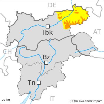
Danger level
Danger Level 3 - Considerable above the treeline
Danger Level 2 - Moderate above the treeline
Avalanche Problem
Wind-drifted snow, N-NE-E-SE-S-SW-W-NW
Wet snow above the treeline, N-NE-E-SE-S-SW-W-NW
Increase in avalanche danger as a consequence of fresh snow and stormy weather.
The avalanche danger will increase during the day.
As a consequence of fresh snow and a strong to storm force wind, sometimes avalanche prone wind slabs will form in all aspects, especially on shady slopes as well as adjacent to ridgelines and in gullies and bowls. The number and size of avalanche prone locations will increase as the day progresses.
From midday as a consequence of the rain there will be an increase in the danger of gliding avalanches and snow slides. This applies at low and intermediate altitudes.
Snowpack
dp 6: cold, loose snow and wind
dp 3: rain
The fresh wind slabs are bonding poorly with the old snowpack in particular on shady slopes.
Up to intermediate altitudes rain will fall from midday over a wide area. Over a wide area 10 to 20 cm of snow. will fall. This applies at high altitudes and in high Alpine regions.
The wind will be storm force.
Tendency
Fresh wind slabs represent the main danger.
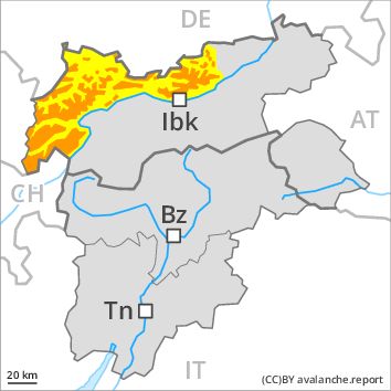
Regions
Western Tuxer Alps, Eastern Tuxer Alps, Glockturm Range, Grieskogel Mountains, Weißkugel Range, Gurgler Range, Central Stubai Alps, Northern Zillertal Alps, Venediger Range, Northern Oetz and Stubai Alps
AM
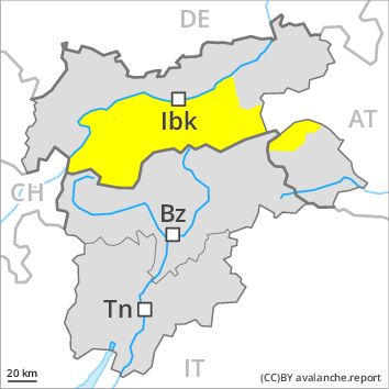
Danger level
Danger Level 2 - Moderate above the treeline
Danger Level 2 - Moderate above the treeline
Avalanche Problem
Persistent weak layer above 2800m above 2300m, N-NE-E-W-NW
Wind-drifted snow, N-NE-E-W-NW
PM
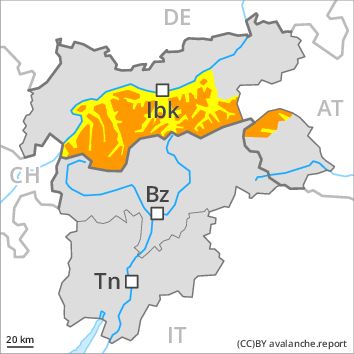
Danger level
Danger Level 3 - Considerable above the treeline
Danger Level 2 - Moderate above the treeline
Avalanche Problem
Wind-drifted snow above the treeline, N-NE-E-SE-S-SW-W-NW
Persistent weak layer above 2800m above 2300m, N-NE-E-W-NW
Increase in avalanche danger as a consequence of fresh snow and stormy weather.
The avalanche danger will increase during the day.
As a consequence of fresh snow and a strong to storm force wind, sometimes avalanche prone wind slabs will form in all aspects, especially on shady slopes as well as adjacent to ridgelines and in gullies and bowls. The number and size of avalanche prone locations will increase as the day progresses.
Weakly bonded old snow requires caution. These avalanche prone locations are to be found in particular on very steep west, north and east facing slopes between approximately 2300 and 2800 m. Caution is to be exercised in particular at transitions from a shallow to a deep snowpack in little used backcountry terrain. Avalanches can be released by large loads and reach large size in isolated cases.
From midday as a consequence of the rain there will be only a slight increase in the danger of gliding avalanches and snow slides. This applies at low and intermediate altitudes.
Snowpack
dp 6: cold, loose snow and wind
dp 7: snow-poor zones in snow-rich surrounding
The fresh wind slabs are bonding poorly with the old snowpack in particular on shady slopes.
Up to intermediate altitudes rain will fall from midday over a wide area. Over a wide area 10 cm of snow, and even more in some localities, will fall. This applies at high altitudes and in high Alpine regions.
The wind will be storm force.
Faceted weak layers exist in the old snowpack in particular on west, north and east facing slopes, in particular between approximately 2300 and 2800 m, especially in little used backcountry terrain. The snowpack will be subject to considerable local variations.
Tendency
Fresh wind slabs represent the main danger. Weakly bonded old snow requires caution.
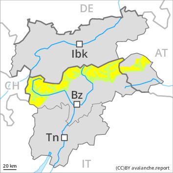
Regions
Karwendel Mountains, Western Lechtal Alps, Central Lechtal Alps, Western Verwall Mountains, Eastern Verwall Mountains, Allgäu Alps, Silvretta, Samnaun Mountains, Eastern Lechtal Alps - Ammergau Alps, Mieming Mountains
AM
Danger level
Danger Level 2 - Moderate above the treeline
Danger Level 2 - Moderate above the treeline
Avalanche Problem
Persistent weak layer above 2800m above 2300m, N-NE-E-W-NW
Wind-drifted snow, N-NE-E-W-NW
PM
Danger level
Danger Level 3 - Considerable above the treeline
Danger Level 2 - Moderate above the treeline
Avalanche Problem
Wind-drifted snow above the treeline, N-NE-E-SE-S-SW-W-NW
Wet snow above the treeline, N-NE-E-SE-S-SW-W-NW
Increase in avalanche danger as a consequence of fresh snow and stormy weather.
The avalanche danger will increase during the day.
As a consequence of fresh snow and a strong to storm force wind, sometimes avalanche prone wind slabs will form in all aspects, especially on shady slopes as well as adjacent to ridgelines and in gullies and bowls. The number and size of avalanche prone locations will increase as the day progresses.
From midday as a consequence of the rain there will be an increase in the danger of gliding avalanches and snow slides. This applies at low and intermediate altitudes.
Weakly bonded old snow requires caution. These avalanche prone locations are to be found in particular on very steep west, north and east facing slopes between approximately 2300 and 2800 m. Caution is to be exercised in particular at transitions from a shallow to a deep snowpack in little used backcountry terrain. Avalanches can be released by large loads and reach large size in isolated cases.
Snowpack
dp 6: cold, loose snow and wind
dp 3: rain
The fresh wind slabs are bonding poorly with the old snowpack in particular on shady slopes.
Up to intermediate altitudes rain will fall from midday over a wide area. Over a wide area 10 to 20 cm of snow. will fall. This applies at high altitudes and in high Alpine regions.
The wind will be storm force.
Faceted weak layers exist in the old snowpack in particular on west, north and east facing slopes, in particular between approximately 2300 and 2800 m, especially in little used backcountry terrain. The snowpack will be subject to considerable local variations.
Tendency
Fresh wind slabs represent the main danger. Weakly bonded old snow requires caution.
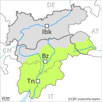
Regions
Eastern Pfunderer Mountains, Durreck Range, Val Müstair Alps, Western Rieserferner Mountains, Langtaufers, Schnals Ridge, Ortler Range, Southern Stubai Alps, Southern Zillertal Alps and High Tauern, Eastern Rieserferner Mountains, Saldurn-Mastaun Ridge, Glockner Range, Texel Mountains, Western Pfunderer Mountains
Danger level
Danger Level 2 - Moderate above the treeline
Danger Level 1 - Low above the treeline
Avalanche Problem
Wind-drifted snow above the treeline, N-NE-E-SE-S-SW-W-NW
Persistent weak layer above 2800m above 2300m, N-NE-E-W-NW

Fresh wind slabs at high altitudes and in high Alpine regions. Weakly bonded old snow requires caution.
Fresh wind slabs represent the main danger. As a consequence of fresh snow and a sometimes storm force westerly wind, sometimes avalanche prone wind slabs will form as the day progresses in all aspects, in particular adjacent to ridgelines and in gullies and bowls at high altitudes and in high Alpine regions.
Weakly bonded old snow: The avalanche prone locations for dry avalanches are to be found in particular on very steep west, north and east facing slopes between approximately 2300 and 2800 m. Caution is to be exercised in particular at transitions from a shallow to a deep snowpack in little used backcountry terrain. Avalanches can be released by large loads and reach large size in isolated cases.
In addition there is a danger of gliding avalanches and wet snow slides. These avalanche prone locations are to be found in particular on steep grassy slopes below approximately 2000 m, in the event of rain especially in the regions with a lot of snow.
In steep terrain there is a danger of falling on the hard snow surface.
Snowpack
dp 6: cold, loose snow and wind
dp 3: rain
In some regions wind and fresh snow: Up to 10 cm of snow, and even more in some localities, will fall from midday above approximately 2000 m. The fresh wind slabs will become increasingly prone to triggering above the tree line.
Faceted weak layers exist in the old snowpack in particular on west, north and east facing slopes. This applies in particular between approximately 2300 and 2800 m, especially in little used backcountry terrain.
The snowpack will be subject to considerable local variations.
Tendency
The avalanche danger will persist. Fresh wind slabs are to be evaluated with care and prudence.
Regions
Sexten Dolomites, Latemar, Southern Adamello, Sarntal Alps, Adamello - Presanella, Northern Brenta - Peller, Bondone and Stivo, Folgaria - Laverone, Southern Brenta, Southern Lagorai, Northern Lagorai, Maddalene, Pine' - Mocheni Valley, Western Deferegger Alps, Ulten Valley, Eastern Nonsberger Alps, Northern Dolomites of Fiemme, Gröden Dolomites, Primiero - Pale di S. Martino, Eastern Deferegger Alps, Prags Dolomites, Prealps, Schober Mountains, Cembra Valley, Lienzer Dolomites, Vallarsa, Western Nonsberg Alps, Fassa Valley, Sole, Pejo and Rabbi, Ledro Valley, Paganella, Marzola - Valsugana
AM
Danger level
Danger Level 1 - Low above the treeline
Danger Level 1 - Low above the treeline
PM
Danger level
Danger Level 2 - Moderate above the treeline
Danger Level 1 - Low above the treeline
Avalanche Problem
Wind-drifted snow above the treeline, N-NE-E-SE-NW
The backcountry and freeriding conditions are generally favourable. Fresh wind slabs represent the main danger.
Fresh wind slabs require caution. The avalanche prone locations are to be found in particular on very steep shady slopes above approximately 1800 m and adjacent to ridgelines. These places are rare and are clearly recognisable to the trained eye. The avalanches are rather small. In addition a low (level 1) danger of moist snow slides exists. In the event of rain this applies. In steep terrain there is a danger of falling on the hard snow surface.
Snowpack
dp 6: cold, loose snow and wind
The fresh wind slabs are in some cases prone to triggering in particular on very steep shady slopes above the tree line. These are mostly small. The wind will be storm force. The older wind slabs have bonded well with the old snowpack. The snowpack will be subject to considerable local variations.
Tendency
The avalanche danger will persist. Fresh wind slabs require caution.