Regions
Eastern Pfunderer Mountains, Durreck Range, Weißkugel Range, Western Rieserferner Mountains, Val Müstair Alps, Gurgler Range, Langtaufers, Central Stubai Alps, Ortler Range, Schnals Ridge, Northern Zillertal Alps, Southern Stubai Alps, Venediger Range, Southern Zillertal Alps and High Tauern, Northern Oetz and Stubai Alps, Mieming Mountains, Saldurn-Mastaun Ridge, Western Tuxer Alps, Karwendel Mountains, Texel Mountains, Eastern Tuxer Alps, Western Pfunderer Mountains, Glockturm Range, Grieskogel Mountains
Danger level
Avalanche Problem
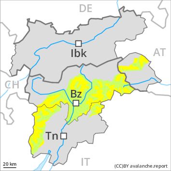
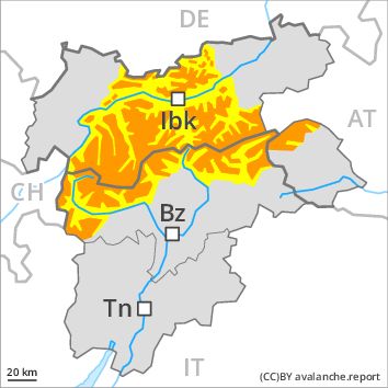
Wind-drifted snow above the treeline, N-NE-E-SE-S-SW-W-NW
Persistent weak layer above 2900m above 1800m, N-NE-E-W-NW
![]()
The fresh wind slabs must be evaluated with care and prudence in all aspects in all altitude zones.
As a consequence of fresh snow and a strong to storm force wind, extensive wind slabs will form in all aspects, caution is to be exercised in particular on shady slopes as well as adjacent to ridgelines and in gullies and bowls especially above the tree line, also in areas close to the tree line on very steep slopes. The wind slabs can be released easily, even by a single winter sport participant,. The prevalence of avalanche prone locations and likelihood of triggering will increase with altitude.
In the regions exposed to heavier precipitation individual natural dry avalanches are possible, in particular medium-sized ones, in particular on wind-loaded slopes adjacent to ridgelines at high altitudes and in high Alpine regions.
Weakly bonded old snow requires caution. These avalanche prone locations are to be found in particular on very steep west, north and east facing slopes between approximately 2300 and 2900 m. Caution is to be exercised in particular at transitions from a shallow to a deep snowpack in little used backcountry terrain. Avalanches can be released, in particular by large loads and reach large size in isolated cases. Individual avalanche prone locations are to be found also between approximately 1800 and 2300 m, in particular on very steep shady slopes.
In addition a certain danger of gliding avalanches exists. This applies on steep grassy slopes in particular at low and intermediate altitudes.
Snowpack
dp 6: cold, loose snow and wind
dp 4: cold following warm / warm following cold
Over a wide area 10 to 20 cm of snow, and even more in some localities, will fall. The wind will be strong to storm force. The fresh wind slabs are bonding poorly with the old snowpack in particular on shady slopes. This applies at high altitudes and in high Alpine regions.
Faceted weak layers exist in the old snowpack, in particular between approximately 2300 and 2900 m, especially in little used backcountry terrain, also between approximately 1800 and 2300 m on northwest, north and northeast facing slopes. The snowpack will be subject to considerable local variations.
Tendency
Backcountry touring and other off-piste activities call for experience in the assessment of avalanche danger.