Regions
Texel Mountains, Durreck Range, Val Müstair Alps, Langtaufers, Schnals Ridge, Southern Stubai Alps, Southern Zillertal Alps and High Tauern, Saldurn-Mastaun Ridge
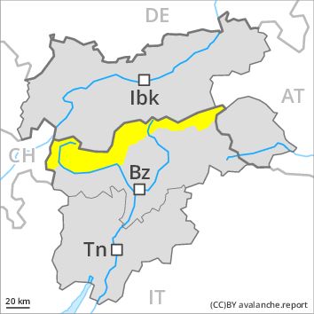
Danger level
Danger Level 2 - Moderate above 2200m
Danger Level 2 - Moderate above 2200m
Avalanche Problem
Wind-drifted snow above 2200m, N-NE-E-NW
Persistent weak layer above 2800m, SE-S-SW-W

Fresh and older wind slabs require caution.
Fresh and somewhat older wind slabs can be released by a single winter sport participant in some cases in particular on very steep shady slopes above approximately 2200 m. These avalanche prone locations are clearly recognisable to the trained eye. Weakly bonded old snow requires caution. Caution is to be exercised in particular at transitions from a shallow to a deep snowpack in little used backcountry terrain. In isolated cases the avalanches can be triggered in the weakly bonded old snow and reach quite a large size. The danger of moist and wet avalanches will increase during the day. In addition a certain danger of gliding avalanches exists.
Snowpack
dp 6: cold, loose snow and wind
dp 2: gliding snow
The wind slabs of the last few days have bonded quite well with the old snowpack. Faceted weak layers exist in the old snowpack. The snowpack will be subject to considerable local variations. Outgoing longwave radiation during the night will be reduced in some case. The surface of the snowpack will already soften in the late morning.
Tendency
The weather will be very mild.
Regions
Gröden Dolomites, Prags Dolomites, Sarntal Alps, Western Pfunderer Mountains, Sexten Dolomites, Eastern Pfunderer Mountains, Western Rieserferner Mountains, Western Deferegger Alps, Ortler Range, Ulten Valley, Eastern Nonsberger Alps, Northern Dolomites of Fiemme
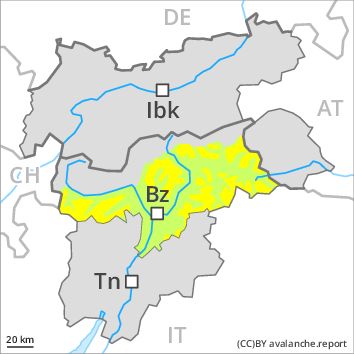
Danger level
Danger Level 2 - Moderate above 2200m
Danger Level 1 - Low above 2200m
Avalanche Problem
Wind-drifted snow above 2200m, N-NE-E-NW
Wet snow above 2600m, SE-S-SW-W
Dry slab avalanches and moist snow slides during the day are possible.
Fresh wind slabs require caution. The avalanche prone locations are to be found especially on very steep northeast, north and southeast facing slopes above approximately 2200 m, especially in gullies and bowls, and behind abrupt changes in the terrain. These places are clearly recognisable to the trained eye. Mostly the avalanches are small.
In steep terrain there is a danger of falling on the hard snow surface.
As a consequence of warming during the day and solar radiation moist and wet avalanches are possible. This applies in particular in case of releases originating from very steep, sunny starting zones below approximately 2600 m that have retained the snow thus far.
Snowpack
dp 6: cold, loose snow and wind
The somewhat older wind slabs are mostly small. In very isolated cases relatively hard layers of snow are lying on old snow containing large grains. This applies especially on shady slopes at high altitudes and in high Alpine regions. The snowpack will be subject to considerable local variations.
Tendency
The avalanche danger will persist. The weather will be very mild.