Regions
Val Müstair Alps, Western Verwall Mountains, Langtaufers, Eastern Verwall Mountains, Schnals Ridge, Silvretta, Southern Stubai Alps, Samnaun Mountains, Southern Zillertal Alps and High Tauern, Northern Oetz and Stubai Alps, Saldurn-Mastaun Ridge, Western Tuxer Alps, Texel Mountains, Eastern Tuxer Alps, Glockturm Range, Durreck Range, Weißkugel Range, Western Rieserferner Mountains, Gurgler Range, Central Stubai Alps, Ortler Range, Northern Zillertal Alps, Venediger Range, Eastern Rieserferner Mountains, Glockner Range, Grieskogel Mountains
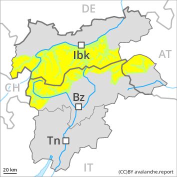
Danger level
Danger Level 2 - Moderate above 2200m
Danger Level 1 - Low above 2200m
Avalanche Problem
Wind-drifted snow above 2200m, N-NE-E-SE-NW

Fresh wind slabs require caution.
Fresh and somewhat older wind slabs can be released by a single winter sport participant in some cases in particular on northwest to north to southeast facing aspects above approximately 2200 m. In some cases avalanches are medium-sized. In high Alpine regions avalanche prone locations are more prevalent. These avalanche prone locations are clearly recognisable to the trained eye.
Weakly bonded old snow: In very isolated cases avalanches can be released in the old snowpack and reach dangerously large size in particular on very steep shady slopes. Caution is to be exercised in particular at transitions from a shallow to a deep snowpack in little used backcountry terrain, in isolated cases also in areas close to the tree line.
As a consequence of warming during the day, the likelihood of dry and moist snow slides being released will increase a little on rocky sunny slopes.
Snowpack
dp 6: cold, loose snow and wind
As the day progresses mostly small wind slabs will form in particular in gullies and bowls and behind abrupt changes in the terrain. Faceted weak layers exist in the old snowpack. The snowpack will be subject to considerable local variations. On south and southwest facing slopes a little snow is lying at low and intermediate altitudes. In steep terrain there is a danger of falling on the hard snow surface.
Tendency
The backcountry touring conditions are generally favourable. Fresh and older wind slabs require caution.
Regions
Karwendel Mountains, Brandenberg Alps, Western Lechtal Alps, Central Lechtal Alps, Allgäu Alps, Eastern Lechtal Alps - Ammergau Alps, Mieming Mountains
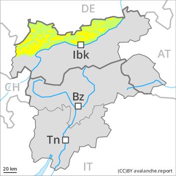
Danger level
Danger Level 2 - Moderate above the treeline
Danger Level 1 - Low above the treeline
Avalanche Problem
Wind-drifted snow above the treeline, N-NE-E-SE-NW
Above the tree line: Fresh wind slabs require caution. In some regions light rain to the tree line.
The wind will be strong to storm force in the vicinity of peaks. Fresh and somewhat older wind slabs can be released by a single winter sport participant in some cases in particular on northwest to north to southeast facing aspects above the tree line. In some cases avalanches are medium-sized. In high Alpine regions avalanche prone locations are more prevalent. These avalanche prone locations are clearly recognisable to the trained eye.
Weakly bonded old snow: In very isolated cases avalanches can be released in the old snowpack and reach dangerously large size in particular on little-used, rather lightly snow-covered shady slopes. Caution is to be exercised in particular at transitions from a shallow to a deep snowpack in little used backcountry terrain, in isolated cases also in areas close to the tree line. These avalanche prone locations are very rare and are difficult to recognise.
Below the tree line: As a consequence of the rain, the likelihood of moist and wet snow slides being released will increase a little.
Snowpack
dp 6: cold, loose snow and wind
In some regions light rain to the tree line. Above the tree line: Up to 5 cm of snow. will fall.
In the last few days mostly small wind slabs formed in particular in gullies and bowls and behind abrupt changes in the terrain. Faceted weak layers exist in the old snowpack. The snowpack will be subject to considerable local variations. On south and southwest facing slopes a little snow is lying at low and intermediate altitudes. In steep terrain there is a danger of falling on the hard snow surface.
Tendency
Fresh and older wind slabs require caution.
Regions
Southern Adamello, Primiero - Pale di S. Martino, Adamello - Presanella, Northern Brenta - Peller, Southern Brenta, Fassa Valley, Sole, Pejo and Rabbi, Southern Lagorai, Northern Lagorai, Latemar, Maddalene, Pine' - Mocheni Valley
AM
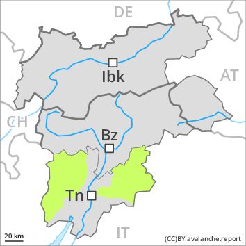
Danger level
Danger Level 1 - Low above 1800m
Danger Level 1 - Low above 1800m
Avalanche Problem
Wind-drifted snow above 2400m, N-NE-E-SE-NW
PM
Danger level
Danger Level 2 - Moderate above 1800m
Danger Level 1 - Low above 1800m
Avalanche Problem
Wet snow above 2600m above 1800m, E-SE-S-SW-W
Wind-drifted snow above 2400m, N-NE-E-SE-NW
The backcountry touring conditions in the morning, after a clear night, are mostly favourable.
The rather small wind slabs have bonded quite well with the old snowpack. These can only be released by large loads in most cases. The avalanche prone locations are to be found in particular on steep northwest to north to southeast facing slopes above approximately 2400 m, especially in gullies and bowls, and behind abrupt changes in the terrain. These places are clearly recognisable to the trained eye.
In steep terrain there is a danger of falling on the icy crust. The early morning will see quite favourable conditions generally, but the danger of wet and gliding avalanches will increase later. This applies in particular on steep grassy slopes and at the base of rock walls below approximately 2600 m.
Snowpack
The fresh and somewhat older wind slabs are mostly small and can only be released in isolated cases. In some cases relatively hard layers of snow are lying on old snow containing large grains. Faceted weak layers exist deep in the snowpack in particular on shady slopes. The snowpack will be subject to considerable local variations. The surface of the snowpack will freeze to form a strong crust only at high altitudes and will soften earlier than the day before. Below approximately 2000 m only a little snow is lying on south and southwest facing slopes.
Tendency
Temporary increase in danger of gliding avalanches and moist snow slides as a consequence of warming during the day.
Regions
Prealps, Cembra Valley, Bondone and Stivo, Vallarsa, Western Nonsberg Alps, Folgaria - Laverone, Ledro Valley, Paganella, Marzola - Valsugana
AM

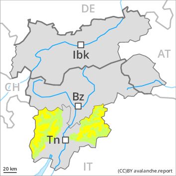
Danger level
Danger Level 1 - Low
Avalanche Problem
Favourable situation above 1800m
PM
Danger level
Danger Level 1 - Low
Avalanche Problem
Wet snow above 1800m, E-SE-S-SW-W
The snowpack will be generally well bonded.
In steep terrain there is a danger of falling on the hard snow surface. The rather small wind slabs have bonded quite well with the old snowpack. These can only be released by large loads in most cases. The avalanche prone locations are to be found in particular on steep northwest to north to southeast facing slopes, especially in gullies and bowls, and behind abrupt changes in the terrain. These places are clearly recognisable to the trained eye.
The early morning will see quite favourable conditions generally, but the avalanche danger will increase later. In particular on steep grassy slopes individual small and, in isolated cases, medium-sized natural moist avalanches are possible.
Snowpack
dp 10: springtime scenario
The fresh and somewhat older wind slabs are mostly small and can only be released in isolated cases. In some cases relatively hard layers of snow are lying on old snow containing large grains. Faceted weak layers exist deep in the snowpack in particular on shady slopes. The snowpack will be subject to considerable local variations. The surface of the snowpack will freeze to form a strong crust only at high altitudes and will soften earlier than the day before. On south and southwest facing slopes a little snow is lying in all altitude zones.
Tendency
The backcountry touring conditions in the morning, after a clear night, are mostly favourable.
Regions
Sexten Dolomites, Eastern Pfunderer Mountains, Western Deferegger Alps, Ulten Valley, Eastern Nonsberger Alps, Northern Dolomites of Fiemme, Gröden Dolomites, Eastern Deferegger Alps, Prags Dolomites, Sarntal Alps, Schober Mountains, Western Pfunderer Mountains, Lienzer Dolomites
Danger level
Danger Level 1 - Low
Avalanche Problem
Wind-drifted snow above 2400m, N-NE-E-SE-NW
The backcountry touring conditions are favourable over a wide area.
The rather small wind slabs have bonded quite well with the old snowpack. These can only be released by large loads in most cases. The avalanche prone locations are to be found in particular on northwest to north to southeast facing wind-loaded slopes above approximately 2400 m, especially in gullies and bowls, and behind abrupt changes in the terrain. These places are clearly recognisable to the trained eye.
In steep terrain there is a danger of falling on the hard snow surface.
Snowpack
dp 6: cold, loose snow and wind
The fresh and somewhat older wind slabs are mostly small and can only be released in isolated cases. In some cases relatively hard layers of snow are lying on old snow containing large grains. Faceted weak layers exist deep in the snowpack in particular on shady slopes. The snowpack will be subject to considerable local variations. On south and southwest facing slopes a little snow is lying in all altitude zones.
Tendency
The backcountry touring conditions are generally favourable.
Regions
Western Kitzbühel Alps, Wilder Kaiser Mountains - Waidring Alps, Eastern Kitzbühel Alps
Danger level
Danger Level 1 - Low
Avalanche Problem
Wind-drifted snow above the treeline, N-NE-E-SE-NW
Above the tree line: Fresh wind slabs require caution. In some regions light rain to the tree line.
The wind will be strong to storm force in the vicinity of peaks. In the last few days small wind slabs formed in particular adjacent to ridgelines. This applies in particular at elevated altitudes. In high Alpine regions avalanche prone locations are a little more prevalent. These avalanche prone locations are clearly recognisable to the trained eye.
Weakly bonded old snow: In very isolated cases avalanches can be released in the old snowpack and reach dangerously large size in particular on little-used, rather lightly snow-covered shady slopes. Caution is to be exercised in particular at transitions from a shallow to a deep snowpack in little used backcountry terrain, in isolated cases also in areas close to the tree line. These avalanche prone locations are very rare and are difficult to recognise.
Below the tree line: As a consequence of the rain, the likelihood of moist and wet snow slides being released will increase a little.
Snowpack
dp 6: cold, loose snow and wind
In some regions light rain to the tree line. Above the tree line: Up to 5 cm of snow. will fall.
In the last few days mostly small wind slabs formed in particular in gullies and bowls and behind abrupt changes in the terrain. Faceted weak layers exist in the old snowpack. The snowpack will be subject to considerable local variations. On south and southwest facing slopes a little snow is lying at low and intermediate altitudes. In steep terrain there is a danger of falling on the hard snow surface.
Tendency
Fresh and older wind slabs require caution.