Regions
Val Müstair Alps, Western Verwall Mountains, Langtaufers, Eastern Verwall Mountains, Schnals Ridge, Silvretta, Southern Stubai Alps, Samnaun Mountains, Southern Zillertal Alps and High Tauern, Northern Oetz and Stubai Alps, Saldurn-Mastaun Ridge, Western Tuxer Alps, Texel Mountains, Eastern Tuxer Alps, Western Kitzbühel Alps, Eastern Kitzbühel Alps, Glockturm Range, Durreck Range, Weißkugel Range, Western Rieserferner Mountains, Gurgler Range, Central Stubai Alps, Ortler Range, Northern Zillertal Alps, Allgäu Alps, Venediger Range, Eastern Lechtal Alps - Ammergau Alps, Mieming Mountains, Karwendel Mountains, Brandenberg Alps, Wilder Kaiser Mountains - Waidring Alps, Western Lechtal Alps, Central Lechtal Alps, Grieskogel Mountains
Danger level
Avalanche Problem
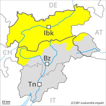
Wind-drifted snow above 2200m, N-NE-E-SE-NW
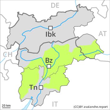
Wet snow above 2200m, N-NE-E-SE-S-SW-W-NW
![]()
Above approximately 2200 m: Wind slabs require caution.
The wind was strong to storm force over a wide area. The wind slabs can be released by a single winter sport participant in some cases in particular on northwest to north to southeast facing aspects above the tree line. In some cases avalanches are medium-sized. In high Alpine regions avalanche prone locations are more prevalent. These avalanche prone locations are clearly recognisable to the trained eye.
Weakly bonded old snow: In very isolated cases avalanches can be released in the old snowpack and reach dangerously large size in particular on little-used, rather lightly snow-covered shady slopes. Caution is to be exercised in particular at transitions from a shallow to a deep snowpack in little used backcountry terrain, in isolated cases also in areas close to the tree line. These avalanche prone locations are very rare and are difficult to recognise.
In the last few days the weather has been exceptionally warm. More small and, in isolated cases, medium-sized wet and gliding avalanches are possible below approximately 2200 m.
Snowpack
dp 6: cold, loose snow and wind
The snowpack will be subject to considerable local variations.
Below approximately 2200 m: The snowpack will be wet all the way through, especially on east, southeast and south facing slopes. On south and southwest facing slopes a little snow is lying at low and intermediate altitudes.
High altitudes and the high Alpine regions: In the last few days mostly small wind slabs formed in particular in gullies and bowls and behind abrupt changes in the terrain. Faceted weak layers exist in the old snowpack. There is a danger of falling on the hard snow surface.
Tendency
Increase in avalanche danger as a consequence of fresh snow and wind.