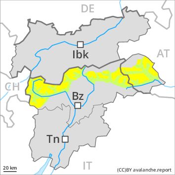
Regions
Karwendel Mountains, Western Lechtal Alps, Central Lechtal Alps, Western Verwall Mountains, Eastern Verwall Mountains, Allgäu Alps, Silvretta, Eastern Lechtal Alps - Ammergau Alps, Mieming Mountains
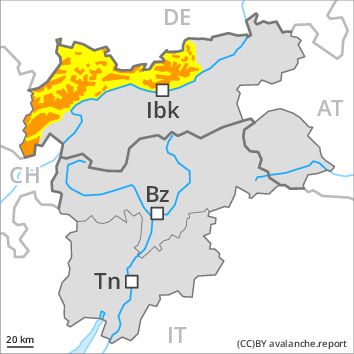
Danger level
Danger Level 3 - Considerable above the treeline
Danger Level 2 - Moderate above the treeline
Avalanche Problem
Wind-drifted snow above the treeline, N-NE-E-SE-S-SW-W-NW
New snow above the treeline, N-NE-E-SE-S-SW-W-NW

Fresh and older wind slabs require caution.
Fresh snow and much of the wind-drifted snow represent the main danger. As a consequence of fresh snow and a sometimes storm force wind, wind slabs formed in all aspects, in particular adjacent to ridgelines as well as in high Alpine regions. As a consequence of the sometimes storm force wind these will increase in size once again from the middle of the day. The wind slabs can be released by a single winter sport participant in some cases above the tree line. In some cases avalanches are medium-sized. In high Alpine regions avalanche prone locations are more prevalent.
Weakly bonded old snow: In very isolated cases avalanches can be released in the old snowpack and reach dangerously large size in particular on little-used, rather lightly snow-covered shady slopes. These avalanche prone locations are very rare and are difficult to recognise. Caution is to be exercised in particular at transitions from a shallow to a deep snowpack in little used backcountry terrain.
Snowpack
dp 6: cold, loose snow and wind
More snow than expected has fallen. Over a wide area 20 to 30 cm of snow, and even more in some localities, fell. Some snow will fall from midday. Over a wide area up to 10 cm of snow, and even more in some localities, will fall.
The snowpack will be subject to considerable local variations. High altitudes and the high Alpine regions: As a consequence of the sometimes strong wind the wind slabs will increase in size additionally. The fresh wind slabs are lying on soft layers. In some cases the various wind slabs have bonded poorly together. The older wind slabs of the last few days have bonded quite well with the old snowpack. Faceted weak layers exist deeper in the old snowpack.
Especially below approximately 2200 m: The snowpack will be moist in some places. The surface of the snowpack will freeze to form a strong crust.
Tendency
In some regions increase in avalanche danger as a consequence of the storm force to violent wind, in particular in the regions exposed to heavier precipitation.
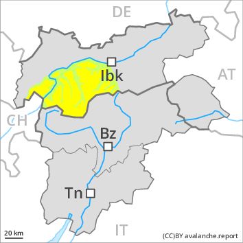
Regions
Wilder Kaiser Mountains - Waidring Alps, Eastern Kitzbühel Alps
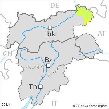
Danger level
Danger Level 2 - Moderate above the treeline
Danger Level 1 - Low above the treeline
Avalanche Problem
Wind-drifted snow above the treeline, N-NE-E-SE-S-SW-W-NW
Fresh wind slabs require caution.
The fresh and older wind slabs represent the main danger. As a consequence of a strengthening wind, mostly small wind slabs will form from the middle of the day. These are in isolated cases prone to triggering. The avalanche prone locations are to be found on steep slopes of all aspects, especially in gullies and bowls, and behind abrupt changes in the terrain. These places are clearly recognisable to the trained eye. As a consequence of the sometimes storm force westerly wind the prevalence of avalanche prone locations will increase from midday.
Only isolated gliding avalanches and moist snow slides are possible.
Snowpack
dp 6: cold, loose snow and wind
In some regions up to 10 cm of snow, and even more in some localities, fell. The snowpack will be subject to considerable local variations. The fresh snow will be deposited on the quite favourable surface of an old snowpack. The wind slabs are lying on soft layers, in particular in places that are protected from the wind. In some cases relatively hard layers of snow are lying on old snow containing large grains. Individual weak layers exist deep in the snowpack on shady slopes. At low altitude only a little snow is lying.
From the afternoon the wind will be strong to storm force adjacent to ridgelines.
Tendency
In some regions increase in avalanche danger as a consequence of the storm force wind.
Regions
Gröden Dolomites, Prags Dolomites, Sarntal Alps, Lienzer Dolomites, Sexten Dolomites, Ulten Valley, Eastern Nonsberger Alps, Northern Dolomites of Fiemme
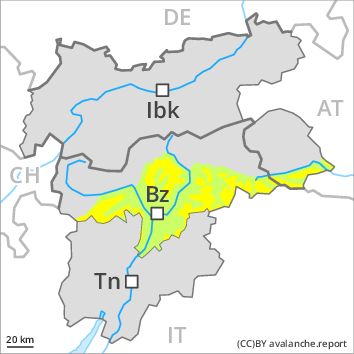
Danger level
Danger Level 2 - Moderate above the treeline
Danger Level 1 - Low above the treeline
Avalanche Problem
Wind-drifted snow above the treeline, N-NE-E-SE-S-SW-W-NW
Fresh wind slabs require caution.
As a consequence of fresh snow and a sometimes strong wind, mostly small wind slabs will form over a wide area. The various wind slabs have bonded quite well with the old snowpack. The avalanche prone locations are to be found on steep slopes of all aspects, especially in gullies and bowls, and behind abrupt changes in the terrain. The wind slabs are in isolated cases prone to triggering.
In many places there is a danger of falling on the hard snow surface.
Snowpack
dp 6: cold, loose snow and wind
In some regions up to 5 cm of snow. has fallen since yesterday. The fresh wind slabs are mostly small and can only be released in isolated cases. The snowpack will be subject to considerable local variations. The surface of the snowpack will freeze to form a strong crust. Individual weak layers exist deep in the snowpack on shady slopes. Below approximately 2000 m only a little snow is lying on south and southwest facing slopes.
Tendency
Slight increase in danger.
Regions
Western Tuxer Alps, Eastern Tuxer Alps, Brandenberg Alps, Western Kitzbühel Alps, Durreck Range, Northern Zillertal Alps, Southern Zillertal Alps and High Tauern, Venediger Range
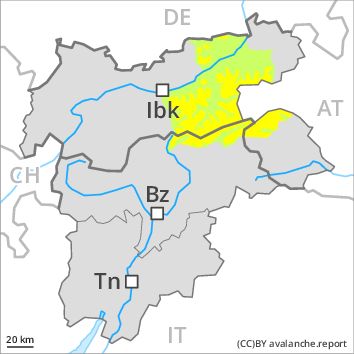
Danger level
Danger Level 2 - Moderate above the treeline
Danger Level 1 - Low above the treeline
Avalanche Problem
Wind-drifted snow above the treeline, N-NE-E-SE-S-SW-W-NW
Fresh wind slabs represent the main danger.
As a consequence of fresh snow and a strong wind, mostly small wind slabs will form over a wide area. The wind slabs can be released by a single winter sport participant in some cases in all aspects above the tree line. At elevated altitudes the avalanche prone locations are more prevalent. In some cases avalanches are medium-sized.
Afternoon: The wind will be storm force over a wide area. As a consequence of the wind the wind slabs will increase in size additionally.
In very isolated cases avalanches can be released in the old snowpack and reach dangerously large size in particular on little-used, rather lightly snow-covered shady slopes. These avalanche prone locations are very rare and are difficult to recognise.
Snowpack
dp 6: cold, loose snow and wind
In some regions up to 15 cm of snow, and even more in some localities, fell. The fresh snow will be deposited on a quite favourable old snowpack. The surface of the snowpack has frozen to form a strong crust. The snowpack will be subject to considerable local variations. As a consequence of the strong wind the wind slabs will increase in size additionally. Faceted weak layers exist in the old snowpack.
Tendency
As a consequence of fresh snow and wind there will be an increase in the danger.
Regions
Eastern Pfunderer Mountains, Western Rieserferner Mountains, Val Müstair Alps, Western Deferegger Alps, Langtaufers, Ortler Range, Schnals Ridge, Southern Stubai Alps, Saldurn-Mastaun Ridge, Eastern Rieserferner Mountains, Texel Mountains, Glockner Range, Eastern Deferegger Alps, Western Pfunderer Mountains, Schober Mountains
Danger level
Danger Level 2 - Moderate above the treeline
Danger Level 1 - Low above the treeline
Avalanche Problem
Wind-drifted snow above the treeline, N-NE-E-SE-S-SW-W-NW
Wind slabs require caution.
As a consequence of fresh snow and strong wind the wind slabs will increase in size additionally. The wind slabs are mostly small. They can be released by a single winter sport participant in some cases in all aspects above the tree line. At elevated altitudes the avalanche prone locations are more prevalent.
Weakly bonded old snow: To some extent avalanches can be released in the old snowpack and reach dangerously large size in particular on little-used, rather lightly snow-covered shady slopes. These avalanche prone locations are very rare and are difficult to recognise.
In many places there is a danger of falling on the hard snow surface.
Snowpack
dp 6: cold, loose snow and wind
Some snow has fallen in some regions. As a consequence of a sometimes strong wind, further wind slabs will form. In some cases the various wind slabs have bonded still only poorly together. The snowpack will be subject to considerable local variations. The surface of the snowpack has frozen to form a strong crust. Faceted weak layers exist in the old snowpack.
Tendency
As a consequence of fresh snow and wind there will be an increase in the danger.
Regions
Glockturm Range, Grieskogel Mountains, Weißkugel Range, Gurgler Range, Central Stubai Alps, Samnaun Mountains, Northern Oetz and Stubai Alps
Danger level
Danger Level 2 - Moderate above the treeline
Danger Level 1 - Low above the treeline
Avalanche Problem
Wind-drifted snow above the treeline, N-NE-E-SE-S-SW-W-NW
Fresh and older wind slabs require caution.
Fresh and older wind slabs represent the main danger. As a consequence of fresh snow and a sometimes storm force wind, wind slabs formed in all aspects, in particular adjacent to ridgelines as well as in high Alpine regions. As a consequence of the sometimes storm force wind these will increase in size once again from the middle of the day. The wind slabs can be released by a single winter sport participant in some cases above the tree line. In some cases avalanches are medium-sized. In high Alpine regions avalanche prone locations are more prevalent.
Weakly bonded old snow: In very isolated cases avalanches can be released in the old snowpack and reach dangerously large size in particular on little-used, rather lightly snow-covered shady slopes. These avalanche prone locations are very rare and are difficult to recognise. Caution is to be exercised in particular at transitions from a shallow to a deep snowpack in little used backcountry terrain.
Snowpack
dp 6: cold, loose snow and wind
Some snow will fall from midday. Over a wide area up to 10 cm of snow, and even more in some localities, will fall.
The snowpack will be subject to considerable local variations. High altitudes and the high Alpine regions: As a consequence of the sometimes strong wind the wind slabs will increase in size additionally. The fresh wind slabs are lying on soft layers. In some cases the various wind slabs have bonded poorly together. The older wind slabs of the last few days have bonded quite well with the old snowpack. Faceted weak layers exist deeper in the old snowpack.
Especially below approximately 2200 m: The snowpack will be moist in some places. The surface of the snowpack will freeze to form a strong crust.
Tendency
In some regions increase in avalanche danger as a consequence of the storm force to violent wind, in particular in the regions exposed to heavier precipitation.