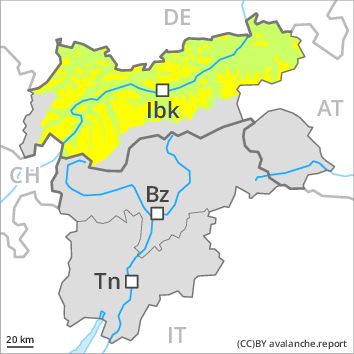
Regions
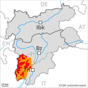
Southern Adamello, Adamello - Presanella, Northern Brenta - Peller, Southern Brenta, Sole, Pejo and Rabbi, Ledro Valley, Paganella
Danger level
Danger Level 4 - High above the treeline
Danger Level 3 - Considerable above the treeline
Avalanche Problem
Wind-drifted snow above the treeline, N-NE-E-SE-S-SW-W-NW
New snow, N-NE-E-SE-S-SW-W-NW

As a consequence of fresh snow and wind a critical avalanche situation will be encountered in some regions.
Wind slabs: As a consequence of fresh snow and a strong northerly wind, avalanche prone wind slabs will form above the tree line, in particular in gullies and bowls, and behind abrupt changes in the terrain at high altitudes and in high Alpine regions in all aspects. Even single winter sport participants can release avalanches easily, including large ones. A few natural avalanches are to be expected, in the regions exposed to a lot of wind in particular in the regions exposed to heavier precipitation and.
Gliding avalanches: In the regions exposed to heavier precipitation there will be a gradual increase in the danger of gliding avalanches, in particular on steep south facing slopes below approximately 2000 m.
Snowpack
dp 6: cold, loose snow and wind
Over a wide area 30 to 60 cm of snow, and up to 70 cm in some localities, will fall. The sometimes strong wind will transport the fresh snow. The fresh snow and wind slabs will be deposited on soft layers in all aspects. The snowpack will be subject to considerable local variations. Individual weak layers exist in the old snowpack in particular on steep shady slopes.
Tendency
Slight decrease in avalanche danger as a consequence of the ceasing of precipitation.
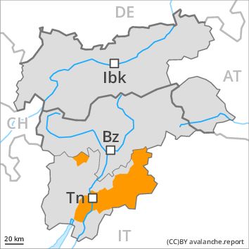
Regions
Texel Mountains, Prags Dolomites, Western Pfunderer Mountains, Sexten Dolomites, Ortler Range, Southern Stubai Alps, Ulten Valley, Southern Zillertal Alps and High Tauern

Danger level
Danger Level 3 - Considerable
Avalanche Problem
Wind-drifted snow above 1800m, N-NE-E-SE-S-SW-W-NW
New snow, N-NE-E-SE-S-SW-W-NW
As a consequence of fresh snow and wind a critical avalanche situation will be encountered in some regions.
Wind slabs: As a consequence of fresh snow and a strong northerly wind, avalanche prone wind slabs will form above the tree line, in particular in gullies and bowls, and behind abrupt changes in the terrain at high altitudes and in high Alpine regions in all aspects. Even single winter sport participants can release avalanches easily, including large ones. A few natural avalanches are to be expected, in the regions exposed to a lot of wind in particular in the regions exposed to heavier precipitation and.
Gliding avalanches: In the regions exposed to heavier precipitation there will be a gradual increase in the danger of gliding avalanches, in particular on steep south facing slopes below approximately 2000 m.
Snowpack
dp 6: cold, loose snow and wind
Over a wide area 20 to 40 cm of snow, and up to 50 cm in some localities, will fall. The sometimes strong wind will transport the fresh snow. The fresh snow and wind slabs will be deposited on soft layers in all aspects. The snowpack will be subject to considerable local variations. Individual weak layers exist in the old snowpack in particular on steep shady slopes.
Tendency
Slight decrease in avalanche danger as a consequence of the ceasing of precipitation.
Regions
Primiero - Pale di S. Martino, Bondone and Stivo, Fassa Valley, Southern Lagorai, Northern Lagorai, Maddalene, Marzola - Valsugana, Pine' - Mocheni Valley
Danger level
Danger Level 3 - Considerable
Avalanche Problem
Wind-drifted snow above 1800m, N-NE-E-SE-S-SW-W-NW
New snow, N-NE-E-SE-S-SW-W-NW
As a consequence of fresh snow and wind a critical avalanche situation will be encountered in some regions.
Wind slabs: As a consequence of fresh snow and a strong northerly wind, avalanche prone wind slabs will form above the tree line, in particular in gullies and bowls, and behind abrupt changes in the terrain at high altitudes and in high Alpine regions in all aspects. Even single winter sport participants can release avalanches easily, including large ones. A few natural avalanches are to be expected, in the regions exposed to a lot of wind in particular in the regions exposed to heavier precipitation and.
Gliding avalanches: In the regions exposed to heavier precipitation there will be a gradual increase in the danger of gliding avalanches, in particular on steep south facing slopes below approximately 2000 m.
Snowpack
dp 6: cold, loose snow and wind
Over a wide area 30 to 50 cm of snow, and up to 60 cm in some localities, will fall. The sometimes strong wind will transport the fresh snow. The fresh snow and wind slabs will be deposited on soft layers in all aspects. The snowpack will be subject to considerable local variations. Individual weak layers exist in the old snowpack in particular on steep shady slopes.
Tendency
Slight decrease in avalanche danger as a consequence of the ceasing of precipitation.
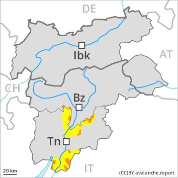
Regions
Prealps, Cembra Valley, Vallarsa, Western Nonsberg Alps, Folgaria - Laverone, Latemar
Danger level
Danger Level 3 - Considerable above the treeline
Danger Level 2 - Moderate above the treeline
Avalanche Problem
Wind-drifted snow above the treeline, N-NE-E-SE-S-SW-W-NW
New snow, N-NE-E-SE-S-SW-W-NW
As a consequence of fresh snow and wind a critical avalanche situation will be encountered in some regions.
Wind slabs: As a consequence of fresh snow and a strong northerly wind, avalanche prone wind slabs will form above the tree line, in particular in gullies and bowls, and behind abrupt changes in the terrain at high altitudes and in high Alpine regions in all aspects. Even single winter sport participants can release avalanches easily, including large ones. A few natural avalanches are to be expected, in the regions exposed to a lot of wind in particular in the regions exposed to heavier precipitation and.
Snowpack
dp 6: cold, loose snow and wind
Over a wide area 30 to 40 cm of snow, and even more in some localities, will fall, especially in the Dolomites. The sometimes strong wind will transport the fresh snow. The snowpack will be subject to considerable local variations.
Tendency
Slight decrease in avalanche danger as a consequence of the ceasing of precipitation.
Regions
Eastern Pfunderer Mountains, Durreck Range, Val Müstair Alps, Western Rieserferner Mountains, Gurgler Range, Langtaufers, Western Deferegger Alps, Central Stubai Alps, Schnals Ridge, Northern Zillertal Alps, Venediger Range, Eastern Nonsberger Alps, Eastern Rieserferner Mountains, Saldurn-Mastaun Ridge, Northern Dolomites of Fiemme, Glockner Range, Gröden Dolomites, Eastern Deferegger Alps, Sarntal Alps, Schober Mountains, Lienzer Dolomites

Danger level
Danger Level 3 - Considerable above the treeline
Danger Level 2 - Moderate above the treeline
Avalanche Problem
Wind-drifted snow above the treeline, N-NE-E-SE-S-SW-W-NW
New snow, N-NE-E-SE-S-SW-W-NW
As a consequence of fresh snow and wind a sometimes critical avalanche situation will be encountered in some regions.
Wind slabs: As a consequence of fresh snow and a strong northerly wind, avalanche prone wind slabs will form above the tree line, in particular in gullies and bowls, and behind abrupt changes in the terrain at high altitudes and in high Alpine regions in all aspects. Even single winter sport participants can release avalanches easily, including large ones. A few natural avalanches are to be expected, in the regions exposed to a lot of wind in particular in the regions exposed to heavier precipitation and.
Snowpack
dp 6: cold, loose snow and wind
Over a wide area 15 to 30 cm of snow, and even more in some localities, will fall, especially in the Lienzer Dolomites. The sometimes strong wind will transport the fresh snow. The snowpack will be subject to considerable local variations.
Tendency
Slight decrease in avalanche danger as a consequence of the ceasing of precipitation.
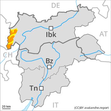
Regions
Western Lechtal Alps, Western Verwall Mountains, Silvretta
Danger level
Danger Level 3 - Considerable above the treeline
Danger Level 2 - Moderate above the treeline
Avalanche Problem
Wind-drifted snow above the treeline, N-NE-E-SE-S-SW-W-NW
New snow, N-NE-E-SE-S-SW-W-NW
As a consequence of fresh snow and wind a sometimes critical avalanche situation will be encountered in some regions.
Wind slabs: As a consequence of fresh snow and a strong northwesterly wind, avalanche prone wind slabs will form above the tree line, in particular in gullies and bowls, and behind abrupt changes in the terrain at high altitudes and in high Alpine regions in all aspects. Even single winter sport participants can release avalanches easily, including large ones. A few natural avalanches are to be expected.
Snowpack
dp 6: cold, loose snow and wind
Over a wide area 20 to 30 cm of snow. will fall. The sometimes strong wind will transport the fresh snow. The snowpack will be subject to considerable local variations.
Tendency
Slight decrease in avalanche danger as a consequence of the ceasing of precipitation.
Regions
Weißkugel Range, Eastern Verwall Mountains, Allgäu Alps, Samnaun Mountains, Eastern Lechtal Alps - Ammergau Alps, Northern Oetz and Stubai Alps, Mieming Mountains, Western Tuxer Alps, Karwendel Mountains, Eastern Tuxer Alps, Brandenberg Alps, Western Kitzbühel Alps, Wilder Kaiser Mountains - Waidring Alps, Eastern Kitzbühel Alps, Central Lechtal Alps, Glockturm Range, Grieskogel Mountains
Danger level
Danger Level 2 - Moderate above the treeline
Danger Level 1 - Low above the treeline
Avalanche Problem
Wind-drifted snow above the treeline, N-NE-E-SE-NW
Fresh wind slabs represent the main danger.
As a consequence of fresh snow and a moderate to strong northwesterly wind, avalanche prone wind slabs will form above the tree line. They can be released even by a single winter sport participant. The avalanche prone locations are to be found in particular adjacent to ridgelines and in gullies and bowls in northwest to north to east facing aspects. At elevated altitudes the avalanche prone locations are more prevalent. In the regions neighbouring those that are subject to danger level 3 (considerable) and in the regions exposed to heavier precipitation the avalanche danger is higher.
Snowpack
dp 6: cold, loose snow and wind
The snowpack will be subject to considerable local variations. The wind slabs of the last few days have bonded well with the old snowpack in all aspects. Over a wide area 10 to 20 cm of snow, and even more in some localities, will fall. The sometimes strong wind will transport the fresh snow. As the day progresses brittle wind slabs will form especially in the regions exposed to heavier precipitation.
Tendency
Gradual decrease in avalanche danger as the snowfall eases.