Regions
Sexten Dolomites, Eastern Pfunderer Mountains, Durreck Range, Val Müstair Alps, Western Rieserferner Mountains, Langtaufers, Western Deferegger Alps, Schnals Ridge, Ortler Range, Southern Stubai Alps, Ulten Valley, Southern Zillertal Alps and High Tauern, Eastern Nonsberger Alps, Saldurn-Mastaun Ridge, Northern Dolomites of Fiemme, Texel Mountains, Gröden Dolomites, Sarntal Alps, Prags Dolomites, Western Pfunderer Mountains
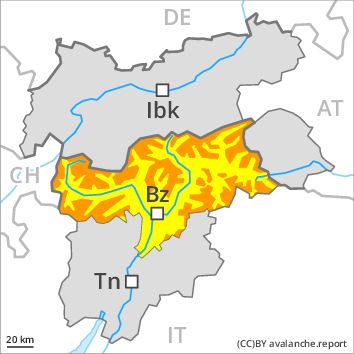
Danger level
Avalanche Problem
Wind-drifted snow above 2200m, N-NE-E-NW
![]()
Slight increase in danger as a consequence of the snowfall.
As a consequence of fresh snow and a strong southwesterly wind, further wind slabs will form as the day progresses, in particular in gullies and bowls, and behind abrupt changes in the terrain at high altitudes and in high Alpine regions in all aspects. Single winter sport participants can release avalanches in some places. The avalanche prone locations are barely recognisable because of the poor visibility.
Avalanches can in isolated cases be released in the old snowpack. Weak layers in the old snowpack can be released in isolated cases in particular at transitions from a shallow to a deep snowpack. Whumpfing sounds and the formation of shooting cracks when stepping on the snowpack indicate the danger.
Snowpack
dp 6: cold, loose snow and wind
Over a wide area 5 to 10 cm of snow. will fall. The strong wind will transport the fresh and old snow. In some cases the various wind slabs have bonded still only poorly with each other and the old snowpack. The snowpack will be subject to considerable local variations. Large-grained weak layers exist in the old snowpack in particular on steep shady slopes.
Tendency
As the snowfall becomes more intense the prevalence and size of the avalanche prone locations will increase during the course of the night. Friday: Slight increase in danger of moist avalanches as a consequence of solar radiation.