Regions
Sexten Dolomites, Latemar, Val Müstair Alps, Langtaufers, Schnals Ridge, Southern Stubai Alps, Southern Zillertal Alps and High Tauern, Saldurn-Mastaun Ridge, Texel Mountains, Sarntal Alps, Western Pfunderer Mountains, Maddalene, Eastern Pfunderer Mountains, Durreck Range, Western Rieserferner Mountains, Western Deferegger Alps, Ortler Range, Ulten Valley, Eastern Nonsberger Alps, Northern Dolomites of Fiemme, Gröden Dolomites, Prags Dolomites, Cembra Valley, Western Nonsberg Alps, Fassa Valley, Sole, Pejo and Rabbi
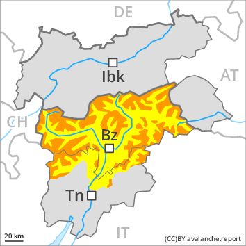
Danger level
Danger Level 3 - Considerable above the treeline
Danger Level 2 - Moderate above the treeline
Avalanche Problem
Wind-drifted snow above the treeline, N-NE-E-SE-S-SW-W-NW
Wet snow above the treeline, SE-S-SW-W

Wind slabs require caution. The danger of moist avalanches will increase a little during the day.
As a consequence of fresh snow and strong wind the wind slabs will increase in size additionally. Fresh and older wind slabs are in some cases prone to triggering in all aspects above the tree line. The avalanche prone locations are to be found in particular adjacent to ridgelines and in gullies and bowls and on wind-loaded slopes. Single winter sport participants can release avalanches in some places, including medium-sized ones.
As a consequence of warming during the day and the solar radiation, the likelihood of dry and moist avalanches being released will increase in particular on very steep sunny slopes at low and intermediate altitudes.
Avalanches can in very isolated cases be released in the old snowpack, in particular at transitions from a shallow to a deep snowpack. Whumpfing sounds and the formation of shooting cracks when stepping on the snowpack indicate the danger.
Snowpack
dp 6: cold, loose snow and wind
10 to 15 cm of snow, and even more in some localities, will fall until the early morning. The strong wind will transport the fresh and old snow significantly. In some cases the various wind slabs have bonded still only poorly with each other and the old snowpack. The snowpack will be subject to considerable local variations. Large-grained weak layers exist in the old snowpack in particular on steep shady slopes.
Tendency
As a consequence of northerly wind, further wind slabs will form.
Regions
Southern Adamello, Primiero - Pale di S. Martino, Adamello - Presanella, Prealps, Northern Brenta - Peller, Bondone and Stivo, Vallarsa, Folgaria - Laverone, Southern Brenta, Southern Lagorai, Ledro Valley, Northern Lagorai, Paganella, Marzola - Valsugana, Pine' - Mocheni Valley
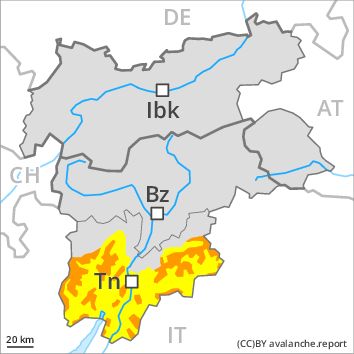
Danger level
Danger Level 3 - Considerable above the treeline
Danger Level 2 - Moderate above the treeline
Avalanche Problem
Wind-drifted snow above the treeline, N-NE-E-SE-S-SW-W-NW
Wet snow above the treeline, SE-S-SW-W
Wind slabs require caution. The danger of moist avalanches will increase a little during the day.
As a consequence of fresh snow and strong wind the wind slabs will increase in size additionally. Fresh and older wind slabs are in some cases prone to triggering in all aspects above the tree line. The avalanche prone locations are to be found in particular adjacent to ridgelines and in gullies and bowls and on wind-loaded slopes. Single winter sport participants can release avalanches in some places, including medium-sized ones.
As a consequence of warming during the day and the solar radiation, the likelihood of dry and moist avalanches being released will increase in particular on very steep sunny slopes at low and intermediate altitudes.
Avalanches can in very isolated cases be released in the old snowpack, in particular at transitions from a shallow to a deep snowpack. Whumpfing sounds and the formation of shooting cracks when stepping on the snowpack indicate the danger.
Snowpack
dp 6: cold, loose snow and wind
10 to 30 cm of snow, but less in some localities, will fall until the early morning above approximately 1000 m. The strong wind will transport the fresh and old snow significantly. In some cases the various wind slabs have bonded still only poorly with each other and the old snowpack. The snowpack will be subject to considerable local variations. Large-grained weak layers exist in the old snowpack in particular on steep shady slopes.
Tendency
As a consequence of northerly wind, further wind slabs will form.
Regions
Western Lechtal Alps, Western Verwall Mountains, Gurgler Range, Central Stubai Alps, Northern Zillertal Alps, Silvretta, Venediger Range
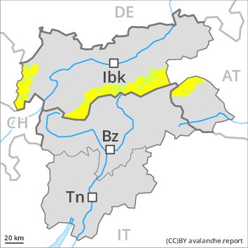
Danger level
Danger Level 2 - Moderate above 2200m
Danger Level 1 - Low above 2200m
Avalanche Problem
Wind-drifted snow above 2200m, N-NE-E-NW
Wind slabs at high altitude.
As a consequence of fresh snow and a sometimes strong wind from westerly directions, mostly small wind slabs will form as the day progresses. The somewhat older wind slabs of the last few days remain in some cases prone to triggering in particular on very steep shady slopes above approximately 2200 m. The fresh and somewhat older wind slabs can be released by a single winter sport participant in some cases. The avalanche prone locations are to be found in particular adjacent to ridgelines and in gullies and bowls in northwest to north to east facing aspects. At elevated altitudes the avalanche prone locations are more prevalent. In the regions neighbouring those that are subject to danger level 3 (considerable) and in the regions exposed to heavier precipitation the avalanche danger is higher.
Snowpack
dp 6: cold, loose snow and wind
The wind slabs of the last few days have settled a little. 10 to 15 cm of snow. will fall until the early morning above approximately 1000 m. The westerly wind will transport the snow. The snowpack will be subject to considerable local variations.
Outgoing longwave radiation during the night will be severely restricted over a wide area.
Tendency
The avalanche danger will persist.
Regions
Weißkugel Range, Eastern Verwall Mountains, Allgäu Alps, Samnaun Mountains, Eastern Lechtal Alps - Ammergau Alps, Northern Oetz and Stubai Alps, Mieming Mountains, Eastern Rieserferner Mountains, Western Tuxer Alps, Karwendel Mountains, Glockner Range, Eastern Deferegger Alps, Eastern Tuxer Alps, Brandenberg Alps, Western Kitzbühel Alps, Wilder Kaiser Mountains - Waidring Alps, Schober Mountains, Lienzer Dolomites, Eastern Kitzbühel Alps, Central Lechtal Alps, Glockturm Range, Grieskogel Mountains
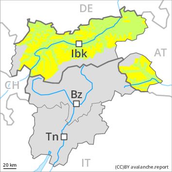
Danger level
Danger Level 2 - Moderate above 2200m
Danger Level 1 - Low above 2200m
Avalanche Problem
Wind-drifted snow above 2200m, N-NE-NW
Wind slabs at high altitude.
As a consequence of a sometimes strong wind from westerly directions, mostly small wind slabs will form as the day progresses. The somewhat older wind slabs of the last few days remain in some cases prone to triggering in particular on very steep shady slopes above approximately 2200 m. The fresh and somewhat older wind slabs can be released by a single winter sport participant in some cases. The avalanche prone locations are to be found in particular adjacent to ridgelines and in gullies and bowls in northwest to north to northeast facing aspects. At elevated altitudes the avalanche prone locations are more prevalent.
Snowpack
dp 6: cold, loose snow and wind
The wind slabs of the last few days have settled a little. The sometimes strong wind will transport the snow. The snowpack will be subject to considerable local variations.
Outgoing longwave radiation during the night will be severely restricted over a wide area.
Tendency
The avalanche danger will persist.