Regions
Durreck Range, Val Müstair Alps, Weißkugel Range, Langtaufers, Western Verwall Mountains, Gurgler Range, Schnals Ridge, Ortler Range, Central Stubai Alps, Eastern Verwall Mountains, Southern Stubai Alps, Northern Zillertal Alps, Allgäu Alps, Silvretta, Southern Zillertal Alps and High Tauern, Venediger Range, Samnaun Mountains, Saldurn-Mastaun Ridge, Northern Oetz and Stubai Alps, Texel Mountains, Western Tuxer Alps, Eastern Tuxer Alps, Western Lechtal Alps, Glockturm Range
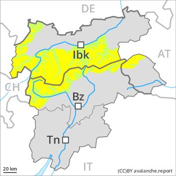
Danger level
Danger Level 2 - Moderate above 2400m
Danger Level 1 - Low above 2400m
Avalanche Problem
Wind-drifted snow above 2400m, N-NE-E-SE-NW

Fresh wind slabs require caution, especially above approximately 2400 m adjacent to ridgelines.
As a consequence of fresh snow and a sometimes strong wind from northerly directions, mostly small wind slabs will form as the day progresses. Caution is to be exercised in particular on very steep slopes above approximately 2400 m adjacent to ridgelines. These avalanche prone locations are rather rare and are clearly recognisable to the trained eye. In the regions exposed to heavier precipitation the avalanche prone locations are more prevalent and larger. Older wind slabs are now only very rarely prone to triggering.
Snowpack
dp 6: cold, loose snow and wind
5 to 10 cm of snow, and up to 20 cm in some localities, will fall. The sometimes strong wind will transport the fresh snow. In some places fresh snow and wind slabs are lying on soft layers, especially on shady slopes above approximately 2400 m. The older wind slabs have bonded well with the old snowpack. The old snowpack will be generally stable. At low altitude hardly any snow is lying.
Tendency
The danger of moist avalanches will increase during the day.
Regions
Sexten Dolomites, Latemar, Southern Adamello, Sarntal Alps, Adamello - Presanella, Western Pfunderer Mountains, Northern Brenta - Peller, Southern Brenta, Southern Lagorai, Northern Lagorai, Maddalene, Pine' - Mocheni Valley, Eastern Pfunderer Mountains, Western Rieserferner Mountains, Western Deferegger Alps, Ulten Valley, Eastern Nonsberger Alps, Northern Dolomites of Fiemme, Eastern Rieserferner Mountains, Gröden Dolomites, Primiero - Pale di S. Martino, Glockner Range, Prags Dolomites, Eastern Deferegger Alps, Schober Mountains, Lienzer Dolomites, Fassa Valley, Sole, Pejo and Rabbi, Marzola - Valsugana
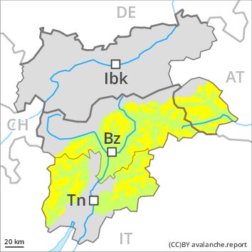
Danger level
Danger Level 2 - Moderate above 2400m
Danger Level 1 - Low above 2400m
Avalanche Problem
Wind-drifted snow above 2400m, N-NE-E-SE-NW
Fresh wind slabs require caution, especially above approximately 2400 m adjacent to ridgelines.
As a consequence of fresh snow and a sometimes strong wind from northerly directions, mostly small wind slabs will form as the day progresses. Caution is to be exercised in particular on very steep slopes above approximately 2400 m adjacent to ridgelines. These avalanche prone locations are rather rare and are clearly recognisable to the trained eye. In the regions exposed to heavier precipitation the avalanche prone locations are more prevalent and larger. Older wind slabs are now only very rarely prone to triggering.
Snowpack
dp 6: cold, loose snow and wind
0 to 10 cm of snow. will fall. The sometimes strong wind will transport the fresh snow. In some places fresh snow and wind slabs are lying on soft layers, especially on shady slopes above approximately 2400 m. The older wind slabs have bonded well with the old snowpack. In very isolated cases weak layers exist in the old snowpack on shady slopes, in particular in areas where the snow cover is rather shallow. At low altitude hardly any snow is lying.
Tendency
The avalanche danger will persist.
Regions
Karwendel Mountains, Brandenberg Alps, Western Kitzbühel Alps, Wilder Kaiser Mountains - Waidring Alps, Eastern Kitzbühel Alps, Central Lechtal Alps, Grieskogel Mountains, Eastern Lechtal Alps - Ammergau Alps, Mieming Mountains
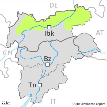
Danger level
Danger Level 1 - Low
Avalanche Problem
Wind-drifted snow above 2400m, N-NE-NW
Fresh wind slabs require caution, especially on very steep shady slopes above approximately 2400 m adjacent to ridgelines.
As a consequence of fresh snow and a sometimes strong wind from northerly directions, small wind slabs will form as the day progresses. Caution is to be exercised in particular on very steep shady slopes above approximately 2400 m adjacent to ridgelines. These avalanche prone locations are rather rare and are clearly recognisable to the trained eye. Avalanches are only small. Older wind slabs are now only very rarely prone to triggering.
Snowpack
dp 6: cold, loose snow and wind
5 to 10 cm of snow. will fall. The sometimes strong wind will transport the fresh snow. The various wind slabs have bonded generally well with each other and the old snowpack. At low altitude hardly any snow is lying.
Tendency
The danger of moist avalanches will increase during the day.