Regions
Texel Mountains, Durreck Range, Western Rieserferner Mountains, Val Müstair Alps, Langtaufers, Ortler Range, Schnals Ridge, Southern Stubai Alps, Southern Zillertal Alps and High Tauern, Saldurn-Mastaun Ridge
AM
Danger level
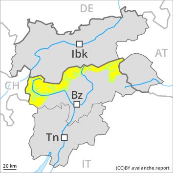
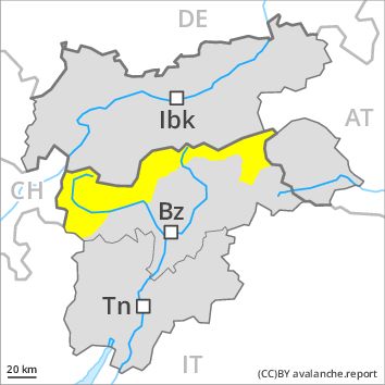
Danger Level 2 - Moderate above the treeline
Danger Level 1 - Low above the treeline
Avalanche Problem
Wind-drifted snow above the treeline, N-NE-E-SE-S-SW-W-NW
PM
Danger level
Danger Level 2 - Moderate above the treeline
Danger Level 2 - Moderate above the treeline
Avalanche Problem
Wind-drifted snow above the treeline, N-NE-E-SE-S-SW-W-NW
Wet snow above the treeline, N-NE-E-SE-S-SW-W-NW
Fresh wind slabs require caution.
As a consequence of fresh snow and a sometimes strong wind from northerly directions, mostly small wind slabs will form as the day progresses. Caution is to be exercised in particular on very steep slopes in particular above the tree line adjacent to ridgelines. In the regions exposed to heavier precipitation the avalanche prone locations are more prevalent and larger.
As the snowfall level rises there will be an increase in the danger of moist and wet avalanches. Small and medium-sized natural wet avalanches are possible as a consequence of the rain.
Snowpack
dp 6: cold, loose snow and wind
5 to 10 cm of snow, and even more in some localities, will fall. The sometimes strong wind will transport the fresh snow. In some places fresh snow and wind slabs are lying on soft layers, especially on shady slopes above approximately 2200 m. The older wind slabs have bonded well with the old snowpack.
Tendency
As a consequence of warming, the likelihood of moist and wet avalanches being released will increase for a while.
Regions
Sexten Dolomites, Eastern Pfunderer Mountains, Western Deferegger Alps, Ulten Valley, Eastern Nonsberger Alps, Eastern Rieserferner Mountains, Northern Dolomites of Fiemme, Glockner Range, Gröden Dolomites, Eastern Deferegger Alps, Prags Dolomites, Sarntal Alps, Schober Mountains, Western Pfunderer Mountains, Lienzer Dolomites
Danger level
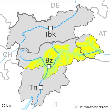
Danger Level 2 - Moderate above 2200m
Danger Level 1 - Low above 2200m
Avalanche Problem
Wind-drifted snow above 2200m, N-NE-E-SE-S-NW

Fresh wind slabs require caution, especially above approximately 2200 m adjacent to ridgelines.
As a consequence of fresh snow and a sometimes strong wind from northerly directions, mostly small wind slabs will form. Caution is to be exercised in particular on very steep slopes above approximately 2200 m adjacent to ridgelines. These avalanche prone locations are rather rare and are clearly recognisable to the trained eye. As the day progresses as a consequence of warming there will be a gradual increase in the danger of moist and wet avalanches.
Snowpack
dp 6: cold, loose snow and wind
In some localities up to 5 cm of snow. will fall. The sometimes strong wind will transport the fresh snow. In some places fresh snow and wind slabs are lying on soft layers, especially on shady slopes above approximately 2200 m. The older wind slabs have bonded well with the old snowpack. In very isolated cases weak layers exist in the old snowpack on shady slopes, in particular in areas where the snow cover is rather shallow.
Tendency
As a consequence of warming, the likelihood of moist and wet avalanches being released will increase for a while.