Regions
Val Müstair Alps, Langtaufers, Ortler Range, Schnals Ridge
AM
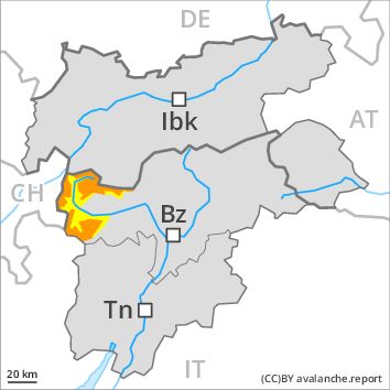
Danger level
Danger Level 3 - Considerable above 2200m
Danger Level 2 - Moderate above 2200m
Avalanche Problem
Wind-drifted snow above 2200m, N-NE-E-SE-S-NW
Wet snow above 2200m, N-NE-E-SE-S-SW-W-NW
PM

Danger level
Danger Level 3 - Considerable above 2200m
Danger Level 2 - Moderate above 2200m
Avalanche Problem
Wet snow above 2200m, N-NE-E-SE-S-SW-W-NW
Wind-drifted snow above 2200m, N-NE-E-SE-S-NW
As a consequence of warming there will be an increase in the danger.
As a consequence of fresh snow and a sometimes strong wind from northerly directions, extensive wind slabs formed. This applies in particular on very steep shady slopes and adjacent to ridgelines as well as at high altitudes and in high Alpine regions. In some cases avalanches are medium-sized and can be released even by a single winter sport participant.
The danger of moist and wet avalanches will already exist in the early morning. As a consequence of warming during the day and the solar radiation, the likelihood of moist and wet avalanches being released will increase appreciably in all aspects. In addition as the day progresses small and medium-sized moist loose snow avalanches are to be expected. Avalanches can in isolated cases be triggered in the old snowpack and reach large size. On rocky sunny slopes the avalanche prone locations are more prevalent.
Snowpack
dp 6: cold, loose snow and wind
dp 3: rain
15 to 25 cm of snow. will fall until the early morning. The sometimes strong wind will transport the fresh snow. In some places fresh snow and wind slabs are lying on soft layers. The fresh and somewhat older wind slabs are in some cases prone to triggering, especially on shady slopes above approximately 2200 m. The older wind slabs have bonded well with the old snowpack.
The surface of the snowpack will cool hardly at all during the overcast night and will already be soft in the early morning.
Tendency
As a consequence of warming during the day and solar radiation there will be an increase in the danger.
Regions
Texel Mountains, Durreck Range, Western Rieserferner Mountains, Southern Stubai Alps, Southern Zillertal Alps and High Tauern, Saldurn-Mastaun Ridge
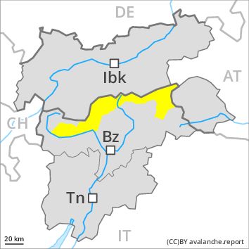
Danger level
Danger Level 2 - Moderate
Avalanche Problem
Wind-drifted snow above 2200m, N-NE-E-SE-NW
Wet snow above 2200m, N-NE-E-SE-S-SW-W-NW

As a consequence of warming there will be an increase in the danger.
As a consequence of fresh snow and a sometimes strong wind from northerly directions, mostly small wind slabs formed. This applies in particular on very steep shady slopes and adjacent to ridgelines at high altitudes and in high Alpine regions. In some cases avalanches are medium-sized and can be released in some cases by a single winter sport participant.
The danger of moist and wet avalanches will already exist in the early morning. As a consequence of warming during the day and the solar radiation, the likelihood of moist and wet avalanches being released will increase appreciably in all aspects. In addition as the day progresses small and medium-sized moist loose snow avalanches are to be expected. Avalanches can in isolated cases be triggered in the old snowpack and reach large size. On rocky sunny slopes the avalanche prone locations are more prevalent.
In places where more snow falls the avalanche danger is greater.
Snowpack
dp 6: cold, loose snow and wind
dp 3: rain
10 to 20 cm of snow, and even more in some localities, will fall until the early morning. The sometimes strong wind will transport the fresh snow. In some places fresh snow and wind slabs are lying on soft layers. The fresh and somewhat older wind slabs are in some cases prone to triggering, especially on shady slopes above approximately 2200 m. The older wind slabs have bonded well with the old snowpack.
The surface of the snowpack will cool hardly at all during the overcast night and will already be soft in the early morning.
Tendency
As a consequence of warming during the day and solar radiation there will be an increase in the danger.
Regions
Gröden Dolomites, Prags Dolomites, Sarntal Alps, Western Pfunderer Mountains, Sexten Dolomites, Eastern Pfunderer Mountains, Western Deferegger Alps, Ulten Valley, Eastern Nonsberger Alps, Northern Dolomites of Fiemme
AM
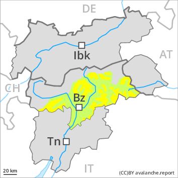
Danger level
Danger Level 2 - Moderate above 2200m
Danger Level 1 - Low above 2200m
Avalanche Problem
Persistent weak layer above 2400m, N-NE-NW
Wet snow above 2200m, N-NE-E-SE-S-SW-W-NW
PM
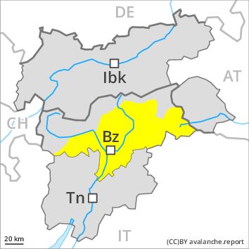
Danger level
Danger Level 2 - Moderate above 2200m
Danger Level 2 - Moderate above 2200m
Avalanche Problem
Wet snow above 2400m, N-NE-E-SE-S-SW-W-NW
Persistent weak layer above 2400m, N-NE-NW
Wet snow requires caution.
The avalanches can be released, in particular by large loads. They can in isolated cases be released in the old snowpack. As a consequence of fresh snow and a sometimes strong wind from northerly directions, mostly small wind slabs formed in the last two days. As the day progresses as a consequence of warming there will be a gradual increase in the danger of moist and wet avalanches. These avalanche prone locations are rather rare and are clearly recognisable to the trained eye.
Snowpack
dp 6: cold, loose snow and wind
Faceted weak layers exist in the snowpack especially on steep, little used shady slopes. The sometimes strong wind has transported the fresh snow and, in some cases, old snow as well. Outgoing longwave radiation during the night will be quite good over a wide area. A clear night will be followed by quite favourable conditions for a short time, but the danger of wet avalanches will increase later.
Tendency
As a consequence of warming during the day and solar radiation there will be an increase in the danger.