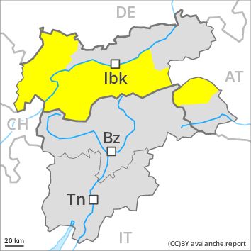
Regions
Latemar, Southern Adamello, Primiero - Pale di S. Martino, Adamello - Presanella, Northern Brenta - Peller, Western Nonsberg Alps, Southern Brenta, Fassa Valley, Sole, Pejo and Rabbi, Southern Lagorai, Northern Lagorai, Maddalene, Paganella, Pine' - Mocheni Valley
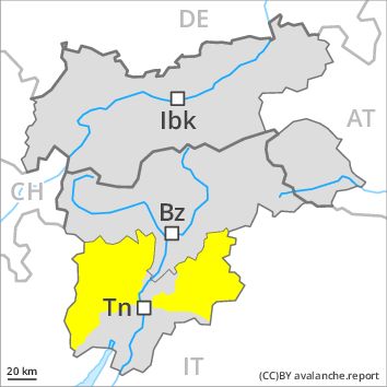
Danger level
Danger Level 2 - Moderate above the treeline
Danger Level 2 - Moderate above the treeline
Avalanche Problem
Wet snow, N-NE-E-SE-S-SW-W-NW
Persistent weak layer above 2200m, N-NE-NW

The danger of moist and wet avalanches will decrease gradually, but only during the night.
The danger of wet and gliding avalanches will decrease gradually. Until the temperature drops more avalanches are possible until late in the night, even medium-sized ones. Weak layers exist in the snowpack in particular on wind-loaded slopes. This applies on steep northeast, north and northwest facing slopes above approximately 2200 m adjacent to ridgelines. These avalanche prone locations are difficult to recognise. They can be released in isolated cases, but mostly only by large additional loads, in high Alpine regions. As a consequence of the rain, the likelihood of moist and wet avalanches being released will increase a little in particular on steep slopes at intermediate altitudes.
Snowpack
dp 10: springtime scenario
The older wind slabs have bonded well with the old snowpack. In very isolated cases weak layers exist in the old snowpack on shady slopes, in particular in areas where the snow cover is rather shallow. In some places wind slabs are lying on soft layers, in particular on shady slopes above approximately 2400 m. At low altitude a little snow is lying.
Tendency
Slight decrease in avalanche danger as the snowfall level drops.
Regions
Eastern Deferegger Alps, Schober Mountains, Lienzer Dolomites
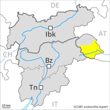
Danger level
Danger Level 2 - Moderate
Avalanche Problem
Gliding snow above 2600m, E-SE-S-SW-W
Wind-drifted snow above 2400m, N-NE-E-NW
Gliding snow represents the main danger. Wind slabs are in isolated cases prone to triggering at high altitudes and in high Alpine regions.
Gradual decrease in danger of wet avalanches as the temperature drops. Not yet all gliding avalanches have been released especially on steep grassy slopes. Caution is to be exercised in areas with glide cracks.
As a consequence of a sometimes strong westerly wind, small wind slabs will form as well. These are in isolated cases prone to triggering, especially on very steep shady slopes above approximately 2400 m adjacent to ridgelines. These avalanche prone locations are very rare and are clearly recognisable to the trained eye. The avalanches are only small.
Snowpack
dp 2: gliding snow
dp 6: cold, loose snow and wind
At low altitude no snow is lying. At intermediate altitudes the snow is wet. Outgoing longwave radiation during the night will be reduced. The somewhat older wind slabs have bonded well with the old snowpack in all aspects. Fresh wind slabs require caution.
Tendency
Further decrease in danger of moist avalanches as the temperature drops.
Regions
Sexten Dolomites, Eastern Pfunderer Mountains, Durreck Range, Western Rieserferner Mountains, Val Müstair Alps, Western Deferegger Alps, Langtaufers, Ortler Range, Schnals Ridge, Southern Stubai Alps, Ulten Valley, Southern Zillertal Alps and High Tauern, Eastern Nonsberger Alps, Northern Dolomites of Fiemme, Saldurn-Mastaun Ridge, Gröden Dolomites, Texel Mountains, Prags Dolomites, Sarntal Alps, Western Pfunderer Mountains
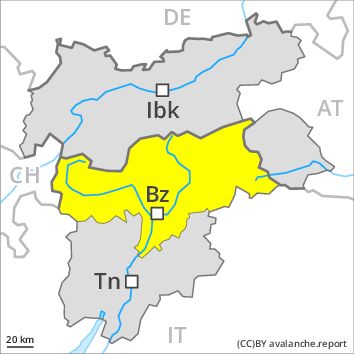
Danger level
Danger Level 2 - Moderate
Avalanche Problem
Wet snow above 2400m, N-NE-E-SE-S-SW-W-NW
Persistent weak layer above 2400m, N-NE-NW
The danger of moist and wet avalanches will increase a little during the day.
The Avalanche Warning Service currently has only a small amount of information about the snowpack, so that the avalanche danger should be investigated especially thoroughly in the relevant locality.
Small and, in isolated cases, medium-sized moist and wet avalanches are possible below approximately 2400 m. The danger of wet and gliding avalanches will increase a little during the day. Weak layers exist in the snowpack. This applies on steep northeast, north and northwest facing slopes above approximately 2400 m. These avalanche prone locations are difficult to recognise. Weak layers in the old snowpack can be released especially by large additional loads in particular on steep, little used shady slopes.
Snowpack
Outgoing longwave radiation during the night will be severely restricted. The surface of the snowpack will freeze to form a strong crust only at high altitudes and will soften during the day. Faceted weak layers exist in the old snowpack on shady slopes, in particular in areas where the snow cover is rather shallow. The older wind slabs have bonded well with the old snowpack.
Tendency
The danger of moist and wet avalanches will decrease gradually.
Regions
Karwendel Mountains, Brandenberg Alps, Western Kitzbühel Alps, Wilder Kaiser Mountains - Waidring Alps, Eastern Kitzbühel Alps, Mieming Mountains
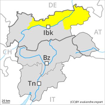
Danger level
Danger Level 2 - Moderate
Avalanche Problem
Gliding snow above 2600m, E-SE-S-SW-W
Wind-drifted snow above 2400m, N-NE-E-NW
Gliding snow represents the main danger. Wind slabs are in isolated cases prone to triggering at high altitudes and in high Alpine regions.
As a consequence of the rain, the likelihood of wet avalanches being released will increase for a while in all aspects below approximately 2200 m. Gliding avalanches and wet loose snow avalanches require caution. Gradual decrease in danger of wet avalanches as the snowfall level drops. Not yet all gliding avalanches have been released especially on steep grassy slopes. Caution is to be exercised in areas with glide cracks.
As a consequence of fresh snow and a sometimes strong westerly wind, mostly small wind slabs will form as well. These are in isolated cases prone to triggering, especially above approximately 2400 m adjacent to ridgelines. These avalanche prone locations are rather rare and are clearly recognisable to the trained eye. The avalanches are only small.
Snowpack
dp 2: gliding snow
dp 6: cold, loose snow and wind
At low altitude no snow is lying. At intermediate altitudes the snow is wet. Outgoing longwave radiation during the night will be barely evident. The somewhat older wind slabs have bonded well with the old snowpack in all aspects. Fresh wind slabs require caution.
Tendency
Further decrease in danger of moist avalanches as the temperature drops.
Regions
Weißkugel Range, Western Verwall Mountains, Gurgler Range, Central Stubai Alps, Eastern Verwall Mountains, Northern Zillertal Alps, Allgäu Alps, Silvretta, Venediger Range, Samnaun Mountains, Eastern Lechtal Alps - Ammergau Alps, Northern Oetz and Stubai Alps, Eastern Rieserferner Mountains, Western Tuxer Alps, Glockner Range, Eastern Tuxer Alps, Western Lechtal Alps, Central Lechtal Alps, Glockturm Range, Grieskogel Mountains
Danger level
Danger Level 2 - Moderate
Avalanche Problem
Gliding snow above 2600m, E-SE-S-SW-W
Wind-drifted snow above 2400m, N-NE-E-NW
Gliding snow represents the main danger. Wind slabs are in isolated cases prone to triggering at high altitudes and in high Alpine regions.
As a consequence of the rain, the likelihood of wet avalanches being released will increase for a while in all aspects below approximately 2200 m. Gliding avalanches and wet loose snow avalanches require caution. Gradual decrease in danger of wet avalanches as the snowfall level drops. Not yet all gliding avalanches have been released especially on steep grassy slopes. Caution is to be exercised in areas with glide cracks.
As a consequence of fresh snow and a sometimes strong westerly wind, mostly small wind slabs will form as well. These are in isolated cases prone to triggering, especially above approximately 2400 m adjacent to ridgelines. These avalanche prone locations are rather rare and are clearly recognisable to the trained eye. The avalanches are only small.
In addition the no longer entirely fresh wind slabs should be taken into account, in particular on extremely steep shady slopes above approximately 2800 m.
Snowpack
dp 2: gliding snow
dp 6: cold, loose snow and wind
At low altitude no snow is lying. At intermediate altitudes the snow is wet. Outgoing longwave radiation during the night will be barely evident. The more recent wind slabs have bonded well with the old snowpack in all aspects below approximately 2800 m. In some places fresh snow and wind slabs are lying on soft layers. This applies in particular above approximately 2800 m on shady slopes. In very isolated cases weak layers exist in the old snowpack in particular on west, north and northeast facing slopes, especially above approximately 2600 m.
Tendency
Further decrease in danger of moist avalanches as the temperature drops.
Regions
Prealps, Cembra Valley, Bondone and Stivo, Vallarsa, Folgaria - Laverone, Ledro Valley, Marzola - Valsugana
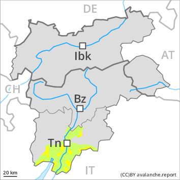
Danger level
Danger Level 2 - Moderate above the treeline
Danger Level 1 - Low above the treeline
Avalanche Problem
Gliding snow, N-NE-E-SE-S-SW-W-NW
Wet snow, N-NE-E-SE-S-SW-W-NW
Moist and wet avalanches require caution. As a consequence of rain an unfavourable avalanche situation will still be encountered.
The surface of the snowpack will freeze to form a strong crust only at high altitudes and will soften quickly. The danger of wet and gliding avalanches will decrease gradually, but only during the night. As a consequence of the rain, the likelihood of moist and wet avalanches being released will increase quickly in particular on rocky slopes at low and intermediate altitudes. In particular on steep sunny slopes and on wind-loaded slopes small to medium-sized moist avalanches are possible until the temperature drops.
Snowpack
dp 2: gliding snow
In some places fresh snow and wind slabs are lying on old snow containing large grains. This applies in particular on shady slopes at high altitudes and in high Alpine regions. The old snowpack will be subject to considerable local variations at low and intermediate altitudes. At low altitude no snow is lying on south facing slopes.
Tendency
Slight decrease in avalanche danger as the snowfall level drops.