Regions
Val Müstair Alps, Western Verwall Mountains, Langtaufers, Eastern Verwall Mountains, Schnals Ridge, Silvretta, Southern Stubai Alps, Samnaun Mountains, Southern Zillertal Alps and High Tauern, Northern Oetz and Stubai Alps, Western Tuxer Alps, Texel Mountains, Eastern Tuxer Alps, Western Pfunderer Mountains, Glockturm Range, Eastern Pfunderer Mountains, Durreck Range, Weißkugel Range, Western Rieserferner Mountains, Gurgler Range, Central Stubai Alps, Ortler Range, Northern Zillertal Alps, Allgäu Alps, Venediger Range, Eastern Lechtal Alps - Ammergau Alps, Eastern Rieserferner Mountains, Glockner Range, Western Lechtal Alps, Central Lechtal Alps, Grieskogel Mountains
Danger level
Avalanche Problem
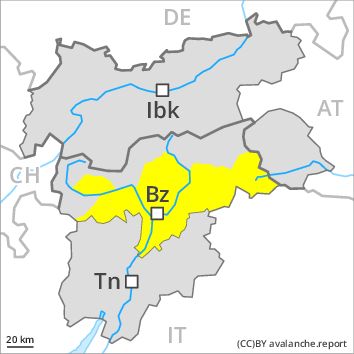
Wind-drifted snow above the treeline, N-NE-E-W-NW
![]()
Wind slabs are in some cases prone to triggering above the tree line.
As a consequence of fresh snow and a sometimes strong westerly wind, mostly small wind slabs will form in particular above the tree line. These are in some cases prone to triggering, especially adjacent to ridgelines and in gullies and bowls. These avalanche prone locations are rather rare and are clearly recognisable to the trained eye. Mostly the avalanches are rather small but in some cases easily released.
In addition the no longer entirely fresh wind slabs should be taken into account, in particular on extremely steep shady slopes above approximately 2800 m.
Snowpack
dp 6: cold, loose snow and wind
At low altitude no snow is lying. At intermediate altitudes the snow is wet. Outgoing longwave radiation during the night will be barely evident. The fresh and somewhat older wind slabs have bonded well with the old snowpack in all aspects below approximately 2000 m. In some places fresh snow and wind slabs are lying on soft layers. This applies in particular above approximately 2000 m on shady slopes. In very isolated cases weak layers exist in the old snowpack in particular on west, north and northeast facing slopes, especially above approximately 2600 m.
Tendency
Hardly any increase in avalanche danger as a consequence of the snowfall.