Regions
Gröden Dolomites, Prags Dolomites, Sarntal Alps, Sexten Dolomites, Ortler Range, Ulten Valley, Eastern Nonsberger Alps, Northern Dolomites of Fiemme
Danger level
Avalanche Problem
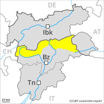
Wind-drifted snow above 2200m, N-NE-E-W-NW
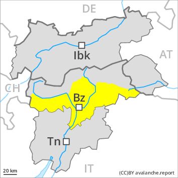
Wet snow above 1800m, N-NE-E-SE-S-SW-W-NW
![]()
Wind slabs are in some cases prone to triggering at high altitudes and in high Alpine regions.
As a consequence of fresh snow and a sometimes moderate southwesterly wind, mostly small wind slabs formed on Saturday. This applies in particular adjacent to ridgelines and in gullies and bowls. These avalanche prone locations are clearly recognisable to the trained eye. The fresh snow must be evaluated with care and prudence in particular on steep shady slopes above approximately 2200 m. Mostly the avalanches are rather small but in some cases easily released.
As a consequence of warming during the day and the solar radiation, the likelihood of moist and wet avalanches being released will increase gradually.
Snowpack
Especially in the Ortler Range, in the Sarntal Alps and in the Dolomites 10 to 20 cm of snow. fell above approximately 1500 m. At low altitude hardly any snow is lying. At intermediate altitudes the snow is wet. In very isolated cases weak layers exist in the old snowpack in particular on west, north and northeast facing slopes. Outgoing longwave radiation during the night will be severely restricted over a wide area. The surface of the snowpack will freeze to form a strong crust only at high altitudes and will soften during the day.
Tendency
Gradual decrease in avalanche danger.