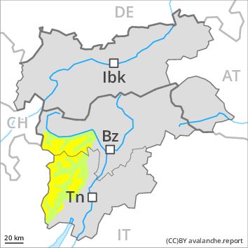
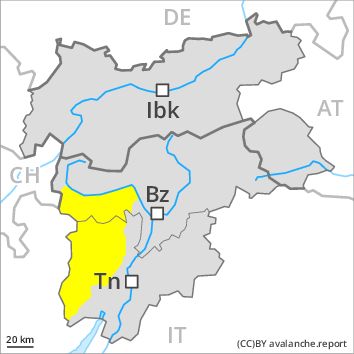
Regions
Southern Adamello, Adamello - Presanella, Northern Brenta - Peller, Southern Brenta, Sole, Pejo and Rabbi, Ortler Range, Maddalene, Ulten Valley
AM
Danger level
Danger Level 2 - Moderate above 2400m
Danger Level 1 - Low above 2400m
Avalanche Problem
Wind-drifted snow above 2400m, N-NE-E-NW
PM
Danger level
Danger Level 2 - Moderate above 2400m
Danger Level 2 - Moderate above 2400m
Avalanche Problem
Wet snow above 2600m, SE-S-SW-W
Wind-drifted snow above 2400m, N-NE-E-NW
Wind slabs require caution. The danger of wet avalanches will increase during the day.
The Avalanche Warning Service currently has only a small amount of information that has been collected in the field, so that the avalanche danger should be investigated especially thoroughly in the relevant locality.
As a consequence of a sometimes moderate southwesterly wind, small wind slabs formed in the last few days. This applies in particular adjacent to ridgelines and in gullies and bowls. Mostly the avalanches are rather small but in some cases easily released.
As a consequence of warming during the day and the solar radiation, the likelihood of moist and wet avalanches being released will increase gradually. Transportation routes situated at higher altitudes and exposed parts of transportation routes are endangered in some cases especially at intermediate and high altitudes.
Snowpack
dp 10: springtime scenario
dp 6: cold, loose snow and wind
Outgoing longwave radiation during the night will be quite good over a wide area. The surface of the snowpack will freeze to form a strong crust and will soften earlier than the day before. At intermediate altitudes the snow is wet. Individual weak layers exist in the old snowpack. At low altitude no snow is lying.
Tendency
Increase in danger of wet avalanches as a consequence of warming during the day and solar radiation.
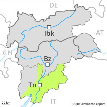
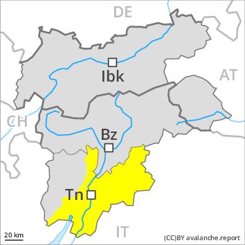
Regions
Latemar, Primiero - Pale di S. Martino, Prealps, Cembra Valley, Bondone and Stivo, Vallarsa, Western Nonsberg Alps, Folgaria - Laverone, Fassa Valley, Southern Lagorai, Ledro Valley, Northern Lagorai, Paganella, Marzola - Valsugana, Pine' - Mocheni Valley
AM
Danger level
Danger Level 1 - Low
Avalanche Problem
Wind-drifted snow above 2400m, N-NE-NW
PM
Danger level
Danger Level 2 - Moderate
Avalanche Problem
Wet snow above 2600m, E-SE-S-SW-W
Wind-drifted snow above 2400m, N-NE-NW
A favourable early-morning avalanche situation will prevail. The danger of wet avalanches will increase during the day.
The Avalanche Warning Service currently has only a small amount of information about the snowpack, so that the avalanche danger should be investigated especially thoroughly in the relevant locality.
As a consequence of a sometimes moderate southwesterly wind, mostly small wind slabs formed in the last few days. The avalanches are small.
As a consequence of warming during the day and the solar radiation, the likelihood of moist and wet avalanches being released will increase gradually. Transportation routes situated at higher altitudes and exposed parts of transportation routes are endangered in some cases especially at intermediate and high altitudes.
Snowpack
Outgoing longwave radiation during the night will be quite good over a wide area. The surface of the snowpack will freeze to form a strong crust and will soften earlier than the day before. At intermediate altitudes the snow is wet. Individual weak layers exist in the old snowpack. At low altitude no snow is lying.
Tendency
Increase in danger of wet avalanches as a consequence of warming during the day and solar radiation.