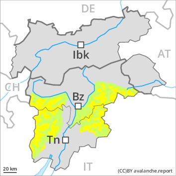
Regions
Sexten Dolomites, Latemar, Ortler Range, Ulten Valley, Northern Dolomites of Fiemme, Gröden Dolomites, Southern Adamello, Primiero - Pale di S. Martino, Prags Dolomites, Adamello - Presanella, Northern Brenta - Peller, Southern Brenta, Fassa Valley, Sole, Pejo and Rabbi, Northern Lagorai, Maddalene
Danger level
Danger Level 2 - Moderate above the treeline
Danger Level 1 - Low above the treeline
Avalanche Problem
Wind-drifted snow above the treeline, N-NE-E-SE-S-SW-W-NW

Fresh wind slabs above the tree line.
The Avalanche Warning Service currently has only a small amount of information that has been collected in the field.
The wind slabs represent the main danger. These can in some cases be released by small loads and reach medium size, especially adjacent to ridgelines and in pass areas in all aspects in particular above the tree line.
As a consequence of the solar radiation, the likelihood of loose snow avalanches being released will increase a little on steep sunny slopes. Exposed parts of transportation routes can be endangered very occasionally in these regions.
Snowpack
dp 6: cold, loose snow and wind
Over a wide area 20 to 40 cm of snow, and even more in some localities, fell. Over a wide area fresh snow and wind slabs are lying on a hard crust. The fresh wind slabs are lying on weak layers in particular on shady slopes above the tree line. The weather will be cold. The brittle wind slabs are bonding only slowly with the old snowpack in particular on shady slopes.
Tendency
Slight increase in danger of moist avalanches as a consequence of solar radiation.
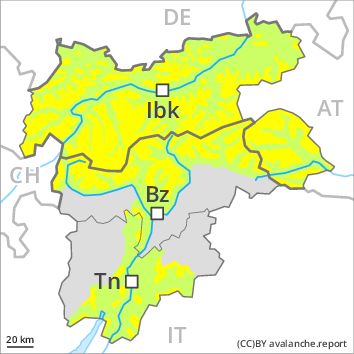
Regions
Bondone and Stivo, Folgaria - Laverone, Southern Lagorai, Allgäu Alps, Eastern Lechtal Alps - Ammergau Alps, Mieming Mountains, Karwendel Mountains, Brandenberg Alps, Wilder Kaiser Mountains - Waidring Alps, Western Lechtal Alps, Central Lechtal Alps, Grieskogel Mountains, Val Müstair Alps, Western Verwall Mountains, Langtaufers, Eastern Verwall Mountains, Schnals Ridge, Silvretta, Southern Stubai Alps, Samnaun Mountains, Southern Zillertal Alps and High Tauern, Northern Oetz and Stubai Alps, Saldurn-Mastaun Ridge, Western Tuxer Alps, Texel Mountains, Eastern Tuxer Alps, Sarntal Alps, Western Kitzbühel Alps, Western Pfunderer Mountains, Eastern Kitzbühel Alps, Glockturm Range, Pine' - Mocheni Valley, Eastern Pfunderer Mountains, Durreck Range, Weißkugel Range, Western Rieserferner Mountains, Gurgler Range, Western Deferegger Alps, Central Stubai Alps, Northern Zillertal Alps, Venediger Range, Eastern Nonsberger Alps, Eastern Rieserferner Mountains, Glockner Range, Eastern Deferegger Alps, Prealps, Schober Mountains, Cembra Valley, Lienzer Dolomites, Vallarsa, Western Nonsberg Alps, Ledro Valley, Paganella, Marzola - Valsugana
Danger level
Danger Level 2 - Moderate above the treeline
Danger Level 1 - Low above the treeline
Avalanche Problem
Wind-drifted snow above the treeline, N-NE-NW
Moderate avalanche danger will be encountered over a wide area.
The Avalanche Warning Service currently has only a small amount of information that has been collected in the field.
The wind slabs represent the main danger. These can in some cases be released by small loads and reach medium size. This applies in particular on wind-loaded slopes as well as on steep shady slopes above the tree line.
As a consequence of the solar radiation, the likelihood of loose snow avalanches being released will increase a little in particular on rocky slopes.
Snowpack
dp 6: cold, loose snow and wind
Over a wide area 10 to 20 cm of snow, and even more in some localities, fell. Over a wide area fresh snow and wind slabs are lying on a hard crust. This applies in particular on east, south and west facing slopes. The wind slabs of Monday are lying on weak layers in particular on shady slopes above the tree line. The weather will be cold. The brittle wind slabs remain in some cases prone to triggering in particular on steep shady slopes above the tree line.
Tendency
Gradual increase in danger of dry and moist avalanches as a consequence of warming during the day and solar radiation.