Regions
Val Müstair Alps, Western Verwall Mountains, Langtaufers, Eastern Verwall Mountains, Schnals Ridge, Silvretta, Southern Stubai Alps, Samnaun Mountains, Southern Zillertal Alps and High Tauern, Northern Oetz and Stubai Alps, Saldurn-Mastaun Ridge, Western Tuxer Alps, Texel Mountains, Eastern Tuxer Alps, Western Kitzbühel Alps, Eastern Kitzbühel Alps, Glockturm Range, Durreck Range, Weißkugel Range, Gurgler Range, Central Stubai Alps, Northern Zillertal Alps, Allgäu Alps, Venediger Range, Eastern Lechtal Alps - Ammergau Alps, Mieming Mountains, Karwendel Mountains, Brandenberg Alps, Wilder Kaiser Mountains - Waidring Alps, Western Lechtal Alps, Central Lechtal Alps, Grieskogel Mountains
Danger level
Avalanche Problem
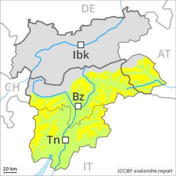
Wind-drifted snow above 2400m, N-NE-NW
Wet snow above 2400m, N-NE-E-SE-S-SW-W-NW
![]()
The surface of the snowpack will only just freeze.
The Avalanche Warning Service currently has only a small amount of information that has been collected in the field.
The older wind slabs can in some cases be released by small loads and reach medium size. This applies in particular on steep shady slopes as well as adjacent to ridgelines and in pass areas above the tree line.
Already in the early morning moist and wet avalanches are possible below approximately 2200 m. As a consequence of the solar radiation, the likelihood of moist and wet avalanches being released will increase gradually. In the regions where the outgoing longwave radiation during the night is reduced the danger will increase more quickly.
Snowpack
dp 6: cold, loose snow and wind
dp 10: springtime scenario
The wind slabs of Monday are lying on weak layers in particular on shady slopes above the tree line. The brittle wind slabs remain in some cases prone to triggering in particular on steep shady slopes above the tree line.
Outgoing longwave radiation during the night will be reduced over a wide area. The surface of the snowpack will cool hardly at all during the overcast night and will soften earlier than the day before.
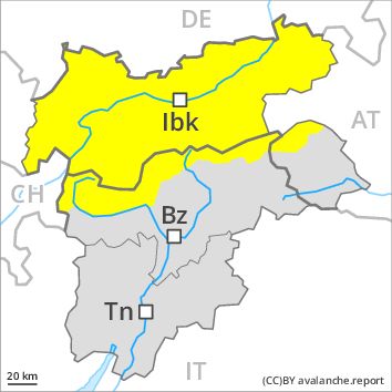
Tendency
Slight increase in danger of dry and moist avalanches as a consequence of warming during the day and solar radiation.