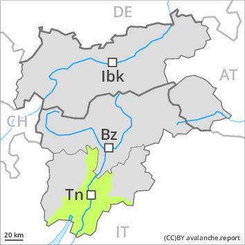
Regions
Prealps, Cembra Valley, Bondone and Stivo, Vallarsa, Western Nonsberg Alps, Folgaria - Laverone, Ledro Valley, Paganella, Marzola - Valsugana, Pine' - Mocheni Valley
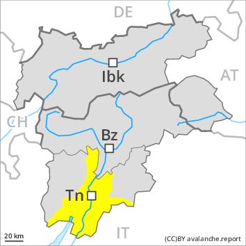
AM
Danger level
Danger Level 1 - Low
Avalanche Problem
Favourable situation above 2400m
PM
Danger level
Danger Level 2 - Moderate
Avalanche Problem
Wet snow above 2000m, N-NE-E-SE-S-SW-W-NW
Gliding snow above 2000m, E-SE-S-SW-W
Natural wet avalanches in the afternoon.
The Avalanche Warning Service currently has only a small amount of information that has been collected in the field.
As a consequence of warming during the day and the solar radiation, the likelihood of moist and wet avalanches being released will increase gradually. As the day progresses individual small and, in isolated cases, medium-sized moist and wet avalanches are possible above approximately 2000 m. This also applies in isolated cases on very steep shady slopes and adjacent to ridgelines and in pass areas.
From origins in starting zones where no previous releases have taken place moist and wet avalanches are possible, even large ones in isolated cases.
Snowpack
dp 10: springtime scenario
dp 2: gliding snow
Outgoing longwave radiation during the night will be severely restricted. The surface of the snowpack will freeze to form a strong crust only at high altitudes and will soften during the day. Isolated avalanche prone weak layers exist in the old snowpack especially on very steep shady slopes. At low and intermediate altitudes only a little snow is lying.
Tendency
The weather will be mild. Increase in danger of wet and gliding avalanches as a consequence of warming during the day and solar radiation.
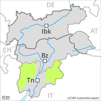
Regions
Southern Adamello, Primiero - Pale di S. Martino, Adamello - Presanella, Northern Brenta - Peller, Southern Brenta, Fassa Valley, Sole, Pejo and Rabbi, Southern Lagorai, Northern Lagorai, Latemar, Maddalene
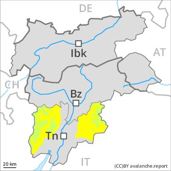
AM
Danger level
Danger Level 1 - Low above 2800m
Danger Level 1 - Low above 2800m
Avalanche Problem
Favourable situation above 2400m
PM
Danger level
Danger Level 1 - Low above 2800m
Danger Level 2 - Moderate above 2800m
Avalanche Problem
Wet snow above 2800m above 1800m, N-NE-E-SE-S-SW-W-NW
Gliding snow above 2800m above 1800m, E-SE-S-SW-W
Natural wet avalanches in the afternoon.
The Avalanche Warning Service currently has only a small amount of information that has been collected in the field.
As a consequence of warming during the day and the solar radiation, the likelihood of moist and wet avalanches being released will increase gradually. As the moisture increases small and, in isolated cases, medium-sized moist and wet avalanches are possible below approximately 2800 m. This also applies in isolated cases on very steep shady slopes as well as adjacent to ridgelines and in pass areas at high altitudes and in high Alpine regions.
From origins in starting zones at higher altitudes individual moist and wet avalanches are possible, even quite large ones. Transportation routes situated at higher altitudes in particular can be endangered occasionally here.
Snowpack
dp 10: springtime scenario
dp 2: gliding snow
Outgoing longwave radiation during the night will be quite good. The surface of the snowpack will freeze to form a strong crust only at high altitudes and will soften during the day.
Isolated avalanche prone weak layers exist in the old snowpack especially on very steep shady slopes.
On south and southwest facing slopes thus far only a little snow is lying below approximately 2000 m. At low altitude no snow is lying.
Tendency
The weather will be mild. Increase in danger of wet and gliding avalanches as a consequence of warming during the day and solar radiation.