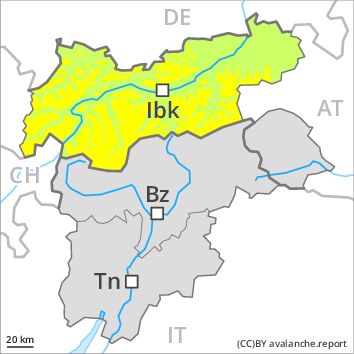
Regions
Weißkugel Range, Western Verwall Mountains, Gurgler Range, Central Stubai Alps, Eastern Verwall Mountains, Northern Zillertal Alps, Allgäu Alps, Silvretta, Samnaun Mountains, Eastern Lechtal Alps - Ammergau Alps, Northern Oetz and Stubai Alps, Mieming Mountains, Western Tuxer Alps, Karwendel Mountains, Eastern Tuxer Alps, Brandenberg Alps, Western Kitzbühel Alps, Wilder Kaiser Mountains - Waidring Alps, Eastern Kitzbühel Alps, Western Lechtal Alps, Central Lechtal Alps, Glockturm Range, Grieskogel Mountains
Danger level
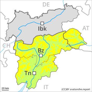
Danger Level 2 - Moderate above 2400m
Danger Level 1 - Low above 2400m
Avalanche Problem
Wet snow above 2400m, N-NE-NW

The avalanche danger will already increase in the early morning, after an overcast night especially in all regions.
The Avalanche Warning Service currently has only a small amount of information that has been collected in the field. Wet avalanches are possible already in the early morning. Especially in places where the night was overcast danger level 2 (moderate) may be reached earlier. In localities where rain falls the avalanche danger is greater. As a consequence of the rain, the likelihood of wet avalanches being released will increase a little. The avalanche prone locations are to be found in particular on steep northwest to north to northeast facing slopes above approximately 2400 m. In some places wet avalanches can release the saturated snowpack and can reach as far as areas without any snow cover. In the runout zone hardly any snow is lying.
Snowpack
dp 10: springtime scenario
Outgoing longwave radiation during the night will be severely restricted in some case. The surface of the snowpack will cool hardly at all during the overcast night and will soften quickly. The weather will be cloudy over a wide area. Individual weak layers exist deep in the old snowpack on steep shady slopes, especially on steep northwest and north facing slopes above approximately 2800 m in areas where the snow cover is rather shallow. At low altitude no snow is lying.
Tendency
Hardly any increase in danger.
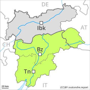
Regions
Sexten Dolomites, Latemar, Val Müstair Alps, Langtaufers, Schnals Ridge, Southern Stubai Alps, Southern Zillertal Alps and High Tauern, Saldurn-Mastaun Ridge, Texel Mountains, Southern Adamello, Sarntal Alps, Adamello - Presanella, Western Pfunderer Mountains, Northern Brenta - Peller, Bondone and Stivo, Folgaria - Laverone, Southern Brenta, Southern Lagorai, Northern Lagorai, Maddalene, Pine' - Mocheni Valley, Eastern Pfunderer Mountains, Durreck Range, Western Rieserferner Mountains, Western Deferegger Alps, Ortler Range, Ulten Valley, Venediger Range, Eastern Nonsberger Alps, Eastern Rieserferner Mountains, Northern Dolomites of Fiemme, Glockner Range, Gröden Dolomites, Primiero - Pale di S. Martino, Eastern Deferegger Alps, Prags Dolomites, Prealps, Schober Mountains, Cembra Valley, Lienzer Dolomites, Vallarsa, Western Nonsberg Alps, Fassa Valley, Sole, Pejo and Rabbi, Ledro Valley, Paganella, Marzola - Valsugana
AM
Danger level
Danger Level 1 - Low above 2400m
Danger Level 1 - Low above 2400m
PM
Danger level
Danger Level 2 - Moderate above 2400m
Danger Level 1 - Low above 2400m
Avalanche Problem
Wet snow above 2400m, N-NE-E-W-NW
The avalanche danger will increase quickly during the day.
The Avalanche Warning Service currently has only a small amount of information that has been collected in the field. Wet avalanches during the day are the main danger. As a consequence of warming during the day and the solar radiation, the likelihood of wet avalanches being released will increase gradually in all regions above approximately 2400 m. In localities where the night was overcast the danger will increase more quickly. The avalanche prone locations are to be found in particular on steep west to north to east facing slopes above approximately 2400 m. In some places wet avalanches can release the saturated snowpack and can reach as far as areas without any snow cover.
Snowpack
dp 10: springtime scenario
Outgoing longwave radiation during the night will be good in some case. The surface of the snowpack will freeze to form a strong crust and will already soften in the late morning. From midday the weather will be partly cloudy over a wide area. In some localities precipitation. The weather will be very mild. Individual weak layers exist deep in the old snowpack on steep shady slopes, especially above approximately 2800 m in areas where the snow cover is rather shallow. At low altitude no snow is lying.
Tendency
Gradual increase in danger of wet avalanches from early morning.