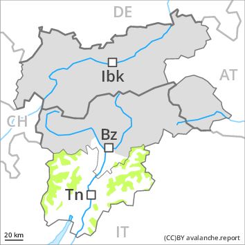
Regions
Latemar, Eastern Nonsberger Alps, Northern Dolomites of Fiemme, Southern Adamello, Primiero - Pale di S. Martino, Adamello - Presanella, Prealps, Northern Brenta - Peller, Cembra Valley, Bondone and Stivo, Vallarsa, Folgaria - Laverone, Western Nonsberg Alps, Southern Brenta, Fassa Valley, Southern Lagorai, Sole, Pejo and Rabbi, Northern Lagorai, Ledro Valley, Maddalene, Paganella, Pine' - Mocheni Valley, Marzola - Valsugana

Danger level
Avalanche Problem
Wet snow above 2400m above 2000m, N-NE-NW
Wind-drifted snow above 2400m, NE-E-SE-S-SW

Slight increase in danger of moist and wet avalanches as a consequence of the rain. This applies below approximately 2400 m.
The Avalanche Warning Service currently has only a small amount of information that has been collected in the field.
Over a wide area light rain below approximately 2400 m. The snowpack remains in most cases moist. Moist and wet avalanches require caution. In some regions some fresh snow above approximately 2200 m. As a consequence of fresh snow and wind individual slab avalanches are possible, but they will be mostly small.
Snowpack
dp 3: rain
dp 6: cold, loose snow and wind
Outgoing longwave radiation during the night will be barely evident. The surface of the snowpack will only just freeze and will already be soft in the early morning. In the event of rain this applies below approximately 2400 m, in particular. In some regions some fresh snow above approximately 2200 m. The fresh snow is bonding quite well with the old snowpack below approximately 2600 m. Individual weak layers exist deep in the old snowpack on steep shady slopes, especially above approximately 2800 m in areas where the snow cover is rather shallow. At low altitude no snow is lying.
Tendency
Slight decrease in danger of moist and wet avalanches as the snowfall level drops. As the snowfall becomes more intense the avalanche prone locations will become more prevalent on Thursday. The fresh snow must be evaluated with care and prudence above approximately 2400 m.