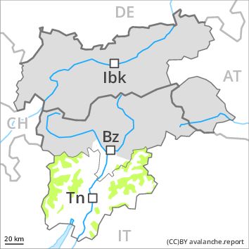
Regions
Sexten Dolomites, Val Müstair Alps, Western Verwall Mountains, Langtaufers, Eastern Verwall Mountains, Schnals Ridge, Silvretta, Southern Stubai Alps, Samnaun Mountains, Southern Zillertal Alps and High Tauern, Northern Oetz and Stubai Alps, Saldurn-Mastaun Ridge, Western Tuxer Alps, Texel Mountains, Eastern Tuxer Alps, Sarntal Alps, Western Kitzbühel Alps, Western Pfunderer Mountains, Eastern Kitzbühel Alps, Glockturm Range, Eastern Pfunderer Mountains, Durreck Range, Weißkugel Range, Western Rieserferner Mountains, Gurgler Range, Western Deferegger Alps, Central Stubai Alps, Ortler Range, Allgäu Alps, Northern Zillertal Alps, Ulten Valley, Eastern Lechtal Alps - Ammergau Alps, Venediger Range, Mieming Mountains, Eastern Rieserferner Mountains, Karwendel Mountains, Glockner Range, Gröden Dolomites, Brandenberg Alps, Eastern Deferegger Alps, Prags Dolomites, Wilder Kaiser Mountains - Waidring Alps, Schober Mountains, Western Lechtal Alps, Lienzer Dolomites, Central Lechtal Alps, Grieskogel Mountains
Danger level
Avalanche Problem
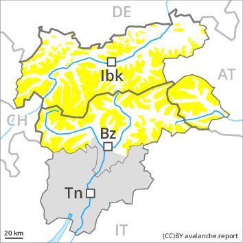
Wind-drifted snow above 2200m, NE-E-SE-S-SW
![]()
The avalanche danger will increase, in the regions exposed to a lot of fresh snow especially.
The Avalanche Warning Service currently has only a small amount of information that has been collected in the field.
During the course of the night as a consequence of the snowfall there will be only a slight increase in the avalanche danger to level 2 (moderate). The wind will be light to moderate over a wide area. Adjacent to ridgelines and in gullies and bowls small wind slabs will form. Avalanches are rather small and can be released in isolated cases by a single winter sport participant. As the day progresses the likelihood of avalanches being released will increase a little. The number and size of avalanche prone locations will increase with altitude.
Snowpack
dp 6: cold, loose snow and wind
In some regions 10 to 20 cm of snow, and even more in some localities, will fall above approximately 2000 m. Individual weak layers exist deep in the old snowpack on steep shady slopes, especially above approximately 2800 m in areas where the snow cover is rather shallow. At low altitude no snow is lying.
Tendency
Slight increase in avalanche danger in particular in the regions exposed to heavier precipitation.