Regions
Sexten Dolomites, Latemar, Southern Lagorai, Northern Lagorai, Allgäu Alps, Eastern Lechtal Alps - Ammergau Alps, Mieming Mountains, Karwendel Mountains, Brandenberg Alps, Wilder Kaiser Mountains - Waidring Alps, Western Lechtal Alps, Central Lechtal Alps, Grieskogel Mountains, Val Müstair Alps, Western Verwall Mountains, Langtaufers, Eastern Verwall Mountains, Schnals Ridge, Silvretta, Southern Stubai Alps, Samnaun Mountains, Southern Zillertal Alps and High Tauern, Northern Oetz and Stubai Alps, Saldurn-Mastaun Ridge, Western Tuxer Alps, Texel Mountains, Eastern Tuxer Alps, Sarntal Alps, Western Kitzbühel Alps, Western Pfunderer Mountains, Eastern Kitzbühel Alps, Glockturm Range, Maddalene, Eastern Pfunderer Mountains, Durreck Range, Weißkugel Range, Western Rieserferner Mountains, Gurgler Range, Western Deferegger Alps, Central Stubai Alps, Ortler Range, Northern Zillertal Alps, Ulten Valley, Venediger Range, Eastern Nonsberger Alps, Eastern Rieserferner Mountains, Northern Dolomites of Fiemme, Glockner Range, Gröden Dolomites, Primiero - Pale di S. Martino, Eastern Deferegger Alps, Prags Dolomites, Schober Mountains, Lienzer Dolomites, Western Nonsberg Alps, Fassa Valley, Sole, Pejo and Rabbi
Danger level
Avalanche Problem
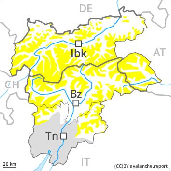
Wet snow above 2000m, N-NE-E-SE-S-SW-W-NW
Wind-drifted snow above 3000m, N-NE-NW
![]()
Regular avalanche bulletins with hazard maps will appear again from around the start of December, depending on the snow situation.
The Avalanche Warning Service currently has only a small amount of information that has been collected in the field. As a consequence of warming during the day and solar radiation more small and, in isolated cases, medium-sized moist and wet avalanches are possible. More frequent moist loose snow avalanches are to be expected. This applies above approximately 2000 m on extremely steep slopes. The prevalence of avalanche prone locations will increase with altitude. Caution is to be exercised in particular in the regions exposed to heavier precipitation.
High Alpine regions: In addition the fresh wind slabs especially adjacent to ridgelines are prone to triggering in some locations. In regions exposed to the foehn wind avalanche prone locations are more prevalent and exist in all aspects.
Snowpack
dp 10: springtime scenario
dp 6: cold, loose snow and wind
Some snow will fall in some regions. The wind will be moderate to strong. In very isolated cases wind slabs are lying on soft layers. This applies in particular on shady slopes above approximately 3000 m. Outgoing longwave radiation during the night will be reduced in some places. The snowpack will become increasingly moist. At low altitude no snow is lying. At intermediate altitudes hardly any snow is lying. The old snowpack will be in most cases stable.
Tendency
As a consequence of warming during the day and solar radiation there will be an increase in the danger of moist and wet avalanches.