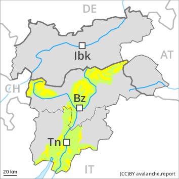
AM
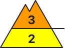
Danger level
 | treeline
|
Avalanche Problem
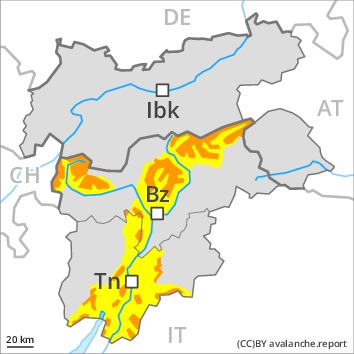
PM
Danger level
Avalanche Problem
Significant increase in avalanche danger as a consequence of new snow and strong wind. With immediate effect, the avalanche bulletin will appear daily at 5 pm.
Early and late morning: Fresh wind slabs represent the main danger. The fresh wind slabs can be released even by a single winter sport participant in particular on steep shady slopes above the tree line. Such avalanche prone locations are clearly recognisable to the trained eye. The avalanches are rather small.
Afternoon: As the snowfall becomes more intense the prevalence of the avalanche prone locations will increase as the day progresses. In all aspects the previously small wind slabs will increase in size appreciably.
Evening and night: An increasing number of medium-sized gliding avalanches are to be expected, in the regions exposed to a lot of new snow especially on steep grassy slopes. In addition an appreciable danger of dry slab avalanches exists. This applies in particular on steep shady slopes above the tree line. Mostly these are medium-sized.
Snowpack
dp.6: cold, loose snow and wind
dp.2: gliding snow
Over a wide area 25 to 50 cm of snow, and even more in some localities, will fall. From early morning the wind will be strong to storm force. In the course of the day the wind slabs will increase in size appreciably.
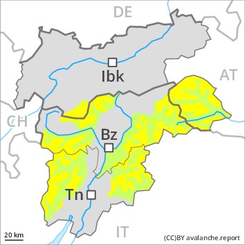
In many cases new snow and wind slabs are lying on soft layers. The old snowpack is weak in some cases and its surface consists of loosely bonded snow lying on a melt-freeze crust that is barely capable of bearing a load, especially on steep shady slopes above the tree line. The meteorological conditions will bring about a substantial weakening of the snowpack during the first half of the night in particular on steep shady slopes.
Tendency
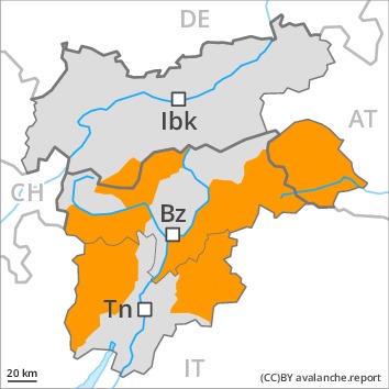
Sharp increase in avalanche danger as a consequence of new snow and stormy weather. A critical avalanche situation will prevail. As the snowfall becomes more intense large and, in isolated cases, very large natural avalanches are to be expected.
AM
Danger level
| treeline
|
Avalanche Problem
 | | Wind-drifted snow |
|  | |  |
 | | Persistent weak layer |
| | |  |
PM
Danger level
 | treeline
|
Avalanche Problem
Significant increase in avalanche danger as a consequence of new snow and strong wind. With immediate effect, the avalanche bulletin will appear daily at 5 pm.
Early and late morning: Fresh wind slabs represent the main danger. The fresh wind slabs can be released by a single winter sport participant on steep shady slopes. The avalanches are rather small.
Afternoon: As the snowfall becomes more intense the prevalence and size of these avalanche prone locations will increase as the day progresses. In all aspects the previously small wind slabs will increase in size appreciably.
An increasing number of medium-sized gliding avalanches are possible, in the regions exposed to a lot of new snow especially on steep grassy slopes as well as. Towards the evening the natural avalanche activity will gradually increase [Emtpy].
Snowpack
dp.6: cold, loose snow and wind
dp.2: gliding snow
Over a wide area 20 to 40 cm of snow, and even more in some localities, will fall. From early morning the wind will be strong to storm force. The new snow and wind slabs will be deposited on soft layers. In the course of the day the wind slabs will increase in size appreciably.
The old snowpack is weak in some cases and its surface consists of loosely bonded snow lying on a melt-freeze crust that is barely capable of bearing a load, especially on steep shady slopes in high Alpine regions.
Tendency
Sharp increase in avalanche danger as a consequence of new snow and stormy weather. A critical avalanche situation will prevail. As the snowfall becomes more intense medium-sized and, in many cases, large natural avalanches are possible.