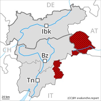
Danger level
Avalanche Problem

Natural avalanches are to be expected.
As a consequence of new snow and wind a very high avalanche danger will prevail. Exposed parts of transportation routes and exposed settlements can be endangered.
A dangerous avalanche situation will prevail. As a consequence of new snow and stormy weather the prevalence and size of the avalanche prone locations will increase as the day progresses. The natural avalanche activity will increase [Emtpy].
From origins in starting zones at higher altitudes natural avalanches are to be expected as the day progresses, even extremely large ones in isolated cases. This applies in all aspects.
On steep grassy slopes more frequent large and, in isolated cases, very large gliding avalanches are to be expected below approximately 2600 m. In some regions increase in danger of gliding avalanches as a consequence of the rain. Naturally triggered avalanches confirm a dangerous avalanche situation.
Snowpack
dp.6: cold, loose snow and wind
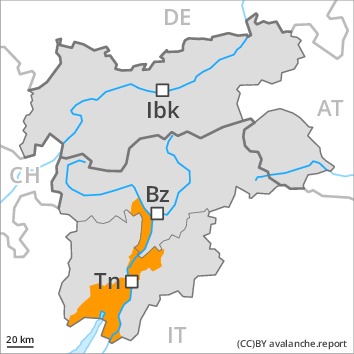
dp.2: gliding snow
In the regions exposed to heavier precipitation 80 to 140 cm of snow fell. Over a wide area 60 to 110 cm of snow, and even more in some localities, will fall on Sunday. Over a wide area strong southerly wind. In the course of the day the wind slabs will increase in size appreciably. In many cases new snow and wind slabs are lying on soft layers. The old snowpack is weak in some cases and its surface consists of loosely bonded snow lying on a melt-freeze crust that is barely capable of bearing a load, especially on steep shady slopes above the tree line.
Tendency
Gradual decrease in avalanche danger as the snowfall eases. Caution is to be exercised in areas with glide cracks.
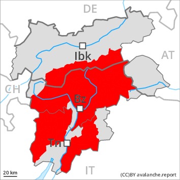
Danger level
Avalanche Problem
Natural avalanches are to be expected.
Avalanches can reach valley bottoms and in the majority of cases endanger exposed transportation routes.
A critical avalanche situation will prevail. The avalanche danger is within the upper range of danger level 4 (high). As a consequence of new snow and stormy weather the prevalence and size of the avalanche prone locations will increase on Sunday. The natural avalanche activity will increase [Emtpy].
On steep grassy slopes more frequent large and, in isolated cases, very large gliding avalanches are to be expected below approximately 2600 m. In some regions increase in danger of gliding avalanches as a consequence of the rain.
A large number of large slab avalanches are to be expected. Shady slopes above approximately 2400 m: More frequent very large slab avalanches are to be expected. These can be released in deep layers of the snowpack.
Snowpack
dp.6: cold, loose snow and wind
dp.2: gliding snow
In the regions exposed to heavier precipitation 80 to 140 cm of snow fell. Over a wide area 60 to 110 cm of snow, and even more in some localities, will fall on Sunday, especially in the east and in the southeast. Over a wide area strong southerly wind. In the course of the day the wind slabs will increase in size appreciably. In many cases new snow and wind slabs are lying on soft layers. The old snowpack is weak in some cases and its surface consists of loosely bonded snow lying on a melt-freeze crust that is barely capable of bearing a load, especially on steep shady slopes above the tree line.
Tendency
Gradual decrease in avalanche danger as the snowfall eases. Caution is to be exercised in areas with glide cracks.
Danger level
Avalanche Problem
Natural avalanches are to be expected.
As a consequence of new snow and stormy weather a considerable avalanche danger will prevail. Exposed parts of transportation routes can be endangered in some cases.
A sometimes critical avalanche situation will prevail. As a consequence of new snow and stormy weather the prevalence and size of the avalanche prone locations will increase as the day progresses. In the course of the day the natural avalanche activity will increase [Emtpy].
On steep grassy slopes a large number of medium-sized and, in isolated cases, large gliding avalanches are to be expected. In some regions increase in danger of gliding avalanches as a consequence of the rain.
In particular on steep shady slopes a large number of medium-sized and, in isolated cases, large slab avalanches are to be expected above approximately 1800 m. In regions neighbouring those that are subject to danger level 4 (high) the avalanche prone locations are more prevalent and the danger is greater. Winter sport participants can release avalanches easily.
Snowpack
dp.6: cold, loose snow and wind
dp.2: gliding snow
Over a wide area 30 to 60 cm of snow, and even more in some localities, will fall on Sunday. Over a wide area storm force southerly wind. In the course of the day the wind slabs will increase in size appreciably. In many cases new snow and wind slabs are lying on soft layers.
Tendency
Decrease in avalanche danger as the precipitation eases.