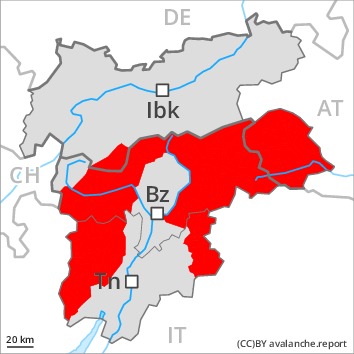
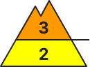
Danger level
 | 2600m
|
Avalanche Problem

New snow and gliding snow are to be critically assessed. Exposed parts of transportation routes can be endangered.
A precarious avalanche situation will be encountered over a wide area. On steep grassy slopes wet and gliding avalanches are to be expected at any time, even very large ones in isolated cases. This applies in all aspects below approximately 2600 m.
The new snow and wind slabs of the last few days can be released easily, even by a single winter sport participant, in all aspects above the tree line. The number and size of avalanche prone locations will increase with altitude. With the end of the intense precipitation, the natural avalanche activity will gradually decrease [Emtpy].
The current avalanche situation calls for very extensive experience in the assessment of avalanche danger and great restraint.
Snowpack
dp.2: gliding snow
dp.6: cold, loose snow and wind
Over a wide area 120 to 180 cm of snow, and even more in some localities, has fallen since Friday. 5 to 15 cm of snow will fall on Monday. Over a wide area moderate southeasterly wind. The sometimes storm force wind has transported a lot of snow. In many cases new snow and wind slabs are lying on soft layers. This applies at high altitudes and in high Alpine regions. The rain gave rise on Sunday to a loss of strength within the snowpack especially at low and intermediate altitudes.
Tendency
Further decrease in avalanche danger. Caution is to be exercised in areas with glide cracks.
Danger level
 | 2600m
|
Avalanche Problem
Gliding snow is to be evaluated critically. Exposed parts of transportation routes can be endangered.
A precarious avalanche situation will persist in some regions. On steep grassy slopes wet and gliding avalanches are to be expected at any time, even large ones. This applies in all aspects below approximately 2600 m.
The new snow and wind slabs of the last few days can be released easily, even by a single winter sport participant, in all aspects above the tree line. The number and size of avalanche prone locations will increase with altitude. With the end of the intense precipitation, the natural avalanche activity will gradually decrease [Emtpy].
The current avalanche situation calls for extensive experience in the assessment of avalanche danger and great restraint. In the regions exposed to heavier precipitation the avalanche danger is a little higher.
Snowpack
dp.2: gliding snow
dp.6: cold, loose snow and wind
Over a wide area 80 to 130 cm of snow, and even more in some localities, has fallen since Friday. 5 to 15 cm of snow will fall on Monday. Over a wide area moderate southeasterly wind. The sometimes storm force wind has transported a lot of snow. New snow and wind slabs are lying on soft layers. This applies at high altitudes and in high Alpine regions. The rain gave rise on Sunday to a loss of strength within the snowpack especially at low and intermediate altitudes.
Tendency
Further decrease in avalanche danger. Caution is to be exercised in areas with glide cracks.
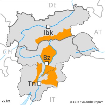
Danger level
 | treeline
|
Avalanche Problem
 | | Wind-drifted snow |
|  | |  |
 | | Gliding snow |
|  | | |
Wind slabs and gliding snow represent the main danger.
Especially on steep grassy slopes individual small and, in isolated cases, medium-sized gliding avalanches are possible.
Snowpack
dp.6: cold, loose snow and wind
dp.2: gliding snow
Over a wide area 30 to 50 cm of snow, and even more in some localities, has fallen thus far. 5 to 15 cm of snow will fall on Monday.
The sometimes storm force wind has transported a lot of snow. The covering of new snow is moist and has a loosely bonded surface. This applies in the regions exposed to precipitation in particular at intermediate altitudes.
Tendency
The avalanche danger will decrease gradually.

