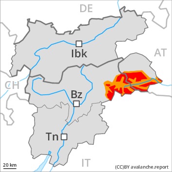
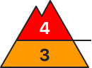
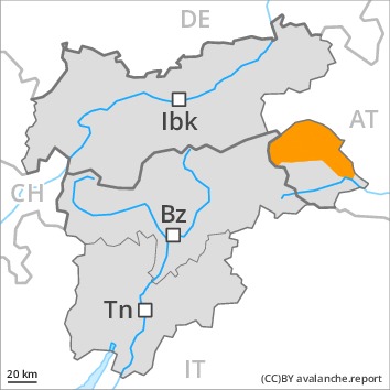
Danger level
 | treeline
|
Avalanche Problem

Increase in avalanche danger as the precipitation becomes more intense.
Fresh snow and large quantities of wind-drifted snow represent the main danger. The fresh snow and the sometimes deep wind slabs can be released easily in all aspects above the tree line. The avalanche prone locations are sometimes covered with new snow and are difficult to recognise. Caution is to be exercised in all aspects also in areas close to the tree line. On wind-loaded slopes natural dry avalanches are to be expected from the second half of the night, even large ones in isolated cases.
As a consequence of the heavy precipitation gliding avalanches are possible, even large ones in isolated cases. This applies in particular at low and intermediate altitudes.
Caution and restraint are important.
Snowpack
dp.6: cold, loose snow and wind
dp.2: gliding snow
Over a wide area 50 to 80 cm of snow will fall. The strong wind will transport the fresh and old snow significantly. In some places new snow and wind slabs are lying on soft layers.
In its middle, the snowpack is faceted. Towards its base, the snowpack is largely stable. The high temperatures gave rise to slight softening of the snowpack over a wide area at low altitude.
Tendency
Slight decrease in avalanche danger as the precipitation eases.
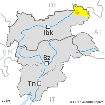
Danger level
| treeline
|
Avalanche Problem
 | | New snow |
|  | |  |
 | | Persistent weak layer |
|  | | |
New snow and weakly bonded old snow represent the main danger.
Avalanches can in some cases be released in deep layers and reach large size in isolated cases, in particular in places that are protected from the wind as well as in areas close to the tree line. Caution is to be exercised in areas where the snow cover is rather shallow, as well as at transitions from a shallow to a deep snowpack. Remotely triggered avalanches are possible. Natural avalanches are possible, in particular on steep shady slopes.
The fresh snow and the sometimes large wind slabs can be released easily, even by a single winter sport participant, in all aspects. The number and size of avalanche prone locations will increase with altitude.
Caution and restraint are important.
Snowpack
dp.6: cold, loose snow and wind
dp.7: snow-poor zones in snow-rich surrounding
The old snowpack is faceted and weak, in particular in areas where the snow cover is rather shallow, as well as at transitions from a shallow to a deep snowpack. Whumpfing sounds and stability tests confirm the unfavourable bonding of the snowpack.
In particular on the Main Alpine Ridge up to 50 cm of snow, and even more in some localities, will fall. As a consequence of new snow and a strengthening wind from variable directions, avalanche prone wind slabs will form in places that are protected from the wind. In some places new snow and wind slabs are lying on soft layers.
Tendency
Slight decrease in danger.
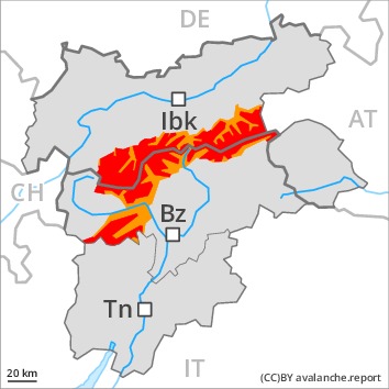
Danger level
Avalanche Problem
| | Persistent weak layer |
| | | |
 | | Wind-drifted snow |
| | | |
Weakly bonded old snow requires caution. Wind slabs are to be evaluated critically.
Avalanches can in some cases be released in deep layers and reach large size in isolated cases. Caution is to be exercised in particular at transitions from a shallow to a deep snowpack as well as in areas close to the tree line. Remotely triggered avalanches are possible. More natural avalanches are possible, but they will be mostly small. This applies especially on steep shady slopes.
As a consequence of a sometimes storm force wind from variable directions, avalanche prone wind slabs formed. Avalanches can be released, even by a single winter sport participant and reach medium size, especially on west, north and east facing slopes above the tree line. The number and size of avalanche prone locations will increase with altitude.
Areas close to the tree line and above the tree line: Caution and restraint are important. Below the tree line the situation is significantly more favourable.
Snowpack
dp.6: cold, loose snow and wind
Up to 20 cm of snow will fall until midday above approximately 1500 m. The strong wind will transport the fresh and old snow significantly. In some places new snow and wind slabs are lying on soft layers. The old snowpack is faceted. Whumpfing sounds and stability tests confirm the unfavourable bonding of the snowpack.
Some rain will fall until late in the night. This applies in particular below approximately 1500 m. The rain will give rise to softening of the snowpack over a wide area in particular at low altitude. Towards its surface, the snowpack is moist.
Tendency
Hardly any decrease in avalanche danger.
Danger level
 | treeline
|
Avalanche Problem
Increase in avalanche danger as a consequence of new snow and strong wind.
Fresh snow and large quantities of wind-drifted snow represent the main danger. The fresh wind slabs can be released easily in all aspects at high altitudes and in high Alpine regions. The avalanche prone locations are sometimes covered with new snow and are difficult to recognise. As a consequence of new snow and wind natural dry avalanches are possible from the second half of the night, in particular medium-sized ones.
Avalanches can in some cases be triggered in deep layers and reach large size. Caution is to be exercised in all aspects also in areas close to the tree line.
As a consequence of the precipitation more frequent gliding avalanches are possible, even large ones in isolated cases.
Caution and restraint are important.
Snowpack
dp.6: cold, loose snow and wind
dp.2: gliding snow
Over a wide area 30 to 50 cm of snow, and even more in some localities, will fall. As a consequence of a strong wind from variable directions, further wind slabs will form. The snowpack will be subject to considerable local variations. The new snow and wind slabs will be deposited on soft layers on steep shady slopes. Adjacent to ridgelines in all aspects: In many cases new snow and wind slabs are lying on a hard crust. In its middle, the snowpack is faceted.
Tendency
Hardly any decrease in danger.

Danger level
Avalanche Problem
| | Persistent weak layer |
| | | |
| | Wind-drifted snow |
| | | |
Weakly bonded old snow requires caution. Wind slabs are to be evaluated critically.
Avalanches can in some cases be released in deep layers and reach large size in isolated cases, this also applies in areas close to the tree line, caution is to be exercised in areas where the snow cover is rather shallow, as well as at transitions from a shallow to a deep snowpack. Remotely triggered avalanches are possible. As a consequence of new snow and wind more natural avalanches are possible, even medium-sized ones. This applies especially on steep shady slopes.
As a consequence of a sometimes storm force wind from variable directions, avalanche prone wind slabs formed. These can be released even by a single winter sport participant especially on west to north to east facing aspects above the tree line. Mostly avalanches are medium-sized. The number and size of avalanche prone locations will increase with altitude.
Areas close to the tree line and above the tree line: Caution and restraint are important. Below the tree line the situation is more favourable.
Snowpack
dp.6: cold, loose snow and wind
dp.7: snow-poor zones in snow-rich surrounding
Over a wide area 10 to 30 cm of snow will fall until midday above approximately 1500 m. The strong wind will transport the fresh and old snow significantly. In some places new snow and wind slabs are lying on soft layers. The old snowpack is faceted. Whumpfing sounds and stability tests confirm the unfavourable bonding of the snowpack.
Some rain will fall until late in the night. This applies in particular below approximately 1500 m. The rain will give rise to softening of the snowpack over a wide area in particular at low altitude.
Tendency
Hardly any decrease in avalanche danger.
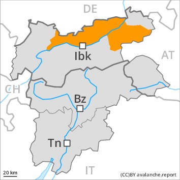
Danger level
 | treeline
|
Avalanche Problem
| | Wind-drifted snow |
| | |  |
| | Wind-drifted snow |
|  | |  |
Wind slabs are to be evaluated with care and prudence.
As a consequence of a sometimes storm force wind from variable directions, avalanche prone wind slabs formed in the last few days. Avalanches can in some places be released, even by a single winter sport participant and reach medium size, especially on steep west, north and east facing slopes above the tree line, as well as on steep shady slopes below the tree line. The number and size of avalanche prone locations will increase with altitude. Below the tree line the avalanche danger is lower.
Snowpack
dp.6: cold, loose snow and wind
Up to 10 cm of snow will fall until midday above approximately 1500 m. As a consequence of a strong wind from variable directions, sometimes avalanche prone wind slabs will form in particular on west, north and east facing slopes. In isolated cases various wind slab layers are lying on a weakly bonded old snowpack, in particular on shady slopes also in areas close to the tree line. As a consequence of mild temperatures the snowpack will settle.
Some rain will fall until late in the night. This applies in particular below approximately 1500 m. The rain will give rise to softening of the snowpack over a wide area in particular at low altitude.
Tendency
Hardly any decrease in danger.
