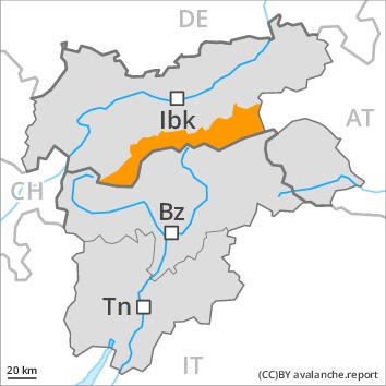
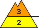
Danger level
Avalanche Problem
 | | Persistent weak layer |
|  | |  |
 | | Wind-drifted snow |
|  | | |

Wind slabs and weakly bonded old snow represent the main danger.
Avalanches can in some cases be released in deep layers and reach large size in isolated cases, in particular in places that are protected from the wind as well as in areas close to the tree line. Caution is to be exercised in areas where the snow cover is rather shallow, as well as at transitions from a shallow to a deep snowpack. Remotely triggered avalanches are possible in isolated cases. This applies in all aspects.
The fresh and older wind slabs can be released easily, even by a single winter sport participant, in all aspects above the tree line. Caution is to be exercised at their margins in particular. The number and size of avalanche prone locations will increase with altitude. The avalanche prone locations are sometimes covered with new snow and are therefore difficult to recognise.
Extensive experience in the assessment of avalanche danger and great restraint are required.
Snowpack
dp.6: cold, loose snow and wind
dp.7: snow-poor zones in snow-rich surrounding
The old snowpack is faceted and weak, in particular in areas where the snow cover is rather shallow, as well as at transitions from a shallow to a deep snowpack. Whumpfing sounds and released avalanches confirm the unfavourable bonding of the snowpack.
10 to 15 cm of snow will fall. As a consequence of new snow and wind from variable directions, further wind slabs will form in all aspects. In some places new snow and wind slabs are lying on soft layers.
Tendency
Hardly any decrease in danger.
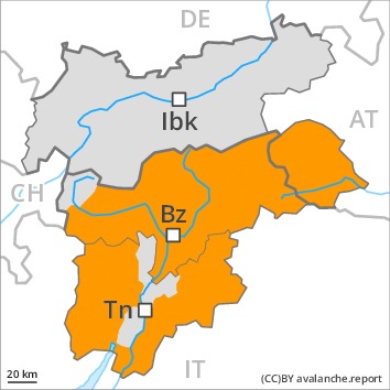
Danger level
 | treeline
|
Avalanche Problem
| | Wind-drifted snow |
| | | |
| | Persistent weak layer |
| | | |
In all aspects a considerable avalanche danger will prevail. Natural avalanches are still possible in isolated cases.
Fresh snow and large quantities of wind-drifted snow remain for the foreseeable future prone to triggering. Medium-sized and, in isolated cases, large natural avalanches are possible in isolated cases. In the regions exposed to a lot of wind this applies in particular. The fresh snow of the weekend and the sometimes deep wind slabs can be released easily in all aspects and generally above the tree line. Remotely triggered avalanches are possible. The avalanche prone locations are sometimes covered with new snow and are difficult to recognise.
In the regions with a lot of snow gliding avalanches are possible, even quite large ones. This applies in particular at low and intermediate altitudes.
The conditions are precarious for snow sport activities. Caution and restraint are recommended.
Snowpack
dp.6: cold, loose snow and wind
dp.2: gliding snow
A lot of snow fell in the last few days over a wide area. The strong wind has transported the new snow. In some places new snow and wind slabs are lying on soft layers.
In its middle, the snowpack is unfavourably layered. Towards its base, the snowpack is largely stable.
Tendency
The avalanche danger will persist.
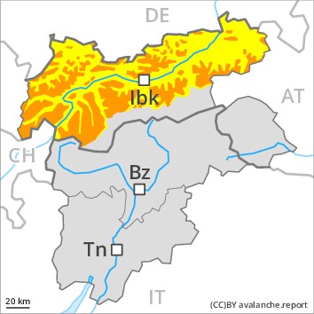
Danger level
 | 1600m
|
Avalanche Problem
| | Wind-drifted snow |
| | | |
| | Persistent weak layer |
| | | |
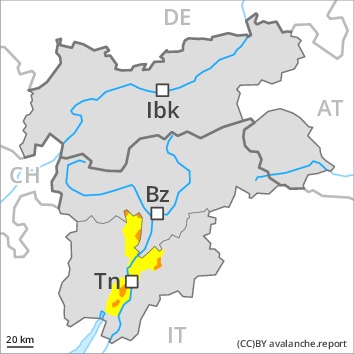
Weakly bonded old snow requires caution. Wind slabs are to be evaluated critically.
As a consequence of a sometimes strong wind from variable directions, avalanche prone wind slabs formed in the last few days. These remain for the foreseeable future prone to triggering in all aspects above the tree line. Mostly avalanches are medium-sized. The number and size of avalanche prone locations will increase with altitude. The avalanche prone locations are sometimes covered with new snow.
Additionally avalanches can also be released in deep layers and reach large size in isolated cases, in particular in areas where the snow cover is rather shallow, as well as at transitions from a shallow to a deep snowpack. Remotely triggered avalanches are possible.
Areas close to the tree line and above the tree line: Caution and restraint are important. Below approximately 1600 m the situation is more favourable.
Snowpack
dp.6: cold, loose snow and wind
dp.7: snow-poor zones in snow-rich surrounding
In particular in the Allgäu Alps, in the Lechtal Alps and in the Mangfall Range up to 20 cm of snow will fall until Tuesday. In the other regions 10 to 15 cm of snow will fall. The wind will be moderate to strong. The weather conditions will prevent a stabilisation of the snowpack. As a consequence of low temperatures and the moderate to strong northwesterly wind, fresh snow drift accumulations will form. Distinct weak layers exist in the centre of the snowpack. The old snowpack is faceted. Released avalanches and field observations confirm the unfavourable bonding of the snowpack.
Tendency
Hardly any decrease in avalanche danger.
Danger level
| treeline
|
Avalanche Problem
| | Wind-drifted snow |
| | | |
| | Persistent weak layer |
| | | |
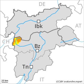
Increase in avalanche danger as a consequence of new snow and strong wind. Fresh wind slabs require caution.
Fresh snow and large quantities of wind-drifted snow represent the main danger. The fresh wind slabs can be released easily in all aspects at high altitudes and in high Alpine regions. The avalanche prone locations are sometimes covered with new snow and are difficult to recognise. On wind-loaded slopes natural dry avalanches are possible as the day progresses, in particular medium-sized ones.
Avalanches can in some cases be triggered in deep layers and reach large size. Caution is to be exercised in all aspects also in areas close to the tree line.
Gliding avalanches are possible.
Caution and restraint are important.
Snowpack
dp.6: cold, loose snow and wind
dp.3: rain
Over a wide area 20 to 40 cm of snow, and even more in some localities, has fallen. As a consequence of a strong northerly wind, further wind slabs will form. The brittle wind slabs are barely recognisable because of the poor visibility. The old snowpack will be in some cases prone to triggering. Towards its surface, the snowpack is moist and its surface consists of loosely bonded snow lying on a crust that is not capable of bearing a load.
Tendency
Fresh wind slabs require caution. The avalanche danger will increase.
Danger level
| treeline
|
Avalanche Problem
| | Persistent weak layer |
| | | |
| | Wind-drifted snow |
| | | |
Wind slabs are to be evaluated with care and prudence.
Avalanches can in some cases be released in deep layers and reach large size in isolated cases, this also applies in areas close to the tree line, caution is to be exercised in areas where the snow cover is rather shallow, as well as at transitions from a shallow to a deep snowpack. Remotely triggered avalanches are possible.
As a consequence of new snow and a sometimes strong wind from variable directions, avalanche prone wind slabs formed in the last few days in particular in gullies and bowls and behind abrupt changes in the terrain. These can be released even by a single winter sport participant in all aspects and generally above the tree line. Mostly avalanches are medium-sized. The number and size of avalanche prone locations will increase with altitude.
Below the tree line the situation is more favourable.
Snowpack
dp.6: cold, loose snow and wind
dp.7: snow-poor zones in snow-rich surrounding
The strong wind has transported the new snow significantly. Over a wide area wind slabs are lying on old snow containing large grains. The old snowpack is faceted. Whumpfing sounds and stability tests confirm the unfavourable bonding of the snowpack.
Tendency
Hardly any decrease in avalanche danger. On Monday it will be cold.