Danger level
Avalanche Problem
 | | Persistent weak layer |
|  | |  |
 | | Wind-drifted snow |
|  | | |

Wind slabs and weakly bonded old snow represent the main danger.
Avalanches can in some cases be released in deep layers and reach large size in isolated cases, in particular in places that are protected from the wind as well as in areas close to the tree line. Caution is to be exercised in areas where the snow cover is rather shallow, as well as at transitions from a shallow to a deep snowpack. Remotely triggered avalanches are possible in isolated cases. This applies in all aspects.
The fresh and older wind slabs can be released easily, even by a single winter sport participant, in all aspects above the tree line. Caution is to be exercised at their margins in particular. The number and size of avalanche prone locations will increase with altitude. The avalanche prone locations are sometimes covered with new snow and are therefore difficult to recognise.
Extensive experience in the assessment of avalanche danger and great restraint are required.
Snowpack
dp.6: cold, loose snow and wind
dp.7: snow-poor zones in snow-rich surrounding
The weather conditions will prevent a change towards better conditions. The wind will be moderate to strong. The old snowpack is faceted and weak, in particular in areas where the snow cover is rather shallow, as well as at transitions from a shallow to a deep snowpack. Avalanches can be released in near-ground layers. Whumpfing sounds and released avalanches confirm the unfavourable bonding of the snowpack.
Distinct weak layers exist in the centre of the snowpack. These can still be released in some cases. In the regions with a lot of snow the snowpack is less prone to triggering.
Tendency
In some regions increase in danger as a consequence of new snow and strong wind.
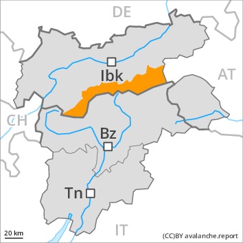
Danger level
Avalanche Problem
| | Wind-drifted snow |
| | | |
| | Persistent weak layer |
| | | |
Fresh wind slabs represent the main danger. Weakly bonded old snow requires caution.
As a consequence of a sometimes strong wind from variable directions, avalanche prone wind slabs formed in the last few days. Fresh and older wind slabs remain for the foreseeable future prone to triggering in all aspects above the tree line. Single winter sport participants can release avalanches as before. Mostly avalanches are medium-sized. The number and size of avalanche prone locations will increase with altitude.
Avalanches can in some cases be released in deep layers and reach large size in isolated cases, in particular in areas where the snow cover is rather shallow, as well as at transitions from a shallow to a deep snowpack. Remotely triggered avalanches are possible.
Caution and restraint are important.
Snowpack
dp.6: cold, loose snow and wind
dp.7: snow-poor zones in snow-rich surrounding
The weather conditions will prevent a change towards better conditions. More snow than expected has fallen in some regions. Up to 30 cm of snow, and even more in some localities, fell in the past few hours in all altitude zones. The wind will be moderate to strong. As a consequence of new snow and a moderate to strong northwesterly wind, further wind slabs will form.
Distinct weak layers exist in the centre of the snowpack. These can be released in some cases. Towards its base, the snowpack is faceted and weak. Avalanches can be released in near-ground layers, especially at transitions from a shallow to a deep snowpack, as well as in areas where the snow cover is rather shallow. Released avalanches and field observations confirm the unfavourable bonding of the snowpack.
Tendency
In some regions increase in avalanche danger as a consequence of new snow and strong wind.
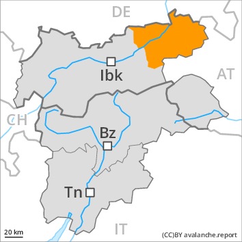
Danger level
Avalanche Problem
| | Persistent weak layer |
| | | |
| | Wind-drifted snow |
| | | |
A sometimes precarious avalanche situation will prevail. Natural avalanches are possible in isolated cases.
The fresh snow of last week and the sometimes deep wind slabs can be released easily in all aspects and generally above the tree line. Avalanches can also be released in the old snowpack and reach quite a large size. Remotely triggered avalanches are possible. The avalanche prone locations are sometimes covered with new snow and are difficult to recognise. Below the tree line the avalanche situation is more favourable. As a consequence of new snow and wind individual natural avalanches are possible, in particular in the regions exposed to heavier precipitation. This applies in particular on steep east, south and southwest facing slopes.
In the regions with a lot of snow gliding avalanches are possible, even quite large ones. This applies in particular at low and intermediate altitudes.
The conditions are precarious for snow sport activities. Caution and restraint are recommended.
Snowpack
dp.6: cold, loose snow and wind
dp.2: gliding snow
On the Main Alpine Ridge 5 to 15 cm of snow will fall. The strong wind will transport the fresh and old snow. In some places new snow and wind slabs are lying on soft layers.
In its middle, the snowpack is weak. Towards its base, the snowpack is largely stable. Whumpfing sounds and the formation of shooting cracks when stepping on the snowpack serve as an alarm indicating the danger. Released avalanches and reports filed by observers confirm the existence of a weak snowack.
Tendency
A precarious avalanche situation will persist in some cases.
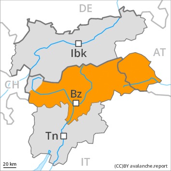
Danger level
 | 1600m
|
Avalanche Problem
| | Persistent weak layer |
| | | |
| | Wind-drifted snow |
| | | |
Weakly bonded old snow requires caution. Wind slabs are to be evaluated critically.
Avalanches can in some cases be released in deep layers and reach large size in isolated cases, in particular in areas where the snow cover is rather shallow, as well as at transitions from a shallow to a deep snowpack. Remotely triggered avalanches are possible.
As a consequence of a sometimes strong wind from variable directions, avalanche prone wind slabs formed in the last few days. Fresh and older wind slabs remain for the foreseeable future prone to triggering in all aspects above the tree line. Mostly avalanches are medium-sized. The number and size of avalanche prone locations will increase with altitude.
Areas close to the tree line and above the tree line: Caution and restraint are important. Below approximately 1600 m the situation is more favourable.
Snowpack
dp.6: cold, loose snow and wind
dp.7: snow-poor zones in snow-rich surrounding
The weather conditions will prevent a change towards better conditions. In particular in the Allgäu Alps, in the Lechtal Alps and in the Mangfall Range 20 to 30 cm of snow will fall until the early morning. In the other regions 10 to 20 cm of snow will fall. The wind will be moderate to strong.
Distinct weak layers exist in the centre of the snowpack. These can be released in some cases. Towards its base, the snowpack is faceted and weak. Avalanches can be released in near-ground layers, especially at transitions from a shallow to a deep snowpack, as well as in areas where the snow cover is rather shallow. Released avalanches and field observations confirm the unfavourable bonding of the snowpack. In the regions with a lot of snow the snowpack is less prone to triggering.
Tendency
In some regions increase in avalanche danger as a consequence of new snow and strong wind.