AM
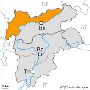
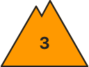
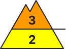
Danger level
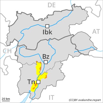
 | treeline
|
Avalanche Problem
 | | Wind-drifted snow |
|  | |  |
 | | Persistent weak layer |
| | | |
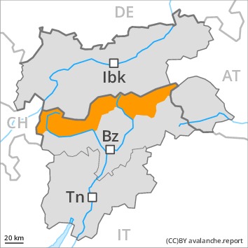
PM

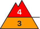
Danger level
 | treeline
|
Avalanche Problem
 | | New snow |
| | | |
| | Persistent weak layer |
| | | |
Towards the evening as a consequence of new snow and wind there will be an increase in the avalanche danger.
The cold fresh snow and the wind slabs that are forming during the snowfall represent the main danger. Fresh and older wind slabs are prone to triggering in all aspects above the tree line. They can be released even by a single winter sport participant. The number and size of avalanche prone locations will increase with altitude.
Additionally avalanches can also be released in deep layers and reach large size in isolated cases, in particular in areas where the snow cover is rather shallow, as well as at transitions from a shallow to a deep snowpack. Remotely triggered avalanches are possible.
Evening and night: In the regions exposed to heavier precipitation natural avalanches must be expected with increasing likelihood. In the regions where a lot of snow falls danger level 4 (high) will be reached earlier.
Snowpack
dp.6: cold, loose snow and wind
dp.7: snow-poor zones in snow-rich surrounding
Over a wide area 20 to 30 cm of snow, and up to 50 cm in some localities, has fallen since Monday. In all regions 20 to 30 cm of snow, and even more in some localities, will fall from late morning. The wind will be strong. Over a wide area new snow and wind slabs are lying on soft layers.
Distinct weak layers exist in the centre of the snowpack. These can be released in some cases. Towards its base, the snowpack is faceted and weak. Avalanches can be released in near-ground layers, especially at transitions from a shallow to a deep snowpack, as well as in areas where the snow cover is rather shallow. Field observations confirm the unfavourable bonding of the snowpack.
Tendency
Further increase in avalanche danger as the snowfall level rises.
Danger level
Avalanche Problem
| | Wind-drifted snow |
|  | | |
| | Persistent weak layer |
| | | |

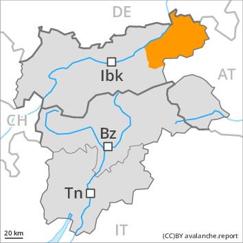
As a consequence of new snow and wind there will be an increase in the danger.
The cold fresh snow and the wind slabs that are forming during the snowfall represent the main danger. Fresh and older wind slabs remain for the foreseeable future prone to triggering in all aspects above the tree line. They can be released even by a single winter sport participant. The number and size of avalanche prone locations will increase with altitude.
Additionally avalanches can also penetrate deep layers and reach large size in isolated cases, in particular at transitions from a shallow to a deep snowpack, as well as adjacent to ridgelines.
As a consequence of new snow and strong wind natural avalanches are possible by the evening.
Snowpack
dp.6: cold, loose snow and wind
In some localities up to 10 cm of snow has fallen since Monday. Along the border with Tirol 10 to 20 cm of snow, and even more in some localities, will fall from late morning. The wind will be strong. Over a wide area new snow and wind slabs are lying on soft layers.
Distinct weak layers exist in the centre of the snowpack. These can be released in some cases. Towards its base, the snowpack is largely stable. Field observations confirm the unfavourable bonding of the snowpack.
Tendency
Further increase in avalanche danger as the snowfall becomes more intense.
Danger level
| treeline
|
Avalanche Problem
| | Wind-drifted snow |
| | | |
| | Persistent weak layer |
| | | |
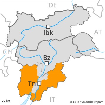
Towards the evening as a consequence of new snow and wind there will be an increase in the avalanche danger.
The cold fresh snow and the wind slabs that are forming during the snowfall represent the main danger. Fresh and older wind slabs are prone to triggering in all aspects above the tree line. They can be released even by a single winter sport participant. The number and size of avalanche prone locations will increase with altitude.
Additionally avalanches can also be released in deep layers and reach large size in isolated cases, in particular in areas where the snow cover is rather shallow, as well as at transitions from a shallow to a deep snowpack.
Evening and night: As a consequence of new snow and strong wind natural avalanches are possible.
Snowpack
dp.6: cold, loose snow and wind
dp.7: snow-poor zones in snow-rich surrounding
Up to 50 cm of snow, and even more in some localities, has fallen since Monday. 20 cm of snow will fall from the afternoon. The wind will be strong. Over a wide area new snow and wind slabs are lying on soft layers.
Distinct weak layers exist in the centre of the snowpack. These can be released in some cases. Towards its base, the snowpack is faceted and weak. Avalanches can be released in near-ground layers, especially at transitions from a shallow to a deep snowpack, as well as in areas where the snow cover is rather shallow. Field observations confirm the unfavourable bonding of the snowpack.
Tendency
Further increase in avalanche danger as the snowfall level rises.
Danger level
Avalanche Problem
| | Persistent weak layer |
| | | |
| | Wind-drifted snow |
| | | |
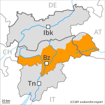
A sometimes precarious avalanche situation will prevail. Natural avalanches are possible in isolated cases.
The fresh snow of last week and the sometimes deep wind slabs can be released easily in all aspects and generally above the tree line. Avalanches can also be released in the old snowpack and reach quite a large size. Remotely triggered avalanches are possible. The avalanche prone locations are sometimes covered with new snow and are difficult to recognise. Below the tree line the avalanche situation is more favourable. As a consequence of new snow and wind individual natural avalanches are possible, in particular in the regions exposed to heavier precipitation. This applies in particular on steep east, south and southwest facing slopes.
In the regions with a lot of snow gliding avalanches are possible, even quite large ones. This applies in particular at low and intermediate altitudes.
The conditions are precarious for snow sport activities. Caution and restraint are recommended.
Snowpack
dp.6: cold, loose snow and wind
dp.2: gliding snow
The strong wind will transport the fresh and old snow. In some places new snow and wind slabs are lying on soft layers.
In its middle, the snowpack is weak. Towards its base, the snowpack is largely stable. Whumpfing sounds and the formation of shooting cracks when stepping on the snowpack serve as an alarm indicating the danger. Released avalanches and reports filed by observers confirm the existence of a weak snowack.
Tendency
A precarious avalanche situation will persist in some cases.
Danger level
| treeline
|
Avalanche Problem
| | Wind-drifted snow |
| | | |
| | Persistent weak layer |
| | | |
In all aspects a considerable avalanche danger will prevail. Natural avalanches are still possible in isolated cases.
Fresh snow and large quantities of wind-drifted snow remain for the foreseeable future prone to triggering. Medium-sized and, in isolated cases, large natural avalanches are possible in isolated cases. In the regions exposed to a lot of wind this applies in particular. The fresh snow of the weekend and the sometimes deep wind slabs can be released easily in all aspects and generally above the tree line. Remotely triggered avalanches are possible. The avalanche prone locations are sometimes covered with new snow and are difficult to recognise.
In the regions with a lot of snow gliding avalanches are possible, even quite large ones. This applies in particular at low and intermediate altitudes.
The conditions are precarious for snow sport activities. Caution and restraint are recommended.
Snowpack
dp.6: cold, loose snow and wind
dp.2: gliding snow
A lot of snow fell in the last few days over a wide area. The strong wind has transported the new snow. In some places new snow and wind slabs are lying on soft layers.
In its middle, the snowpack is unfavourably layered. Towards its base, the snowpack is largely stable.
Tendency
In particular in the north some new snow. On Wednesday the wind slabs will increase in size additionally.
Danger level
| treeline
|
Avalanche Problem
| | Wind-drifted snow |
| | | |
| | Persistent weak layer |
| | | |
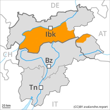
As a consequence of new snow and wind there will be an increase in the danger.
The cold fresh snow and the wind slabs that are forming during the snowfall represent the main danger. Fresh and older wind slabs remain for the foreseeable future prone to triggering in all aspects above the tree line. They can be released even by a single winter sport participant, especially in gullies and bowls, and behind abrupt changes in the terrain. The number and size of avalanche prone locations will increase with altitude.
Additionally avalanches can also penetrate deep layers and reach large size in isolated cases, in particular in areas where the snow cover is rather shallow, as well as at transitions from a shallow to a deep snowpack.
Evening and night: As a consequence of new snow and strong wind natural avalanches are possible.
Snowpack
dp.6: cold, loose snow and wind
dp.7: snow-poor zones in snow-rich surrounding
Up to 20 cm of snow has fallen since Monday. In all regions 20 to 30 cm of snow, and even more in some localities, will fall from midday. The wind will be strong. Over a wide area new snow and wind slabs are lying on soft layers.
Distinct weak layers exist in the centre of the snowpack. These can be released in some cases. Towards its base, the snowpack is faceted. Field observations confirm the unfavourable bonding of the snowpack.
Tendency
Further increase in avalanche danger as the snowfall level rises.
Danger level
 | treeline
|
Avalanche Problem
| | Wind-drifted snow |
| | | |
| | Persistent weak layer |
| | | |
Increase in avalanche danger as a consequence of new snow and strong wind. Fresh wind slabs require caution.
Fresh snow and large quantities of wind-drifted snow represent the main danger. The fresh wind slabs can be released easily in all aspects at high altitudes and in high Alpine regions. The avalanche prone locations are sometimes covered with new snow and are difficult to recognise. On wind-loaded slopes natural dry avalanches are possible as the day progresses, in particular medium-sized ones.
Avalanches can in some cases be triggered in deep layers and reach large size. Caution is to be exercised in all aspects also in areas close to the tree line.
Gliding avalanches are possible.
Caution and restraint are important.
Snowpack
dp.6: cold, loose snow and wind
dp.3: rain
As a consequence of a strong northerly wind, further wind slabs will form. The brittle wind slabs are to be avoided whenever possible in all aspects. The old snowpack will be in some cases prone to triggering.
Tendency
On Wednesday the wind slabs will increase in size additionally.