AM
Danger level
 | treeline
|
Avalanche Problem
 | | New snow |
|  | |  |
 | | Persistent weak layer |
| | | |
PM
Danger level
 | treeline
|
Avalanche Problem
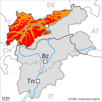
Natural avalanches are to be expected.
As a consequence of new snow and stormy weather there will be an appreciable increase in the avalanche danger. Rain to intermediate altitudes.
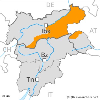
As a consequence of new snow and strong wind a large number of natural avalanches are to be expected as the day progresses, even very large ones in isolated cases. This applies in particular in the west and in the north.
Fresh and older wind slabs are prone to triggering in all aspects above the tree line. They can be released even by a single winter sport participant. The number and size of avalanche prone locations will increase with altitude.
As a consequence of the rain numerous wet and gliding avalanches are to be expected, even quite large ones.
Exposed parts of transportation routes can be endangered.
Snowpack
dp.6: cold, loose snow and wind
dp.3: rain
Over a wide area 30 to 50 cm of snow, and up to 70 cm in some localities, has fallen since Monday. In the Silvretta, in the Western Verwall Mountains and in the Central Lechtal Alps 40 to 60 cm of snow, and even more in some localities, will fall until Friday. In the other regions 20 to 30 cm of snow will fall. The wind will be strong. Over a wide area new snow and wind slabs are lying on soft layers.
Distinct weak layers exist in the centre of the snowpack. Towards its base, the snowpack is faceted and weak.
The rain will give rise as the day progresses to a loss of strength within the snowpack at low and intermediate altitudes.
Tendency
A critical avalanche situation will be encountered over a wide area.
AM
Danger level
 | treeline
|
Avalanche Problem
 | | Wind-drifted snow |
| | | |
| | Persistent weak layer |
| | | |
PM
Danger level
| treeline
|
Avalanche Problem
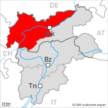
Natural avalanches are to be expected.
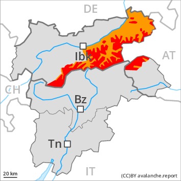
As the day progresses as a consequence of new snow and stormy weather there will be an increase in the avalanche danger to level 4 (high).
As a consequence of new snow and strong wind numerous natural avalanches are to be expected as the day progresses, even quite large ones. In addition at low and intermediate altitudes, numerous medium-sized and large wet and gliding avalanches are to be expected. In the regions exposed to rain this applies.
Fresh and older wind slabs will become increasingly prone to triggering in all aspects above the tree line. They can be released even by a single winter sport participant. Additionally avalanches can also penetrate deep layers and reach large size in isolated cases. The number and size of avalanche prone locations will increase with altitude.
Snowpack
dp.6: cold, loose snow and wind
dp.3: rain
In particular in the Weißkugel Range, in the Central Stubai Alps and in the Eastern Tuxer Alps 40 to 60 cm of snow will fall until Friday. In the other regions over a wide area 20 to 30 cm of snow will fall. The wind will be strong to storm force. Over a wide area new snow and wind slabs are lying on soft layers. Distinct weak layers exist in the centre of the snowpack. These can be released. Caution is to be exercised at their margins in particular. Towards its base, the snowpack is faceted.
The rain will give rise as the day progresses to a loss of strength within the snowpack at low and intermediate altitudes.
Tendency
A critical avalanche situation will be encountered over a wide area.
AM
Danger level
Avalanche Problem
| | Wind-drifted snow |
|  | | |
| | Persistent weak layer |
| | | |
PM
Danger level
| treeline
|
Avalanche Problem
| | Wind-drifted snow |
| | | |
| | Persistent weak layer |
| | | |
As the day progresses as a consequence of new snow and stormy weather there will be a gradual increase in the avalanche danger to level 4 (high).
The cold fresh snow and the wind slabs that are forming during the snowfall represent the main danger. Fresh and older wind slabs will become increasingly prone to triggering in all aspects above the tree line. They can be released even by a single winter sport participant. The number and size of avalanche prone locations will increase with altitude.
Additionally avalanches can also penetrate deep layers and reach large size in isolated cases, in particular at transitions from a shallow to a deep snowpack, as well as adjacent to ridgelines.
As a consequence of new snow and strong wind natural avalanches are possible at any time, even quite large ones.
Snowpack
dp.6: cold, loose snow and wind
In particular along the border with Tirol and Begin: South Tyrol 10 to 30 cm of snow, and even more in some localities, will fall until Friday. The wind will be strong to storm force. Over a wide area new snow and wind slabs are lying on soft layers.
Distinct weak layers exist in the centre of the snowpack. These can be released. Caution is to be exercised at their margins in particular. Towards its base, the snowpack is largely stable.
Tendency
Slight increase in avalanche danger as a consequence of warming.
Danger level
| treeline
|
Avalanche Problem
| | Wind-drifted snow |
| | | |
| | Persistent weak layer |
| | | |

As a consequence of the strong to storm force northwesterly wind the size of the avalanche prone locations will increase.
The fresh snow of the last few days and the sometimes large wind slabs to be found in all aspects can be released easily or naturally in all aspects. Caution is to be exercised in case of releases originating from, high-altitude starting zones that have retained the snow thus far, especially in the regions neighbouring those that are subject to danger level 4 (high). Avalanches can also be released in the old snowpack and reach quite a large size. Remotely triggered avalanches are possible. Below the tree line the avalanche situation is more favourable. As a consequence of new snow and wind individual natural avalanches are possible.
In the regions with a lot of snow gliding avalanches are possible, even quite large ones. This applies in particular at low and intermediate altitudes.
The conditions are precarious for snow sport activities. Caution and restraint are recommended.
Snowpack
dp.6: cold, loose snow and wind
dp.2: gliding snow
In particular in the regions neighbouring those that are subject to danger level 4 (high) 10 to 20 cm of snow will fall from early morning. The strong wind will transport the fresh and old snow. The various wind slabs have bonded insufficiently together. In some places new snow and wind slabs are lying on soft layers.
In its middle, the snowpack is weak. Towards its base, the snowpack is largely stable. Whumpfing sounds and the formation of shooting cracks when stepping on the snowpack serve as an alarm indicating the danger.
Tendency
A precarious avalanche situation will persist in some cases. Temporary increase in danger of dry and moist avalanches as a consequence of warming, in particular below approximately 2400 m.
Danger level
| treeline
|
Avalanche Problem
| | Wind-drifted snow |
| | | |
| | Persistent weak layer |
| | | |
Wind slabs require caution.
The fresh wind slabs represent the main danger. The fresh snow of the weekend and the sometimes deep wind slabs can be released easily in all aspects and generally above the tree line. Natural avalanches are possible in isolated cases. Remotely triggered avalanches are possible.
In the regions with a lot of snow gliding avalanches are possible, even quite large ones. This applies in particular at low and intermediate altitudes.
The conditions are precarious for snow sport activities. Caution and restraint are recommended. As a consequence of warming individual natural avalanches are possible towards the evening.
Snowpack
dp.6: cold, loose snow and wind
dp.2: gliding snow
The strong wind has transported the new snow. In some places new snow and wind slabs are lying on soft layers.
In its middle, the snowpack is unfavourably layered. Towards its base, the snowpack is largely stable.
Tendency
In particular in the north some new snow. On Thursday the wind slabs will increase in size additionally.

