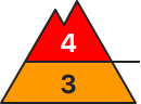
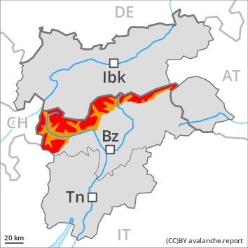
Danger level
 | treeline
|
Avalanche Problem

A critical avalanche situation will persist.
As a consequence of new snow and strong wind more natural avalanches are possible. From starting zones where no previous releases have taken place in particular these can in isolated cases reach very large size. More wet and gliding avalanches are to be expected, even quite large ones. This applies in particular in the west and in the north, in the regions exposed to rain especially. Exposed parts of transportation routes can be endangered in some localities.
The large quantity of fresh snow and the extensive wind slabs formed during the snowfall can be released easily or naturally above the tree line. The number and size of avalanche prone locations will increase with altitude.
Snowpack
dp.6: cold, loose snow and wind
dp.3: rain
Over a wide area 40 to 60 cm of snow, and even more in some localities, has fallen since yesterday. Over a wide area 20 to 30 cm of snow will fall until Saturday. The wind will be strong to storm force. The fresh snow and the resulting extensive wind slabs are lying on soft layers.
Distinct weak layers exist in the centre of the snowpack. Towards its base, the snowpack is faceted and weak.
The rain gave rise to increasing softening of the snowpack especially at low altitude.
Tendency
A critical avalanche situation will persist.
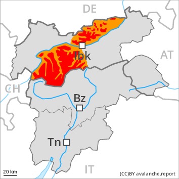
Danger level
 | 1600m
|
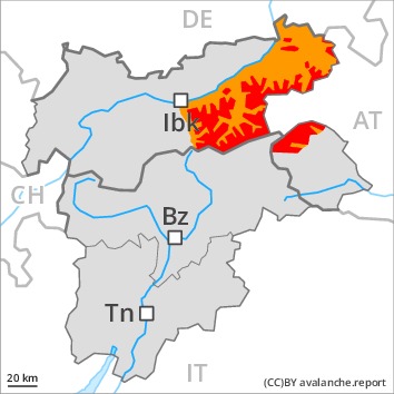
Avalanche Problem
A critical avalanche situation will persist.
More natural avalanches are possible, even quite large ones. In addition at low altitude, medium-sized and large wet and gliding avalanches are possible. In the regions exposed to rain this applies in particular.
The large quantity of fresh snow and the extensive wind slabs formed during the snowfall can be released easily or naturally above the tree line. Additionally avalanches can also penetrate deep layers and reach large size in isolated cases.
The number and size of avalanche prone locations will increase with altitude.
Snowpack
dp.6: cold, loose snow and wind
dp.3: rain
Up to 40 cm of snow has fallen. Over a wide area 20 to 30 cm of snow will fall until Saturday. The wind will be strong to storm force. Over a wide area new snow and wind slabs are lying on soft layers. Distinct weak layers exist in the centre of the snowpack. These can be released. Caution is to be exercised at their margins in particular. Towards its base, the snowpack is faceted.
The rain gave rise to a loss of strength within the snowpack in particular at low altitude.
Tendency
A critical avalanche situation will be encountered over a wide area.
Danger level
| treeline
|
Avalanche Problem
 | | Wind-drifted snow |
|  | |  |
 | | Gliding snow |
|  | | |
The weather report and anticipated change in the avalanche danger are uncertain.
As a consequence of highly fluctuating temperatures rain up to intermediate altitudes and the strong to storm force westerly wind, a very precarious avalanche situation developed. Fresh and older wind slabs are poorly bonded with the old snowpack in all aspects above the tree line. As a consequence of new snow and strong wind natural avalanches are possible at any time, even quite large ones. The fresh wind slabs can be released even by a single winter sport participant. Additionally avalanches can also penetrate deep layers and reach large size in isolated cases.
As the snowfall level rises more frequent medium-sized and, in isolated cases, large moist snow slides and avalanches are possible below approximately 2400 m. Gliding avalanches can also occur. Precautionary safety measures may be necessary in some localities.
Snowpack
dp.6: cold, loose snow and wind
Significant warming: In particular along the border with Tirol and Begin: South Tyrol 5 to 30 cm of snow will fall until Saturday above approximately 2000 m. The snowpack will become moist below approximately 2200 m. The wind will be strong to storm force. Over a wide area new snow and wind slabs are lying on soft layers.
Distinct weak layers exist in the centre of the snowpack. These can be released. Caution is to be exercised at their margins in particular. Towards its base, the snowpack is largely stable.
Tendency
Hardly any decrease in avalanche danger.
Danger level
| treeline
|
Avalanche Problem
A critical avalanche situation will persist.
As a consequence of new snow and strong wind more natural avalanches are possible. From starting zones where no previous releases have taken place in particular these can in isolated cases reach very large size. More wet and gliding avalanches are to be expected, even quite large ones. This applies in particular in the north, in the regions exposed to rain especially. Exposed parts of transportation routes can be endangered in some localities.
The large quantity of fresh snow and the extensive wind slabs formed during the snowfall can be released easily or naturally above the tree line. The number and size of avalanche prone locations will increase with altitude.
Snowpack
dp.6: cold, loose snow and wind
dp.3: rain
Over a wide area 40 to 60 cm of snow, and even more in some localities, has fallen since yesterday. Over a wide area 20 to 30 cm of snow will fall until Saturday. The wind will be strong to storm force. The fresh snow and the resulting extensive wind slabs are lying on soft layers.
Distinct weak layers exist in the centre of the snowpack. Towards its base, the snowpack is faceted and weak.
The rain gave rise to increasing softening of the snowpack especially at low altitude.
Tendency
A critical avalanche situation will persist.
Danger level
 | treeline
|
Avalanche Problem
| | Wind-drifted snow |
| | | |
| | Gliding snow |
| | | |
As a consequence of the moderate to strong northwesterly wind the avalanche prone locations will become more prevalent as the day progresses.
The fresh and older wind slabs represent the main danger. The fresh snow of last week and the sometimes deep wind slabs can be released easily in all aspects and generally above the tree line. Remotely triggered avalanches are possible.
As a consequence of warming individual natural avalanches are possible towards the evening. In the regions with a lot of snow gliding avalanches are possible, even quite large ones. This applies in particular at low and intermediate altitudes.
The conditions are precarious for snow sport activities. Caution and restraint are recommended.
Snowpack
dp.6: cold, loose snow and wind
dp.2: gliding snow
The strong wind has transported the new snow. In some places new snow and wind slabs are lying on soft layers.
In its middle, the snowpack is unfavourably layered. Towards its base, the snowpack is largely stable.
Tendency
In the course of the day the wind slabs will increase in size additionally. A precarious avalanche situation will persist in some cases. Temporary increase in danger of dry and moist avalanches as a consequence of warming, in the event of solar radiation in particular at the base of rock walls.
Danger level
| treeline
|
Avalanche Problem
| | Wind-drifted snow |
| | | |
 | | Persistent weak layer |
|  | | |
The avalanche conditions remain dangerous.
The fresh and somewhat older wind slabs are lying on unfavourable layers in all aspects. They can in many places be released, even by a single winter sport participant or triggered naturally. Caution is to be exercised in case of releases originating from, high-altitude starting zones that have retained the snow thus far, especially in the regions neighbouring those that are subject to danger level 4 (high). Avalanches can also be released in the old snowpack and reach quite a large size. Remotely triggered avalanches are possible.
In the regions with a lot of snow gliding avalanches are possible, even quite large ones. Gradual increase in danger of wet and gliding avalanches as the moisture increases. In the regions where rain falls the avalanche danger is greater. Selective safety measures may be necessary in some localities.
The conditions are precarious for snow sport activities. Caution and restraint are recommended.
Snowpack
dp.6: cold, loose snow and wind
dp.2: gliding snow
The strong wind will transport the fresh and old snow. The various wind slabs have bonded insufficiently together. In some places new snow and wind slabs are lying on soft layers.
In its middle, the snowpack is weak. Towards its base, the snowpack is largely stable. Whumpfing sounds and the formation of shooting cracks when stepping on the snowpack serve as an alarm indicating the danger.
Tendency
A precarious avalanche situation will persist in some cases. Temporary increase in danger of dry and moist avalanches as a consequence of warming, in particular below approximately 2400 m.

