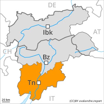
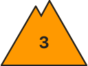
Danger level
 | treeline |
|  |
|  | ||||
|  |
| |


![]()
As a consequence of the sometimes strong northwesterly wind the avalanche prone locations will become more prevalent as the day progresses.
The fresh and older wind slabs represent the main danger. The fresh snow of last week and the sometimes deep wind slabs can be released easily in all aspects and generally above the tree line. Remotely triggered avalanches are possible.
Until the temperature drops more natural avalanches are possible. In the regions with a lot of snow gliding avalanches are possible, even quite large ones. This applies in particular at low and intermediate altitudes.
The conditions are precarious for snow sport activities. Caution and restraint are recommended.
Snowpack
dp.6: cold, loose snow and wind
dp.2: gliding snow
The strong wind has transported the new snow. In some places new snow and wind slabs are lying on soft layers. The surface of the snowpack has frozen to form a strong crust and will soften during the day. This applies in particular at low and intermediate altitudes.
In its middle, the snowpack is unfavourably layered. Towards its base, the snowpack is largely stable.
Tendency
In the course of the day the wind slabs will increase in size additionally. A precarious avalanche situation will persist in some cases. Temporary increase in danger of dry and moist avalanches as a consequence of warming, in the event of solar radiation in particular at the base of rock walls. Over a wide area 10 to 30 cm of snow will fall during the night above approximately 900 m.