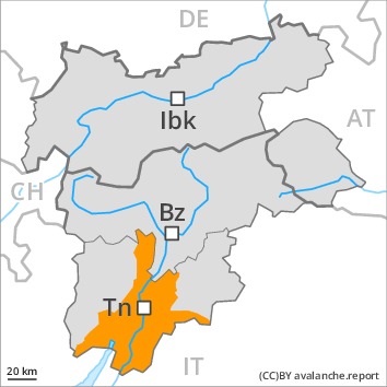
Danger level
Avalanche Problem
 | | Wet snow |
|  | |  |
 | | Gliding snow |
|  | |  |
 | | Wind-drifted snow |
|  | |  |

As a consequence of warming and solar radiation a considerable danger of wet and gliding avalanches will prevail.
As a consequence of warming more frequent moist and wet avalanches are possible at any time, even quite large ones, also on shady slopes adjacent to ridgelines and in gullies and bowls.
As a consequence of a strong wind from southwesterly directions, sometimes avalanche prone wind slabs formed over a wide area, especially on east, north and southeast facing slopes above approximately 2000 m. Caution is to be exercised in particular on very steep slopes, as well as at transitions from a shallow to a deep snowpack.
Snowpack
dp.2: gliding snow
dp.10: springtime scenario
The spring-like weather conditions gave rise to gradual moistening of the snowpack. In particular very steep sunny slopes and low and intermediate altitudes: These meteorological conditions will facilitate a weakening of the snowpack from the early morning in particular on sunny slopes.
As a consequence of a strong southwesterly wind, further wind slabs formed. This applies adjacent to ridgelines in particular above the tree line.
Tendency
Increase in avalanche danger as a consequence of new snow and wind.
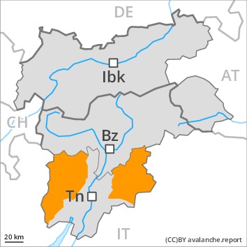
Danger level
 | 2400m
|
Avalanche Problem
| | Wet snow |
| | | |
| | Wind-drifted snow |
| | | |
 | | Persistent weak layer |
| | | |
As a consequence of warming and solar radiation a considerable danger of moist and wet avalanches will prevail. As a consequence of a strong wind, sometimes avalanche prone wind slabs formed at high altitude.
As a consequence of warming moist and wet avalanches are to be expected. Avalanches can also penetrate deep layers and reach dangerously large size. In addition there is a danger of gliding avalanches, this also applies on steep shady slopes.
Weak layers in the old snowpack can still be released in some places by individual winter sport participants. Caution is to be exercised in all aspects above approximately 1900 m, especially on very steep slopes, as well as at transitions from a shallow to a deep snowpack.
In addition the sometimes large wind slabs at high altitudes and in high Alpine regions are prone to triggering in some locations.
Snowpack
dp.7: snow-poor zones in snow-rich surrounding
dp.10: springtime scenario
Towards its base, the snowpack is largely stable. Faceted weak layers exist in the centre of the snowpack, especially above approximately 1900 m.
As a consequence of a strong southwesterly wind, further wind slabs formed, in particular at high altitudes and in high Alpine regions.
The spring-like weather conditions will give rise to gradual moistening of the snowpack. Very steep sunny slopes and low and intermediate altitudes: The snowpack is moist and its surface has a melt-freeze crust that is barely capable of bearing a load.
Tendency
Increase in avalanche danger as a consequence of new snow and wind.