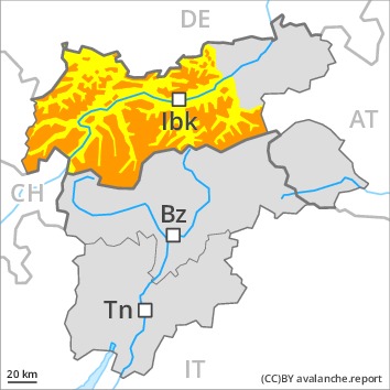
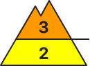
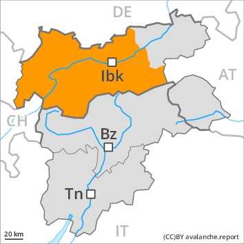
Danger level
Avalanche Problem
 | | Wet snow |
|  | |  |
 | | Gliding snow |
|  | |  |
 | | Wind-drifted snow |
|  | |  |

As a consequence of warming and solar radiation a considerable danger of wet and gliding avalanches will prevail.
As a consequence of warming more frequent moist and wet avalanches are possible at any time, even quite large ones, also on shady slopes adjacent to ridgelines and in gullies and bowls.
As a consequence of a strong wind from southwesterly directions, sometimes avalanche prone wind slabs formed over a wide area, especially on east, north and southeast facing slopes above approximately 2000 m. Caution is to be exercised in particular on very steep slopes, as well as at transitions from a shallow to a deep snowpack.
Snowpack
dp.2: gliding snow
dp.10: springtime scenario
The spring-like weather conditions gave rise to gradual moistening of the snowpack. In particular very steep sunny slopes and low and intermediate altitudes: These meteorological conditions will facilitate a weakening of the snowpack from the early morning in particular on sunny slopes.
As a consequence of a strong southwesterly wind, further wind slabs formed. This applies adjacent to ridgelines in particular above the tree line.
Tendency
Increase in avalanche danger as a consequence of new snow and wind.
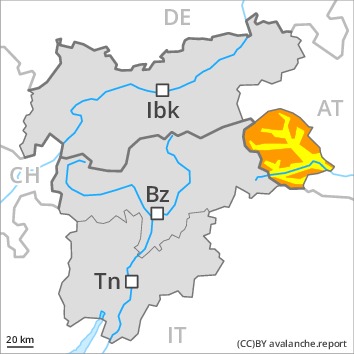
Danger level
 | 2400m
|
Avalanche Problem
| | Wet snow |
| | | |
 | | Persistent weak layer |
| | | |
| | Wind-drifted snow |
| | |  |
During the night as well, wet and gliding avalanches are possible. Weakly bonded old snow is to be evaluated critically.
As a consequence of warming during the day and solar radiation moist and wet avalanches are to be expected. Avalanches can also penetrate deep layers and reach dangerously large size. In addition there is a danger of gliding avalanches, this also applies on steep shady slopes.
Weak layers in the old snowpack can be released in some places even by individual winter sport participants. Caution is to be exercised in all aspects above approximately 1900 m, especially on very steep slopes, as well as at transitions from a shallow to a deep snowpack.
In addition the sometimes large wind slabs at high altitudes and in high Alpine regions are prone to triggering in some locations.
Snowpack
dp.7: snow-poor zones in snow-rich surrounding
dp.10: springtime scenario
The spring-like weather conditions gave rise to increasing moistening of the snowpack below approximately 2400 m. Steep sunny slopes and low and intermediate altitudes: The snowpack is moist and its surface has a melt-freeze crust that is not capable of bearing a load.
Avalanche prone weak layers exist in the centre of the snowpack in all aspects, in particular above approximately 1900 m.
Tendency
Low and intermediate altitudes: Increase in avalanche danger as a consequence of the rain. High altitudes and the high Alpine regions: Increase in avalanche danger as a consequence of new snow and wind.
Danger level
| 2400m
|
Avalanche Problem
| | Wet snow |
| | | |
| | Wind-drifted snow |
| | | |
| | Persistent weak layer |
| | | |
As a consequence of warming and solar radiation a considerable danger of moist and wet avalanches will prevail. As a consequence of a strong wind, sometimes avalanche prone wind slabs formed at high altitude.
As a consequence of warming moist and wet avalanches are to be expected. Avalanches can also penetrate deep layers and reach dangerously large size. In addition there is a danger of gliding avalanches, this also applies on steep shady slopes.
Weak layers in the old snowpack can still be released in some places by individual winter sport participants. Caution is to be exercised in all aspects above approximately 1900 m, especially on very steep slopes, as well as at transitions from a shallow to a deep snowpack.
In addition the sometimes large wind slabs at high altitudes and in high Alpine regions are prone to triggering in some locations.
Snowpack
dp.7: snow-poor zones in snow-rich surrounding
dp.10: springtime scenario
Towards its base, the snowpack is largely stable. Faceted weak layers exist in the centre of the snowpack, especially above approximately 1900 m.
As a consequence of a strong southwesterly wind, further wind slabs formed, in particular at high altitudes and in high Alpine regions.
The spring-like weather conditions will give rise to gradual moistening of the snowpack. Very steep sunny slopes and low and intermediate altitudes: The snowpack is moist and its surface has a melt-freeze crust that is barely capable of bearing a load.
Tendency
Increase in avalanche danger as a consequence of new snow and wind.
AM
Danger level
 | 2000m
|
Avalanche Problem
| | Persistent weak layer |
| | | |
| | Gliding snow |
| | | |
PM
Danger level
| 2400m
|
Avalanche Problem
| | Gliding snow |
| | | |
| | Wet snow |
| | | |
| | Persistent weak layer |
| | | |
As a consequence of warming during the day and solar radiation more frequent wet and gliding avalanches are to be expected. In some places avalanches can be released in the weakly bonded old snow and reach large size.
The avalanche danger will increase quickly during the day. As a consequence of warming during the day and solar radiation more frequent wet loose snow avalanches are to be expected. This applies on extremely steep sunny slopes. Avalanches can also penetrate deep layers and reach dangerously large size.
An appreciable danger of gliding avalanches exists. This applies in particular in the west and in the northwest. Areas with glide cracks are to be avoided.
Dry avalanches can additionally be released in the weakly bonded old snow by a single winter sport participant. This applies above approximately 2000 m, especially in areas where the snow cover is rather shallow, as well as at transitions from a shallow to a deep snowpack. Between approximately 2000 and 2400 m the avalanche prone locations are more prevalent and the danger is slightly greater. Avalanches can penetrate deep layers and reach dangerously large size. Remotely triggered avalanches are possible. Experience and restraint are required.
In particular in the vicinity of peaks sometimes avalanche prone wind slabs formed.
Snowpack
dp.2: gliding snow
dp.10: springtime scenario
The spring-like weather conditions will give rise to increasing moistening of the snowpack, especially at low and intermediate altitudes, as well as on very steep sunny slopes.
Avalanche prone weak layers exist in the centre of the snowpack, especially between approximately 2000 and 2400 m in all aspects. Released avalanches and stability tests confirm the existence of a weak snowack.
Tendency
The danger of wet and gliding avalanches will increase during the day.
AM
Danger level
| 2000m
|
Avalanche Problem
| | Persistent weak layer |
| | | |
| | Gliding snow |
| | | |
PM
Danger level
| 2400m
|
Avalanche Problem
| | Gliding snow |
| | | |
| | Wet snow |
| | | |
| | Persistent weak layer |
| | | |
As the day progresses, wet and gliding avalanches are possible. Weakly bonded old snow requires caution.
The avalanche danger will increase quickly during the day. As a consequence of warming during the day and solar radiation more frequent wet loose snow avalanches are to be expected. This applies on extremely steep sunny slopes. Avalanches can also penetrate deep layers and reach dangerously large size.
In addition a substantial danger of gliding avalanches exists. Areas with glide cracks are to be avoided.
Weak layers in the old snowpack can still be released by individual winter sport participants. Caution is to be exercised in all aspects above approximately 2000 m, especially on very steep slopes, as well as at transitions from a shallow to a deep snowpack.
In addition the fresh wind slabs in high Alpine regions are prone to triggering in some cases, especially adjacent to ridgelines on shady slopes.
Experience in the assessment of avalanche danger is required.
Snowpack
dp.2: gliding snow
dp.10: springtime scenario
The spring-like weather conditions will give rise to increasing moistening of the snowpack. Outgoing longwave radiation during the night will be reduced. The surface of the snowpack is frozen, but not to a significant depth and will soften during the day. This applies in all aspects at low and intermediate altitudes, as well as on very steep sunny slopes also at elevated altitudes.
Faceted weak layers exist in the centre of the snowpack. This applies in particular above approximately 2000 m.
Towards its base, the snowpack is largely stable.
The fresh wind slabs are lying on soft layers in high Alpine regions. This applies on shady slopes.
Tendency
The avalanche danger will increase during the day.
AM
Danger level
 | 2000m
|
Avalanche Problem
| | Persistent weak layer |
| | | |
| | Wet snow |
| | | |
PM
Danger level
| 2400m
|
Avalanche Problem
| | Gliding snow |
| | | |
| | Wet snow |
| | | |
| | Persistent weak layer |
| | | |
As a consequence of warming during the day and solar radiation small to medium-sized wet and gliding avalanches are possible.
As a consequence of warming during the day and solar radiation individual moist avalanches are possible as the day progresses, even medium-sized ones. Caution is to be exercised in particular on extremely steep sunny slopes.
Weak layers in the old snowpack can still be released in some places by individual winter sport participants in particular above approximately 2000 m.
Snowpack
dp.7: snow-poor zones in snow-rich surrounding
dp.10: springtime scenario
Avalanche prone weak layers exist in the centre of the snowpack. This applies in particular above approximately 2000 m. The spring-like weather conditions will give rise to gradual moistening of the snowpack. The snowpack will be moist at intermediate altitudes. The snowpack will be wet all the way through at low altitude.
Tendency
Increase in danger of moist and wet avalanches.