Danger level
 | treeline
|
Avalanche Problem
 | | Wind-drifted snow |
|  | |  |
 | | Wet snow |
|  | | |
 | | Gliding snow |
| | |  |

Significant increase in avalanche danger as a consequence of the precipitation.
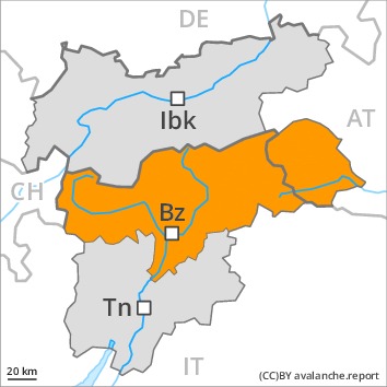
High altitudes and the high Alpine regions: The fresh snow and in particular the sometimes deep wind slabs can be released easily, or, in isolated cases naturally in all aspects. The prevalence of avalanche prone locations and likelihood of triggering will increase as the day progresses. Avalanches can also penetrate deep layers and reach dangerously large size.
Low and intermediate altitudes: As the day progresses as a consequence of the rain there will be a significant increase in the danger of moist and wet avalanches, especially on steep shady slopes. A substantial danger of gliding avalanches exists. Areas with glide cracks are to be avoided as far as possible.
In the regions exposed to heavier precipitation the avalanche prone locations are more prevalent and larger. Extensive experience in the assessment of avalanche danger is required.
Snowpack
dp.6: cold, loose snow and wind
dp.3: rain
15 to 30 cm of snow, and even more in some localities, will fall on Sunday above approximately 1800 m. As a consequence of new snow and a sometimes strong southerly wind, avalanche prone wind slabs will form on Sunday in particular in gullies and bowls and behind abrupt changes in the terrain. The old snowpack is moist, in particular at low and intermediate altitudes, as well as on steep sunny slopes also at high altitude.
Avalanche prone weak layers exist in the centre of the snowpack in all aspects, in particular above approximately 1900 m.
Tendency
Slight decrease in avalanche danger as the precipitation eases.