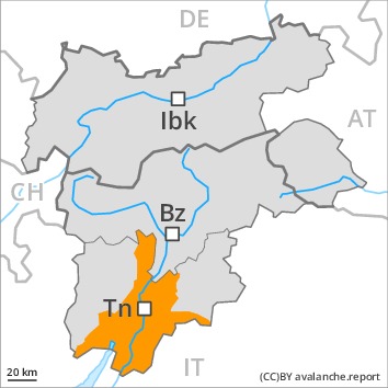
Danger level
 | treeline
|
Avalanche Problem
 | | New snow |
|  | |  |
 | | Wet snow |
|  | | |
 | | Gliding snow |
| | |  |

As a consequence of new snow and wind a considerable avalanche danger will prevail. They can be released, even by small loads in isolated cases.
Over a wide area 20 to 30 cm of snow, and even more in some localities, will fall above approximately 1500 m. The prevalence of avalanche prone locations and likelihood of triggering will increase as the day progresses. The new snow and wind slabs of Sunday can be released by a single winter sport participant in all aspects in all altitude zones, especially on very steep slopes, as well as at transitions from a shallow to a deep snowpack. Avalanches can also penetrate deep layers and reach dangerously large size.
Low and intermediate altitudes: As the day progresses as a consequence of the rain there will be a significant increase in the danger of moist and wet avalanches, especially on steep shady slopes. A substantial danger of gliding avalanches exists. Areas with glide cracks are to be avoided as far as possible.
Snowpack
dp.6: cold, loose snow and wind
dp.3: rain
As a consequence of new snow and a strong southwesterly wind, large surface-area wind slabs will form, in particular adjacent to ridgelines and in gullies and bowls above the tree line. 20 to 30 cm of snow, and even more in some localities, will fall on Sunday above approximately 1500 m. Over a wide area new snow and wind slabs are lying on the smooth surface of an old snowpack. Faceted weak layers exist in the centre of the snowpack, especially above approximately 1900 m. The old snowpack is moist, in particular at low and intermediate altitudes, as well as on steep sunny slopes also at high altitude.
Tendency
Slight decrease in avalanche danger as the precipitation eases.
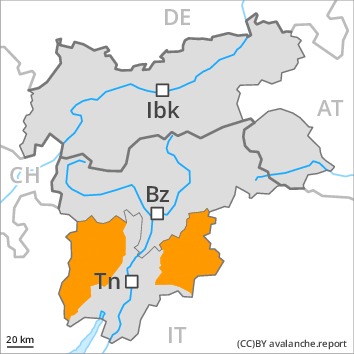
Danger level
Avalanche Problem
| | New snow |
|  | | |
 | | Wind-drifted snow |
| | |  |
| | Wet snow |
| | | |
As a consequence of new snow and wind a considerable avalanche danger will prevail. They can be released, even by small loads in isolated cases.
Over a wide area 20 to 30 cm of snow, and even more in some localities, will fall above approximately 1500 m. The prevalence of avalanche prone locations and likelihood of triggering will increase as the day progresses. The new snow and wind slabs of Sunday can be released by a single winter sport participant in all aspects in all altitude zones, especially on very steep slopes, as well as at transitions from a shallow to a deep snowpack. Avalanches can also penetrate deep layers and reach dangerously large size.
Low and intermediate altitudes: As the day progresses as a consequence of the rain there will be a significant increase in the danger of moist and wet avalanches, especially on steep shady slopes. A substantial danger of gliding avalanches exists. Areas with glide cracks are to be avoided as far as possible.
Snowpack
dp.6: cold, loose snow and wind
dp.3: rain
As a consequence of new snow and a strong southwesterly wind, large surface-area wind slabs will form, in particular adjacent to ridgelines and in gullies and bowls above the tree line. 20 to 30 cm of snow, and even more in some localities, will fall on Sunday above approximately 1500 m. Over a wide area new snow and wind slabs are lying on the smooth surface of an old snowpack. Faceted weak layers exist in the centre of the snowpack, especially above approximately 1900 m. The old snowpack is moist, in particular at low and intermediate altitudes, as well as on steep sunny slopes also at high altitude.
Tendency
Slight decrease in avalanche danger as the precipitation eases.