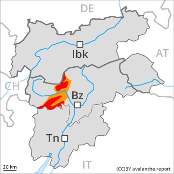
Danger level
 | 2200m
|
Avalanche Problem
 | | New snow |
|  | |  |
 | | Gliding snow |
|  | |  |
 | | Persistent weak layer |
|  | | |

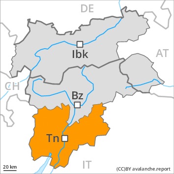
At elevated altitudes a critical avalanche situation will be encountered in some regions.
High altitudes and the high Alpine regions: The large quantity of fresh snow and in particular the sometimes deep wind slabs can be released easily, or, in isolated cases naturally in all aspects. The number and size of avalanche prone locations will increase with altitude. On steep sunny slopes individual loose snow avalanches are possible. Avalanches can also penetrate deep layers and reach large size.
Low and intermediate altitudes: As the snowfall level drops there will be a gradual decrease in the danger of moist and wet avalanches during the night. A substantial danger of gliding avalanches exists. Areas with glide cracks are to be avoided as far as possible.
Extensive experience in the assessment of avalanche danger is required.
Snowpack
dp.6: cold, loose snow and wind
dp.2: gliding snow
10 to 20 cm of snow, and even more in some localities, will fall above approximately 1500 m. 20 to 40 cm of snow has fallen thus far above approximately 1800 m. As a consequence of new snow and a sometimes strong southerly wind, avalanche prone wind slabs formed on Sunday in particular in gullies and bowls and behind abrupt changes in the terrain. The snowpack is moist, in particular at low and intermediate altitudes.
Avalanche prone weak layers exist in the centre of the snowpack in all aspects, in particular above approximately 1900 m.
Tendency
Fresh wind slabs require caution. In addition a latent danger of gliding avalanches exists.
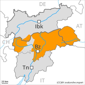
Danger level
 | 2200m
|
Avalanche Problem
 | | Wind-drifted snow |
| | | |
| | Gliding snow |
| | | |
| | Persistent weak layer |
| | | |
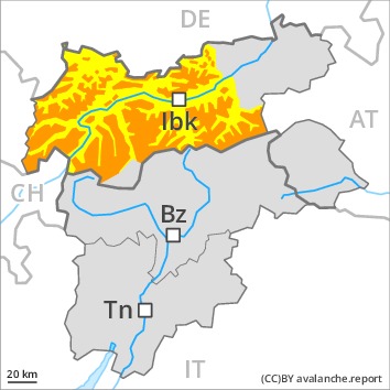
A critical avalanche situation will persist in some cases.
High altitudes and the high Alpine regions: The fresh snow and in particular the sometimes deep wind slabs can be released easily, or, in isolated cases naturally in all aspects. The number and size of avalanche prone locations will increase with altitude. On steep sunny slopes individual loose snow avalanches are possible. Avalanches can also penetrate deep layers and reach dangerously large size.
Low and intermediate altitudes: As the snowfall level drops there will be a gradual decrease in the danger of moist and wet avalanches during the night. A substantial danger of gliding avalanches exists. Areas with glide cracks are to be avoided as far as possible.
In the regions exposed to heavier precipitation the avalanche prone locations are more prevalent and larger. Extensive experience in the assessment of avalanche danger is required.
Snowpack
dp.6: cold, loose snow and wind
dp.2: gliding snow
In some regions up to 15 cm of snow, and even more in some localities, will fall above approximately 1500 m. 10 to 30 cm of snow has fallen thus far above approximately 1800 m. As a consequence of new snow and a sometimes strong southerly wind, avalanche prone wind slabs formed on Sunday in particular in gullies and bowls and behind abrupt changes in the terrain. The snowpack is moist, in particular at low and intermediate altitudes.
Avalanche prone weak layers exist in the centre of the snowpack in all aspects, in particular above approximately 1900 m.
Tendency
Fresh wind slabs require caution. In addition a latent danger of gliding avalanches exists.
Danger level
Avalanche Problem
| | New snow |
| | | |
 | | Wet snow |
| | | |
| | Wind-drifted snow |
| | |  |
As a consequence of new snow and wind a considerable avalanche danger will persist. They can in some places be released by people.
20 to 40 cm of snow fell on Sunday above approximately 1800 m. In some localities 5 to 10 cm of snow, and even more in some localities, will fall above approximately 1200 m. The new snow and wind slabs of the last few days remain for the foreseeable future prone to triggering in all aspects in all altitude zones, especially on very steep slopes, as well as at transitions from a shallow to a deep snowpack. Dry and wet avalanches can be released, even by small loads in isolated cases. As the day progresses individual medium-sized natural avalanches are possible. They can also penetrate deep layers and reach quite a large size. Areas with glide cracks are to be avoided as far as possible.
Snowpack
dp.6: cold, loose snow and wind
dp.3: rain
As a consequence of new snow and a strong southwesterly wind, wind slabs formed, in particular adjacent to ridgelines and in gullies and bowls above the tree line. Over a wide area new snow and wind slabs are lying on the smooth surface of an old snowpack, especially above approximately 1900 m. The old snowpack is moist, in particular at low and intermediate altitudes, as well as in the south also at elevated altitudes. Faceted weak layers exist in the centre of the snowpack.
Tendency
Slight decrease in avalanche danger as the temperature drops.
Danger level
 | 2000m
|
Avalanche Problem
| | Persistent weak layer |
| | | |
| | Gliding snow |
| | | |
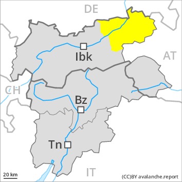
In some places avalanches can be released in the weakly bonded old snow and reach large size.
As a consequence of new snow and a strong to storm force southerly wind, sometimes avalanche prone wind slabs formed. The avalanche prone locations are to be found in particular on near-ridge shady slopes at high altitudes and in high Alpine regions.
Dry avalanches can additionally be released in the weakly bonded old snow by a single winter sport participant. This applies above approximately 2000 m, especially in areas where the snow cover is rather shallow, as well as at transitions from a shallow to a deep snowpack. Between approximately 2000 and 2400 m the avalanche prone locations are more prevalent and the danger is slightly greater. Avalanches can penetrate deep layers and reach dangerously large size. Remotely triggered avalanches are possible in isolated cases. Experience and restraint are required.
An appreciable danger of gliding avalanches exists. This applies in particular in the west and in the northwest. Areas with glide cracks are to be avoided.
Snowpack
dp.6: cold, loose snow and wind
dp.7: snow-poor zones in snow-rich surrounding
Up to 1800 m rain fell yesterday. Above approximately 1000 m snow fell during the night over a wide area. Light northwesterly wind.
The fresh wind slabs are lying on soft layers in particular on shady slopes at high altitudes and in high Alpine regions.
Avalanche prone weak layers exist in the centre of the snowpack, especially between approximately 2000 and 2400 m in all aspects. Released avalanches and stability tests confirm the existence of a weak snowack.
Tendency
The avalanche danger will persist.
Danger level
 | 2000m
|
Avalanche Problem
| | Persistent weak layer |
| | | |
| | Wet snow |
| | | |
Fresh wind slabs require caution.
As a consequence of new snow and a strong to storm force southerly wind, sometimes avalanche prone wind slabs formed. The avalanche prone locations are to be found in particular on near-ridge shady slopes at high altitudes and in high Alpine regions.
Weak layers in the old snowpack can still be released in some places by individual winter sport participants in particular above approximately 2000 m, especially at transitions from a shallow to a deep snowpack.
Snowpack
dp.6: cold, loose snow and wind
dp.7: snow-poor zones in snow-rich surrounding
Up to 1800 m rain fell yesterday over a wide area. Above approximately 1000 m snow fell during the night. Light northwesterly wind. The fresh wind slabs are lying on soft layers in particular on shady slopes at high altitudes and in high Alpine regions.
Avalanche prone weak layers exist in the centre of the snowpack. This applies in particular above approximately 2000 m.
At low altitude a little snow is lying.
Tendency
The avalanche danger will persist.