AM
Danger level
 | 2400m
|
Avalanche Problem
PM
Danger level
 | 2400m
|
Avalanche Problem
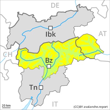
 | | Wet snow |
|  | |  |
 | | Wind-drifted snow |
|  | |  |
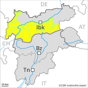
Increase in danger of wet avalanches in the course of the day. Fresh wind slabs require caution.
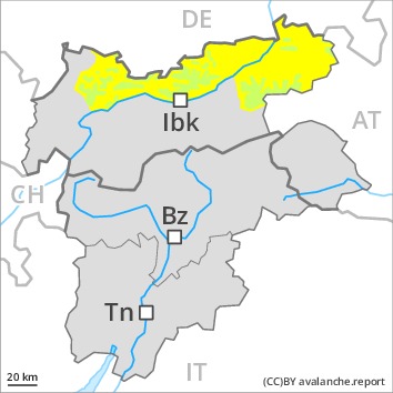
A clear night will be followed in the early morning by quite favourable conditions. As the day progresses as a consequence of warming during the day and solar radiation there will be an increase in the danger of wet and gliding avalanches. This applies especially on very steep sunny slopes below approximately 2400 m, as well as in steep rocky terrain. In isolated cases avalanches are large. Backcountry tours should be concluded timely.
As a consequence of the moderate to strong southwesterly wind, fresh snow drift accumulations will form on Sunday. They can only be released by large loads in most cases. The avalanche prone locations are to be found in particular on very steep shady slopes above approximately 2400 m and adjacent to ridgelines. In the regions exposed to the foehn wind the avalanche prone locations are more prevalent. Avalanches can additionally in very isolated cases be released in deeper layers by large loads, especially in areas where the snow cover is rather shallow. Such avalanche prone locations are very rare.
Snowpack
dp.10: springtime scenario
dp.6: cold, loose snow and wind
Outgoing longwave radiation during the night will be good over a wide area. The surface of the snowpack will freeze to form a strong crust and will soften during the day. The high temperatures will give rise to gradual and thorough wetting of the snowpack, in particular on steep sunny slopes below approximately 2400 m.
The fresh and older wind slabs are lying on soft layers in particular on steep shady slopes above approximately 2400 m. As a consequence of mild temperatures and solar radiation the snow drift accumulations stabilised. Isolated avalanche prone weak layers exist in the centre of the snowpack on steep west, north and east facing slopes.
Tendency
Increase in danger of wet avalanches in the course of the day.
AM
Danger level
| 2400m
|
Avalanche Problem
PM
Danger level
 | 2400m
|
Avalanche Problem
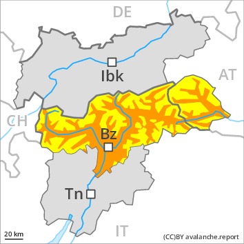
| | Wet snow |
| | | |
| | Wind-drifted snow |
| | | |
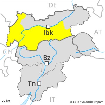
Increase in danger of wet avalanches in the course of the day. Fresh wind slabs require caution.
A clear night will be followed in the early morning by quite favourable conditions, but the danger of wet avalanches will increase later. In the afternoon, many wet and gliding avalanches are to be expected, especially on very steep sunny slopes below approximately 2400 m, as well as in steep rocky terrain. These can in many cases reach medium size.
As a consequence of the moderate to strong southerly foehn wind, fresh snow drift accumulations will form. These can be released in isolated cases especially on very steep shady slopes above approximately 2400 m. Caution is to be exercised in particular adjacent to ridgelines. The prevalence of avalanche prone locations and likelihood of triggering will increase in the regions exposed to the foehn.
Avalanches can additionally in very isolated cases be released in the weakly bonded old snow, in particular by large additional loads, especially on steep west, north and east facing slopes in areas where the snow cover is rather shallow. These avalanche prone locations are very rare.
Snowpack
dp.6: cold, loose snow and wind
dp.7: snow-poor zones in snow-rich surrounding
Outgoing longwave radiation during the night was good over a wide area. The surface of the snowpack will freeze to form a strong crust and will soften during the day. The high temperatures will give rise to gradual and thorough wetting of the snowpack, in particular on steep sunny slopes below approximately 2400 m.
The wind slabs of the last few days are lying on soft layers in particular on steep shady slopes above approximately 2400 m. As a consequence of mild temperatures and solar radiation the snow drift accumulations stabilised. Isolated avalanche prone weak layers exist in the centre of the snowpack.
Tendency
Increase in danger of wet avalanches as a consequence of warming during the day.
AM
Danger level
 | 2200m
|
Avalanche Problem
PM
Danger level
 | 2200m
|
Avalanche Problem
| | Wet snow |
| | | |
| | Wind-drifted snow |
| | | |
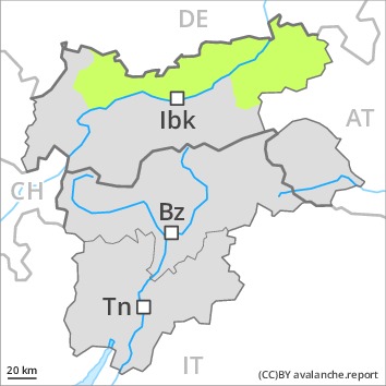
Increase in danger of wet avalanches as a consequence of warming during the day. Wind slabs require caution.
A clear night will be followed in the early morning by favourable conditions generally. As a consequence of warming during the day moist loose snow avalanches are to be expected from midday, in particular medium-sized ones. This applies in particular on very steep sunny slopes, and in steep rocky terrain below approximately 2200 m.
The fresh wind slabs are in isolated cases prone to triggering on steep shady slopes above approximately 2200 m. The avalanche prone locations are to be found in particular adjacent to ridgelines and in gullies and bowls. The avalanches are only small. Wilder Kaiser Mountains- Waidring Alps and Kitzbühel Alps: The fresh wind slabs can be released in isolated cases in particular on steep shady slopes above approximately 1800 m.
Snowpack
dp.6: cold, loose snow and wind
The surface of the snowpack has frozen to form a strong crust and will soften during the day. Towards its surface, the snowpack is moist, in particular on very steep sunny slopes. The high temperatures will give rise to increasing softening of the snowpack on steep sunny slopes below approximately 2200 m.
The mostly small wind slabs are lying on soft layers on shady slopes above approximately 1800 m. As a consequence of rising temperatures the snow drift accumulations will stabilise during the next few days. Individual weak layers exist in the centre of the snowpack. At low altitude a little snow is lying.
Tendency
Increase in danger of wet avalanches as a consequence of warming during the day.