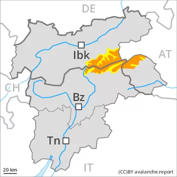
Weakly bonded old snow represents the main danger. Wind slabs and gliding snow require caution.
Weak layers in the old snowpack necessitate caution and restraint. Avalanches can be released, even by a single winter sport participant and reach dangerously large size. Caution is to be exercised in particular on steep shady slopes in areas close to the tree line, as well as above the tree line, also on steep sunny slopes at high altitudes and in high Alpine regions. Remotely triggered avalanches are possible. In addition the wind slabs of the last few days in particular adjacent to ridgelines are easily triggered. These avalanche prone locations are barely recognisable, even to the trained eye. They are currently prevalent immediately adjacent to the pistes as well. A certain danger of gliding avalanches and snow slides exists. This applies on steep grassy slopes below approximately 2200 m. Defensive route selection is recommended.
Snowpack
dp.5: snowfall after a long period of cold dp.2: gliding snow
Over a wide area 20 to 30 cm of snow, and even more in some localities, has fallen since Sunday. The strong wind has transported the new snow significantly. As a consequence of the northwesterly wind the wind slabs will increase in size additionally on Tuesday. The new snow and wind slabs are lying on top of a weakly bonded old snowpack above the tree line. The sometimes new snow-covered wind slabs remain for the foreseeable future prone to triggering. Faceted weak layers exist in the centre of the snowpack, in particular on shady slopes in areas close to the tree line, as well as above the tree line, also on steep sunny slopes at high altitudes and in high Alpine regions. Whumpfing sounds and the formation of shooting cracks when stepping on the snowpack indicate the unfavourable bonding of the snowpack.
Tendency
Down to low altitudes snow will fall on Wednesday over a wide area. The avalanche danger will increase during the day. The snowpack remains prone to triggering, in particular at elevated altitudes.
Danger level
treeline
Avalanche Problem
Persistent weak layer
Treeline
Gliding snow
2200m
Wind-drifted snow
Treeline
Weakly bonded old snow represents the main danger. Wind slabs and gliding snow require caution.
Weak layers in the old snowpack necessitate caution and restraint. Avalanches can be released, even by a single winter sport participant and reach dangerously large size. Caution is to be exercised in particular on steep shady slopes in areas close to the tree line, as well as above the tree line, also on steep sunny slopes at high altitudes and in high Alpine regions. Remotely triggered avalanches are possible. These avalanche prone locations are barely recognisable, even to the trained eye. They are currently prevalent immediately adjacent to the pistes as well. A certain danger of gliding avalanches and snow slides exists. This applies on steep grassy slopes below approximately 2200 m. In addition the wind slabs of the last few days in particular adjacent to ridgelines are easily triggered. The prevalence of these avalanche prone locations will increase with altitude. Defensive route selection is recommended.
Snowpack
dp.5: snowfall after a long period of cold dp.2: gliding snow
Over a wide area 20 to 40 cm of snow, and even more in some localities, has fallen since Saturday. The sometimes strong wind has transported a lot of snow. The new snow and wind slabs are lying on top of a weakly bonded old snowpack above the tree line. Faceted weak layers exist in the centre of the snowpack, in particular on shady slopes in areas close to the tree line, as well as above the tree line, also on steep sunny slopes at high altitudes and in high Alpine regions. Whumpfing sounds and the formation of shooting cracks when stepping on the snowpack indicate the unfavourable bonding of the snowpack. The fresh wind slabs are lying on soft layers at high altitudes and in high Alpine regions. These will become increasingly prone to triggering at elevated altitudes. As a consequence of low temperatures a crust formed on the surface on Sunday, in particular at low and intermediate altitudes.
Tendency
Down to low altitudes snow will fall on Wednesday over a wide area. The avalanche danger will increase during the day. The snowpack remains prone to triggering, in particular at elevated altitudes.
Danger level
treeline
Avalanche Problem
Persistent weak layer
Treeline
Wind-drifted snow
Treeline
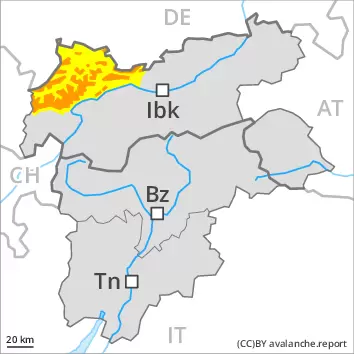
Weakly bonded old snow represents the main danger. Fresh wind slabs require caution.
Weak layers in the old snowpack necessitate caution and restraint. Avalanches can be released, even by a single winter sport participant and reach large size in isolated cases. Caution is to be exercised in particular on steep shady slopes in areas close to the tree line, as well as above the tree line, also on steep sunny slopes at high altitudes and in high Alpine regions. Remotely triggered avalanches are possible in isolated cases. In addition the wind slabs of the last few days in particular adjacent to ridgelines are easily triggered. In the regions exposed to heavier precipitation the avalanche prone locations are more prevalent and larger. They are currently prevalent immediately adjacent to the pistes as well. These avalanche prone locations are barely recognisable, even to the trained eye. Extensive experience in the assessment of avalanche danger is required.
Snowpack
dp.5: snowfall after a long period of cold dp.6: cold, loose snow and wind
Over a wide area 10 to 30 cm of snow, and even more in some localities, fell in the last few days. The strong wind has transported the new snow significantly. As a consequence of the northwesterly wind the wind slabs will increase in size additionally on Tuesday. The new snow and wind slabs are lying on top of a weakly bonded old snowpack above the tree line. The sometimes new snow-covered wind slabs remain for the foreseeable future prone to triggering. Faceted weak layers exist in the centre of the snowpack, in particular on shady slopes in areas close to the tree line, as well as above the tree line, also on steep sunny slopes at elevated altitudes. Whumpfing sounds and the formation of shooting cracks when stepping on the snowpack indicate the unfavourable bonding of the snowpack.
Tendency
Down to low altitudes snow will fall on Wednesday over a wide area. The avalanche danger will increase during the day. The snowpack remains prone to triggering, in particular at elevated altitudes.
Danger level
treeline
Avalanche Problem
Wind-drifted snow
Treeline
Fresh wind slabs represent the main danger.
The fresh wind slabs are prone to triggering in all aspects above the tree line. These can be released even by a single winter sport participant. The avalanche prone locations are to be found in particular adjacent to ridgelines and in gullies and bowls. At elevated altitudes these avalanche prone locations will become more prevalent. In some cases the avalanches are medium-sized. Dry avalanches can additionally in isolated cases be released in deeper layers. This applies in the south, especially on very steep shady slopes in areas close to the tree line, as well as above the tree line. Experience in the assessment of avalanche danger is required.
Snowpack
dp.6: cold, loose snow and wind
10 to 20 cm of snow, and even more in some localities, has fallen since Sunday. The sometimes strong wind has transported a lot of snow. The fresh wind slabs are lying on soft layers at high altitudes and in high Alpine regions. These will become increasingly prone to triggering at elevated altitudes.
Tendency
Down to low altitudes snow will fall on Wednesday over a wide area. Fresh wind slabs represent the main danger, in particular at elevated altitudes.